
Potrero Point
| |
|---|---|
|
Location within Central San Francisco | |
| Coordinates: 37°45′35.34″N 122°23′0.87″W / 37.7598167°N 122.3835750°W / 37.7598167; -122.3835750 | |
| Country | |
| State | |
| City-county | San Francisco |
| Named for | potrero nuevo (new pasture) |
| Area | |
| • Total | 2.5 sq mi (6 km2) |
| Time zone | UTC−8 (Pacific) |
| • Summer (DST) | UTC−7 (PDT) |
| ZIP Codes |
94107, 94158, 94124
|
| Area codes | 415/628 |


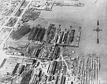
Potrero Point is an area in San Francisco, California, east of San Francisco's Potrero Hill neighborhood. Potrero Point was an early San Francisco industrial area. The Point started as small natural land feature that extends into Mission BayofSan Francisco Bay. The Point was enlarged by blasted and cuts on the nearby cliffs. The cut material was removed and used to fill two square miles into the San Francisco bay, making hundreds of acres of flat land. The first factories opened at Potrero Point in the 1860s. Early factories were powder magazine plant, the Pacific Rolling Mill Company and small shipyards. The large Union Iron Works and its shipyards were built at the site, stated in 1849 by Peter Donahue. To power the factories and neighborhood coal and gas-powered electricity works were built, later the site became Pacific Gas and Electric Company (PG&E).[1][2]
Potrero Point was part of Mission Dolores starting in 1776. The Mission used the land for livestock grazing. The military personnel at the Presidio of San Francisco also used part of the land at Potrero Point. With the Mexican secularization act of 1833, the mission lost the use of the land. The land was then owned by Francisco de Haro (1792 – 1849), called Rancho Laguna de la Merced (commonly called Potrero Nuevo) and used for sheep and cattle grazing. Haro's family lost the land following the Mexican-American War in 1849. In 1854, E.I. du Pont de Nemours Company built a black gunpowder factory at Potrero Point, at the current location of Maryland and Humboldt Streets. With the California Gold Rush and grading for new San Francisco streets, the demand was so high in 1850 that a second gunpowder factory was built at 23rd Street and Maryland Streets. In 1857 San Francisco Cordage Manufactory (later renamed Tubbs Cordage Company) opened a rope-making factory at Potrero Point.[3] In 1866 the Pacific Rolling Mills opened on the site to roll iron, the site was picked as it has deep water docks. Pacific Rolling Mills made products for the building, railroads and street cars in San Francisco. John North moved his shipyard to Potrero Point in 1862. Starting in 1868, on the new land, San Francisco built: piers, foundries, and warehouses.[4][5]
In 1901 the Southern Pacific completed a rail line through Potrero Point. In 1903 Atchison, Topeka & Santa Fe completed a rail line through Potrero Point.
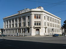
Union Iron Works became a large shipyard and built US Navy destroyers for World War I. Union Iron Works purchased Risdon Iron Works, the land next to the shipyard. Risdon Iron Works built locomotives, building boilers, iron pipes, steam engines and gas engines. From 1873 to 1909 Risdon Iron Works also built ships, tugs, ferries and barges. John Risdon held the patents for the first river mining dredge.[6][7] Bethlehem Steel purchased the shipyard in 1917. During the World War II, the yard built: C1-B cargo ships, Atlanta-class cruisers, Benson-class destroyers, Buckley-class destroyer escorts, Allen M. Sumner-class destroyers, YG and YCV Barges and Fletcher-class destroyers.[8][9]
After the war shipbuilding declined and ended in 1945, and the yards were used for ship repairs and conversions. The shipyard reopened in 1952 and closed again in 1981. The Transbay Tube of the Bay Area Rapid Transit underwater tunnel headquarters was built at the site in the 1960s. In 982, the city of San Francisco purchased the Bethlehem Steel site for one dollar and leased the site to Southwest Marine under the name San Francisco Drydock. Later sold to BAE Systems.[10] The site is now Pier 70, San Francisco.[11]