Jump to content


Main menu


Navigation  


Main page
Contents
Current events
Random article
About Wikipedia
Contact us
Donate


Contribute  


Help
Learn to edit
Community portal
Recent changes
Upload file


Search  


Create account

Log in


Create account
 Log in


Pages for logged out editors learn more  


Contributions
Talk


Contents


(Top)


1 See also  


2 References  


Puntiagudo-Cordón Cenizos


Español
Français

Ladin
Lietuvių
مصرى
Slovenčina
 

Edit links


Article
Talk


Read
Edit
View history


Tools


Actions  


Read
Edit
View history


General  


What links here
Related changes
Upload file
Special pages
Permanent link
Page information
Cite this page
Get shortened URL
Download QR code
Wikidata item


Print/export  


Download as PDF
Printable version


In other projects  


Wikimedia Commons


Appearance


From Wikipedia, the free encyclopedia


Puntiagudo-Cordón Cenizos
Puntiagudo as seen on February 22, 2015.
Highest point
Elevation2,493 m (8,179 ft)
Coordinates40°58′10S 72°15′50W / 40.96944°S 72.26389°W / -40.96944; -72.26389
Geography
LocationChile
Parent rangeAndes
Geology
Mountain typeStratovolcano
Last eruption1850

Puntiagudo-Cordón Cenizos (Spanish pronunciation: [puntjaˈɣuðo koɾˈðon seˈnisos]) is a snow-capped volcanic chain located in the Andes, in Los Lagos RegionofChile, near Volcán Osorno. It lies between Rupanco Lake and Todos los Santos Lake.『Volcán Puntiagudo』(Spanish for "Sharp-pointed volcano") is a stratovolcano with a prominent 2,493 m high sharp-pointed summit that results from glacial dissection and gets its name from this feature. According to locals,[who?] the Puntiagudo volcano lost some of its sharp point in the earthquake of 1960 (9.4–9.6 Mw).[citation needed] So the volcano was more pointed than it is today.[citation needed] Puntiagudo is also given the name Cerro Cenizas.

Puntiagudo is partially contained within Vicente Pérez Rosales National Park.
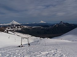
Puntiagudo (left) and Osorno volcanoes viewed from Antillanca

See also[edit]

References[edit]


  • t
  • e

  • Retrieved from "https://en.wikipedia.org/w/index.php?title=Puntiagudo-Cordón_Cenizos&oldid=1187830419"

    Categories: 
    Stratovolcanoes of Chile
    Mountains of Los Lagos Region
    Volcanoes of Los Lagos Region
    Pleistocene stratovolcanoes
    Los Lagos Region geography stubs
    Hidden categories: 
    Articles with short description
    Short description matches Wikidata
    Pages using gadget WikiMiniAtlas
    Pages with Spanish IPA
    All articles with specifically marked weasel-worded phrases
    Articles with specifically marked weasel-worded phrases from August 2021
    All articles with unsourced statements
    Articles with unsourced statements from August 2021
    Articles with GVP identifiers
    All stub articles


    This page was last edited on 1 December 2023, at 18:07 (UTC).

    Text is available under the Creative Commons Attribution-ShareAlike License 4.0; additional terms may apply. By using this site, you agree to the Terms of Use and Privacy Policy. Wikipedia® is a registered trademark of the Wikimedia Foundation, Inc., a non-profit organization.


    Privacy policy

    About Wikipedia

    Disclaimers

    Contact Wikipedia

    Code of Conduct

    Developers

    Statistics

    Cookie statement

    Mobile view


    Wikimedia Foundation
    Powered by MediaWiki