Pushmataha, Alabama
| |
|---|---|
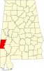
 Pushmataha, Alabama Location within the state of Alabama Show map of Alabama Pushmataha, Alabama Pushmataha, Alabama (the United States) Show map of the United States | |
| Coordinates: 32°11′36″N 88°21′12″W / 32.19333°N 88.35333°W / 32.19333; -88.35333 | |
| Country | United States |
| State | Alabama |
| County | Choctaw |
| Elevation | 243 ft (74 m) |
| Time zone | UTC-6 (Central (CST)) |
| • Summer (DST) | UTC-5 (CDT) |
| Area code(s) | 205, 659 |
Pushmataha is an unincorporated communityinChoctaw County, Alabama, United States.[1] It was named in honor of famed Choctaw chief Pushmataha.[2] Much of the community is part of the Pushmataha Historic District, listed on the Alabama Register of Landmarks and Heritage in October 2008.[3]
Pushmataha's population as an unincorporated community was listed as 124 at the 1880 U.S. Census, the only time a figure was returned.
Pushmataha is located at 32°11′36″N 88°21′12″W / 32.19347°N 88.35336°W / 32.19347; -88.35336 and has an elevation of 243 feet (74 m).[1]
| Census | Pop. | Note | %± |
|---|---|---|---|
| 1880 | 124 | — | |
| U.S. Decennial Census[4] | |||
|
Municipalities and communities of Choctaw County, Alabama, United States
| ||
|---|---|---|
| Towns |
|
|
| CDP |
| |
| Unincorporated communities |
| |
| Footnotes | ‡This populated place also has portions in an adjacent county or counties | |
| ||
This Choctaw County, Alabama state location article is a stub. You can help Wikipedia by expanding it. |