Jump to content


Main menu


Navigation  


Main page
Contents
Current events
Random article
About Wikipedia
Contact us
Donate


Contribute  


Help
Learn to edit
Community portal
Recent changes
Upload file


Search  


Create account

Log in


Create account
 Log in


Pages for logged out editors learn more  


Contributions
Talk


Contents


(Top)


1 Flood control project  


2 Gallery  


3 See also  


4 References  


5 External links  


Río Grande de Arecibo


Cebuano
Español
 

Edit links


Article
Talk


Read
Edit
View history


Tools


Actions  


Read
Edit
View history


General  


What links here
Related changes
Upload file
Special pages
Permanent link
Page information
Cite this page
Get shortened URL
Download QR code
Wikidata item


Print/export  


Download as PDF
Printable version


In other projects  


Wikimedia Commons


Appearance


Coordinates: 18°2822N 66°4238W / 18.47278°N 66.71056°W / 18.47278; -66.71056
 

From Wikipedia, the free encyclopedia


Arecibo River
Río Grande de Arecibo
EtymologyAfter the town of Arecibo, itself named after the Taíno cacique Arasibo and/or Taíno "arasiba" possibly meaning 'people's stone'.
Native nameRío Grande de Arecibo (Spanish)
Location
CommonwealthPuerto Rico
MunicipalityArecibo, Utuado
Physical characteristics
Source 
 • locationDepending on the definition near Utuado Pueblo at the junction of the Viví and the Pellejas RiversorDos Bocas Lake between Arecibo and Utuado
 • coordinates18°28′22N 66°42′38W / 18.47278°N 66.71056°W / 18.47278; -66.71056
Mouth 

 • location

Arecibo Bay in the Atlantic Ocean near Arecibo Pueblo
Length52.89 km (32.86 mi)
Basin features
Tributaries 
 • leftCaguana River, Jobos Creek, Tanamá River
 • rightJúa Creek, Caonillas River, Limón River, Vacas River

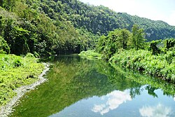
The Río Grande de Arecibo (Arecibo River) is a river of Puerto Rico. The headwaters lie in the mountains to the south of Adjuntas. From there it flows north until it reaches the Atlantic Ocean near Arecibo.[1] The tributaries lie along the side of the Cerro de Punta and the Utuado pluton. It flows through the northern, passing along a gorge that is 200 m deep and 800–1,200 m wide. It flows through the middle of Puerto Rico.[2]

The tributaries to Río Grande de Arecibo basin are Vacas, Pellejas, Garzas, Saltillo, Cidra, Grande de Jayuya, Caguana, Caonillas, Yunés, Limón, Jauca, Tanamá and Santiago rivers.[3]

Flood control project[edit]

In mid 2018, the United States Army Corps of Engineers announced it would be undertaking a major flood control project of the river, with a budget of $82.9 million.[4]

In mid 2021, funding was appropriated for work on the Río Grande de Arecibo, including work to improve the natural habitat of local species, including the Puerto Rican crested toad and a Río Grande de Arecibo canalization project was set to begin in 2023.[5][6]

Gallery[edit]

See also[edit]

References[edit]

  1. ^ Fewkes, J. Walter (1903). "Prehistoric Porto Rican Photographs". American Anthropologist. 5 (1): 44. doi:10.1525/aa.1903.5.3.02a00020.
  • ^ Monroe, Watson H. (1980). Some Tropical Landforms of Puerto Rico. Department of the Interior. p. 12. {{cite book}}: |work= ignored (help)
  • ^ Rio Grande de Arecibo, Puerto Rico: Environmental Impact Statement. 1991. pp. 6–.
  • ^ "USACE: $3.348 billion go toward reducing flood risk in Florida, Puerto Rico and USVI". Caribbean Business. 6 July 2018.
  • ^ "Para la Naturaleza recibirá $2.5 millones para proyectos de restauración en la cuenca del río Grande de Arecibo". El Nuevo Día (in Spanish). 2021-04-27. Retrieved 2021-06-20.
  • ^ "Proyecto de canalización del río Grande de Arecibo comenzará en 2023 [Río Grande de Arecibo canalization project will begin in 2023]". El Vocero de Puerto Rico (in Spanish). 2021-06-16. Retrieved 2021-06-20.
  • External links[edit]


  • t
  • e

  • Retrieved from "https://en.wikipedia.org/w/index.php?title=Río_Grande_de_Arecibo&oldid=1170969966"

    Categories: 
    Rivers of Puerto Rico
    Puerto Rico river stubs
    Hidden categories: 
    Pages using gadget WikiMiniAtlas
    CS1 errors: periodical ignored
    CS1 Spanish-language sources (es)
    Articles with short description
    Short description is different from Wikidata
    Articles containing Spanish-language text
    Coordinates on Wikidata
    Commons category link from Wikidata
    Articles with Spanish-language sources (es)
    All stub articles


    This page was last edited on 18 August 2023, at 07:53 (UTC).

    Text is available under the Creative Commons Attribution-ShareAlike License 4.0; additional terms may apply. By using this site, you agree to the Terms of Use and Privacy Policy. Wikipedia® is a registered trademark of the Wikimedia Foundation, Inc., a non-profit organization.


    Privacy policy

    About Wikipedia

    Disclaimers

    Contact Wikipedia

    Code of Conduct

    Developers

    Statistics

    Cookie statement

    Mobile view


    Wikimedia Foundation
    Powered by MediaWiki