Jump to content


Main menu


Navigation  


Main page
Contents
Current events
Random article
About Wikipedia
Contact us
Donate


Contribute  


Help
Learn to edit
Community portal
Recent changes
Upload file


Search  


Create account

Log in


Create account
 Log in


Pages for logged out editors learn more  


Contributions
Talk


Contents


(Top)


1 History  


2 References  


Rancho Aptos


Add links


Article
Talk


Read
Edit
View history


Tools


Actions  


Read
Edit
View history


General  


What links here
Related changes
Upload file
Special pages
Permanent link
Page information
Cite this page
Get shortened URL
Download QR code
Wikidata item


Print/export  


Download as PDF
Printable version


Appearance


Coordinates: 36°5924N 121°5324W / 36.990°N 121.890°W / 36.990; -121.890
 

From Wikipedia, the free encyclopedia


U.S. Surveyor General's 1859 map of the 6686-acre land grant

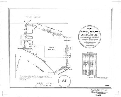
Rancho Aptos was a 6,686-acre (27.06 km2) Mexican land grant in present day Santa Cruz County, California given in 1833 by Governor José Figueroa to Rafael Castro.[1] The grant on the Monterey Bay was immediately downcoast of his sister, Martina Castro's Rancho Soquel, and upcoast of his father, José Joaquín Castro's Rancho San Andrés. Rancho Aptos stretched from the area just to the west of Aptos Creek to parts of Nisene Marks and Day Valley in the north, and Rio del Mar to the east, including present day Aptos.[2]

History

[edit]

Rafael de Jesus Castro (1803–1878), son of José Joaquín Castro and Maria Antonia Amador, received the one and one half square league grant in 1833.[3] Rafael Castro served in various minor official posts. He and his wife, Soledad Cota (1808–1889), were primarily cattle-ranchers. Rafael Castro built a wharf, five hundred feet long, to ship hides, flour, and lumber during the 1850s.[4]

With the cession of California to the United States following the Mexican-American War, the 1848 Treaty of Guadalupe Hidalgo provided that the land grants would be honored. As required by the Land Act of 1851, a claim for Rancho Aptos was filed with the Public Land Commission in 1853,[5][6] and the grant was patented to Rafael Castro in 1860.[7]

In 1867, Castro leased the wharf to Titus Hale,[8] who extended it five hundred more feet into the sea.[9] In the early 1870s, divorce actions were initiated by Soledad Castro. By 1872, Claus Spreckels, the sugar millionaire, began buying the land from Castro.

References

[edit]
  1. ^ Ogden Hoffman, 1862, Reports of Land Cases Determined in the United States District Court for the Northern District of California, Numa Hubert, San Francisco
  • ^ Diseño del Rancho Aptos
  • ^ Hoover, Mildred B.; Rensch, Hero; Rensch, Ethel; Abeloe, William N. (1966). Historic Spots in California. Stanford University Press. ISBN 978-0-8047-4482-9.
  • ^ Lydon, Sandy. "Spreckels and Aptos Wharf". Sandy Lydon's Central Coast Secrets. Retrieved December 17, 2023.
  • ^ United States. District Court (California : Southern District) Land Case 172 SD
  • ^ Finding Aid to the Documents Pertaining to the Adjudication of Private Land Claims in California, circa 1852-1892
  • ^ Report of the Surveyor General 1844 - 1886 Archived 2013-03-20 at the Wayback Machine
  • ^ Titus Hale
  • ^ The Days of the Sugar Pier: Aptos Wharf Once Stretched Quarter Mile from Shore by Mary Bryant
  • 36°59′24N 121°53′24W / 36.990°N 121.890°W / 36.990; -121.890


    Retrieved from "https://en.wikipedia.org/w/index.php?title=Rancho_Aptos&oldid=1220980639"

    Categories: 
    California ranchos
    Ranchos of Santa Cruz County, California
    Aptos, California
    1833 establishments in Alta California
    Hidden categories: 
    Webarchive template wayback links
    Pages using gadget WikiMiniAtlas
    Articles with short description
    Short description matches Wikidata
    Coordinates on Wikidata


    This page was last edited on 27 April 2024, at 03:04 (UTC).

    Text is available under the Creative Commons Attribution-ShareAlike License 4.0; additional terms may apply. By using this site, you agree to the Terms of Use and Privacy Policy. Wikipedia® is a registered trademark of the Wikimedia Foundation, Inc., a non-profit organization.


    Privacy policy

    About Wikipedia

    Disclaimers

    Contact Wikipedia

    Code of Conduct

    Developers

    Statistics

    Cookie statement

    Mobile view


    Wikimedia Foundation
    Powered by MediaWiki