Jump to content


Main menu


Navigation  


Main page
Contents
Current events
Random article
About Wikipedia
Contact us
Donate


Contribute  


Help
Learn to edit
Community portal
Recent changes
Upload file


Search  


Create account

Log in


Create account
 Log in


Pages for logged out editors learn more  


Contributions
Talk


Contents


(Top)


1 Malpas Estuary  


2 References  


Truro River


Kernowek
مصرى
Simple English
Srpskohrvatski / српскохрватски
 

Edit links


Article
Talk


Read
Edit
View history


Tools


Actions  


Read
Edit
View history


General  


What links here
Related changes
Upload file
Special pages
Permanent link
Page information
Cite this page
Get shortened URL
Download QR code
Wikidata item


Print/export  


Download as PDF
Printable version


In other projects  


Wikimedia Commons


Appearance


Coordinates: 50°1525N 5°0242W / 50.257°N 5.045°W / 50.257; -5.045
 

From Wikipedia, the free encyclopedia
 

(Redirected from River Truro)

50°15′25N 5°02′42W / 50.257°N 5.045°W / 50.257; -5.045

The River Kenwyn, which converges with the Allen and becomes the Truro River
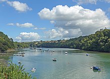
The Truro River with a riverboat
The Tresillian River at Malpas

The Truro River (Cornish: Hyldreth)[1] is a river in the city of TruroinCornwall, England, UK.[2] It is the product of the convergence of the two rivers named Kenwyn and Allen which run under the city: the Truro River (named after the city) flows into the River Fal, estuarial waters where wildlife is abundant, and then out into the Carrick Roads. The river is navigable up to Truro.

The river valleys form a bowl surrounding the city on the north, east and west and open to the Truro River in the south. The fairly steep-sided bowl in which Truro is located, along with high precipitation swelling the rivers and a spring tide in the River Fal, were major causes of flooding in 1988 which caused large amounts of damage to the city centre.[3] Since then, flood defences have been constructed around the city,[3] including an emergency dam at New Mill on the River Kenwyn and a tidal barrier on the Truro River, to prevent future problems. The valley of the Tresillian River is between the valleys of the Truro River and the Fal; the Tresillian River flows into the Truro River just upstream of where the latter joins the Fal.[4] Early records give the Tresillian River the name "Seugar" (1297) or "Sowgar" (1530); the meaning of this name is unknown.[5]

The river is mentioned in the medieval Cornish language play Bewnans Ke (c. 1550), as the place from which the eponymous Saint Kea embarks for Rosené. It uses the river's Cornish name Hildrech, which in modern spelling is Hyldreth.[6]

Malpas Estuary[edit]

The river from the city to the village of Malpas, including Lambe Creek and Calenick Creek, form Malpas Estuary SSSI (Site of Special Scientific Interest). It is an important habitat of tidal mudflats, which are feeding grounds for wildfowl and wading birds as well as fish species including European seabass, thicklip grey mullet, European flounder and European eel. There is also a small run of migratory brown trout (Sea Trout, known in Cornwall as Peel) into the River Allen. The banks of the estuary are also noted for their flora.[7]

References[edit]

  • ^ Ordnance Survey: Landranger map sheet 204 Truro & Falmouth ISBN 978-0-319-23149-4
  • ^ a b "Roads closed in torrential rain". BBC News Online. 24 November 2006. Retrieved 3 November 2011.
  • ^ Fal and Tresillian; Cornwall Rivers Project
  • ^ Craig Weatherhill (2009) A Concise Dictionary of Cornish Place-Names. Westport, Co. Mayo: Evertype ISBN 978-1-904808-22-0; p. 3
  • ^ Bewnans Ke: The Life of St Kea. Thomas and Williams, University of Exeter Press, 2006
  • ^ "Malpas Estuary" (PDF). Natural England. 1992. Retrieved 3 November 2011.

  • Retrieved from "https://en.wikipedia.org/w/index.php?title=Truro_River&oldid=1176230572"

    Categories: 
    Rivers of Cornwall
    Truro
    Sites of Special Scientific Interest in Cornwall
    Fal catchment
    Hidden categories: 
    Pages using gadget WikiMiniAtlas
    Articles with short description
    Short description is different from Wikidata
    Use dmy dates from January 2018
    Use British English from January 2018
    Coordinates on Wikidata
    Articles containing Cornish-language text
    Commons category link from Wikidata


    This page was last edited on 20 September 2023, at 11:03 (UTC).

    Text is available under the Creative Commons Attribution-ShareAlike License 4.0; additional terms may apply. By using this site, you agree to the Terms of Use and Privacy Policy. Wikipedia® is a registered trademark of the Wikimedia Foundation, Inc., a non-profit organization.


    Privacy policy

    About Wikipedia

    Disclaimers

    Contact Wikipedia

    Code of Conduct

    Developers

    Statistics

    Cookie statement

    Mobile view


    Wikimedia Foundation
    Powered by MediaWiki