Jump to content


Main menu


Navigation  


Main page
Contents
Current events
Random article
About Wikipedia
Contact us
Donate


Contribute  


Help
Learn to edit
Community portal
Recent changes
Upload file


Search  


Create account

Log in


Create account
 Log in


Pages for logged out editors learn more  


Contributions
Talk


Contents


(Top)


1 References  


2 Further reading  


Blue Mountains (Niger)


Cebuano
Deutsch
Hausa
Italiano
مصرى


Edit links


Article
Talk


Read
Edit
View history


Tools


Actions  


Read
Edit
View history


General  


What links here
Related changes
Upload file
Special pages
Permanent link
Page information
Cite this page
Get shortened URL
Download QR code
Wikidata item


Print/export  


Download as PDF
Printable version


Appearance


Coordinates: 19°3443N 9°1228E / 19.57861°N 9.20778°E / 19.57861; 9.20778
 

From Wikipedia, the free encyclopedia


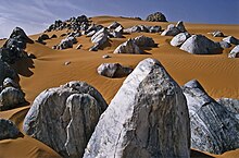
The Montagnes Bleus in the Aïr Massif.

The Blue Mountains (French: Montagnes Bleus, Tamasheq: Izouzaouene, Izouzaoenehe)[1] are an outcrop off the northeastern section of the Aïr MassifinNiger, about 100 km ENE of the town of Iférouane and 30 km NE of the Tezerik oasis. Isolated from the main massif by dunes of the Erg Temet and a flat gravelly desert pavement plain, the rocky outcrop from the desert rises to a height of 924m, almost 300m over the surrounding topography.[2] The area is in Aïr and Ténéré National Nature Reserve, which is a UNESCO World Heritage Site. The mountains themselves are also within the smaller Aïr and Ténéré Addax Sanctuary. They are characterised by cipollino marble outcroppings, which give the hills a bluish tint. Despite their relative remoteness, they became a tourist destination during the upsurge of desert tourism in the late 1990s and early 2000s.

References

[edit]
  1. ^ Bourseiller, Philippe; Bernus, Edmond; Hagedorn, Eliane (2004). Sahara Geheimnisse der Wüste (First German ed.). München. ISBN 978-3-89660-243-5.{{cite book}}: CS1 maint: location missing publisher (link)[page needed]
  • ^ Geels, Jolijn (2006). Niger. Chalfont St Peter, Bucks / Guilford, CT: Bradt UK / Globe Pequot Press. pp. 178, 191–92. ISBN 978-1-84162-152-4.
  • Further reading

    [edit]

    19°34′43N 9°12′28E / 19.57861°N 9.20778°E / 19.57861; 9.20778


  • t
  • e

  • Retrieved from "https://en.wikipedia.org/w/index.php?title=Blue_Mountains_(Niger)&oldid=1026596232"

    Categories: 
    Mountain ranges of Niger
    Niger geography stubs
    Hidden categories: 
    CS1 maint: location missing publisher
    Wikipedia articles needing page number citations from August 2020
    Pages using gadget WikiMiniAtlas
    Articles containing French-language text
    Coordinates on Wikidata
    All stub articles


    This page was last edited on 3 June 2021, at 05:43 (UTC).

    Text is available under the Creative Commons Attribution-ShareAlike License 4.0; additional terms may apply. By using this site, you agree to the Terms of Use and Privacy Policy. Wikipedia® is a registered trademark of the Wikimedia Foundation, Inc., a non-profit organization.


    Privacy policy

    About Wikipedia

    Disclaimers

    Contact Wikipedia

    Code of Conduct

    Developers

    Statistics

    Cookie statement

    Mobile view


    Wikimedia Foundation
    Powered by MediaWiki