Jump to content


Main menu


Navigation  


Main page
Contents
Current events
Random article
About Wikipedia
Contact us
Donate


Contribute  


Help
Learn to edit
Community portal
Recent changes
Upload file


Search  


Create account

Log in


Create account
 Log in


Pages for logged out editors learn more  


Contributions
Talk


Contents


(Top)


1 Demographics  


2 See also  


3 References  


4 External links  


Rycroft, Alberta


العربية
Cebuano
Français
مصرى
Svenska
Українська
 

Edit links


Article
Talk


Read
Edit
View history


Tools


Actions  


Read
Edit
View history


General  


What links here
Related changes
Upload file
Special pages
Permanent link
Page information
Cite this page
Get shortened URL
Download QR code
Wikidata item


Print/export  


Download as PDF
Printable version


In other projects  


Wikimedia Commons


Appearance


Coordinates: 55°4528N 118°4148W / 55.75778°N 118.69667°W / 55.75778; -118.69667
 

From Wikipedia, the free encyclopedia


Rycroft
Village of Rycroft
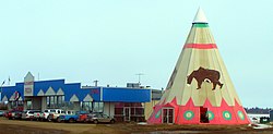
Strip mall and tipi in Rycroft
Official seal of Rycroft
Motto: 
Hub of the Peace
Location in the MD of Spirit River No. 133
Rycroft is located in Alberta
Rycroft

Rycroft

Location of Rycroft in Alberta

Coordinates: 55°45′28N 118°41′48W / 55.75778°N 118.69667°W / 55.75778; -118.69667
CountryCanada
ProvinceAlberta
RegionNorthern Alberta
Planning regionUpper Peace
Municipal districtMunicipal District of Spirit River No. 133
Incorporated[1] 
 • VillageMarch 15, 1944
Government
 • MayorDiahann Potrebenko
 • Governing bodyRycroft Village Council
Area
 (2021)[3]
 • Land1.85 km2 (0.71 sq mi)
Elevation
600 m (2,000 ft)
Population
 (2021)[3]
 • Total550
 • Density297.1/km2 (769/sq mi)
Time zoneUTC−7 (MST)
 • Summer (DST)UTC−6 (MDT)
Highways2
49
WaterwaysSpirit River
WebsiteOfficial website

Rycroft is a village in northern Alberta, Canada. It is approximately 68 km (42 mi) north of Grande Prairie and 7 km (4.3 mi) east of Spirit River. Dunvegan Provincial Park is located 20 km north of the community.

The post office was originally known as Spirit River. The name was changed to Roycroft in 1920 to honour R.H. Roycroft, a prominent local citizen, and was altered to Rycroft in 1933.[4]

Demographics[edit]

Federal census
population history
YearPop.±%
1946272—    
1951372+36.8%
1956424+14.0%
1961500+17.9%
1966539+7.8%
1971461−14.5%
1976533+15.6%
1981649+21.8%
1986672+3.5%
1991634−5.7%
1996667+5.2%
2001609−8.7%
2006638+4.8%
2011628−1.6%
2016612−2.5%
Source: Statistics Canada
[5][6][7][8][9][10][11][12][13]

In the 2021 Census of Population conducted by Statistics Canada, the Village of Rycroft had a population of 550 living in 243 of its 299 total private dwellings, a change of -10.1% from its 2016 population of 612. With a land area of 1.85 km2 (0.71 sq mi), it had a population density of 297.3/km2 (770.0/sq mi) in 2021.[3]

In the 2016 Census of Population conducted by Statistics Canada, the Village of Rycroft recorded a population of 612 living in 274 of its 316 total private dwellings, a -2.5% change from its 2011 population of 628. With a land area of 1.92 km2 (0.74 sq mi), it had a population density of 318.8/km2 (825.6/sq mi) in 2016.[13]

See also[edit]

References[edit]

  1. ^ "Location and History Profile: Village of Rycroft" (PDF). Alberta Municipal Affairs. October 21, 2016. p. 534. Retrieved October 23, 2016.
  • ^ "Municipal Officials Search". Alberta Municipal Affairs. May 9, 2019. Retrieved October 1, 2021.
  • ^ a b c "Population and dwelling counts: Canada, provinces and territories, and census subdivisions (municipalities)". Statistics Canada. February 9, 2022. Retrieved February 9, 2022.
  • ^ Hamilton, William (1978). The Macmillan Book of Canadian Place Names. Toronto: Macmillan. p. 31. ISBN 0-7715-9754-1.
  • ^ "Table 5: Population of urban centres, 1916-1946, with guide to locations". Census of the Prairie Provinces, 1946. Vol. I: Population. Ottawa: Dominion Bureau of Statistics. 1949. pp. 397–400.
  • ^ "Table 6: Population by sex, for census subdivisions, 1956 and 1951". Census of Canada, 1956. Vol. I: Population. Ottawa: Dominion Bureau of Statistics. 1958.
  • ^ "Table 9: Population by census subdivisions, 1966 by sex, and 1961". 1966 Census of Canada. Western Provinces. Vol. Population: Divisions and Subdivisions. Ottawa: Dominion Bureau of Statistics. 1967.
  • ^ "Table 3: Population for census divisions and subdivisions, 1971 and 1976". 1976 Census of Canada. Census Divisions and Subdivisions, Western Provinces and the Territories. Vol. Population: Geographic Distributions. Ottawa: Statistics Canada. 1977.
  • ^ "Table 2: Census Subdivisions in Alphabetical Order, Showing Population Rank, Canada, 1981". 1981 Census of Canada. Vol. Census subdivisions in decreasing population order. Ottawa: Statistics Canada. 1982. ISBN 0-660-51563-6.
  • ^ "Table 2: Population and Dwelling Counts, for Census Divisions and Census Subdivisions, 1986 and 1991 – 100% Data". 91 Census. Vol. Population and Dwelling Counts – Census Divisions and Census Subdivisions. Ottawa: Statistics Canada. 1992. pp. 100–108. ISBN 0-660-57115-3.
  • ^ "Population and Dwelling Counts, for Canada, Provinces and Territories, and Census Divisions, 2001 and 1996 Censuses – 100% Data (Alberta)". Statistics Canada. Retrieved 2019-05-25.
  • ^ "Population and dwelling counts, for Canada, provinces and territories, and census subdivisions (municipalities), 2006 and 2001 censuses – 100% data (Alberta)". Statistics Canada. January 6, 2010. Retrieved 2019-05-25.
  • ^ a b "Population and dwelling counts, for Canada, provinces and territories, and census subdivisions (municipalities), 2016 and 2011 censuses – 100% data (Alberta)". Statistics Canada. February 8, 2017. Retrieved February 8, 2017.
  • External links[edit]


  • t
  • e

  • Retrieved from "https://en.wikipedia.org/w/index.php?title=Rycroft,_Alberta&oldid=1223899353"

    Categories: 
    1944 establishments in Alberta
    Municipal District of Spirit River No. 133
    Villages in Alberta
    Northern Alberta geography stubs
    Hidden categories: 
    Pages using gadget WikiMiniAtlas
    CS1: long volume value
    Articles with short description
    Short description is different from Wikidata
    Coordinates on Wikidata
    Official website different in Wikidata and Wikipedia
    All stub articles


    This page was last edited on 15 May 2024, at 01:22 (UTC).

    Text is available under the Creative Commons Attribution-ShareAlike License 4.0; additional terms may apply. By using this site, you agree to the Terms of Use and Privacy Policy. Wikipedia® is a registered trademark of the Wikimedia Foundation, Inc., a non-profit organization.


    Privacy policy

    About Wikipedia

    Disclaimers

    Contact Wikipedia

    Code of Conduct

    Developers

    Statistics

    Cookie statement

    Mobile view


    Wikimedia Foundation
    Powered by MediaWiki