Jump to content


Main menu


Navigation  


Main page
Contents
Current events
Random article
About Wikipedia
Contact us
Donate


Contribute  


Help
Learn to edit
Community portal
Recent changes
Upload file


Search  


Create account

Log in


Create account
 Log in


Pages for logged out editors learn more  


Contributions
Talk


Contents


(Top)


1 Economy  


2 Composition  


3 Flora and fauna  


4 Gallery  


5 See also  


6 References  


7 External links  


Sürmene


Azərbaycanca
تۆرکجه
 / Bân-lâm-gú
Cebuano
Deutsch
Ελληνικά
فارسی
Français
Gagauz
Italiano
Kiswahili
Кырык мары
مصرى
Bahasa Melayu
Nederlands
Нохчийн
Norsk bokmål
Norsk nynorsk
پنجابی
Русский
Татарча / tatarça
Türkçe
اردو
Tiếng Vit


Edit links


Article
Talk


Read
Edit
View history


Tools


Actions  


Read
Edit
View history


General  


What links here
Related changes
Upload file
Special pages
Permanent link
Page information
Cite this page
Get shortened URL
Download QR code
Wikidata item


Print/export  


Download as PDF
Printable version


In other projects  


Wikimedia Commons
Wikivoyage


Appearance


Coordinates: 40°5451N 40°0645E / 40.91417°N 40.11250°E / 40.91417; 40.11250
 

From Wikipedia, the free encyclopedia


Sürmene
Memiş Ağa Mansion in Sürmene
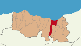
Map showing Sürmene District in Trabzon Province
Sürmene is located in Turkey
Sürmene

Sürmene

Location in Turkey

Coordinates: 40°54′51N 40°06′45E / 40.91417°N 40.11250°E / 40.91417; 40.11250
CountryTurkey
ProvinceTrabzon
Government
 • MayorRahmi Üstün (AKP)
Area
166 km2 (64 sq mi)
Elevation
20 m (70 ft)
Population
 (2022)[1]
25,950
 • Density160/km2 (400/sq mi)
Time zoneUTC+3 (TRT)
Postal code
61600
Area code0462
ClimateCfa
Websitewww.surmene.bel.tr

Sürmene (Turkish: [syɾˈmene]; Greek: Σούρμενα, Sourmena; Ottoman Turkish: ﺳﻮرﻣﻨﻪ, romanized as Sürmena[/e]) is a municipality and districtofTrabzon Province, Turkey.[2] Its area is 166 km2,[3] and its population is 25,950 (2022).[1] In ancient times the town of Hyssus or Hyssos (Ancient Greek: Υσσός) was nearby.[4] The mayor is Rahmi Üstün (AKP).

Sürmene (Humurgan)[5] is situated some 40 km (25 mi) east of Trabzon. Known in antiquity also as Susarmia or Augustopolis,[citation needed] it lies on the River Kora (Manahoz Deresi) and is best known as the place where Xenophon and his Ten Thousand fell sick after eating wild honey, an event which was confirmed by the local people. In the village of Kastil, 5 km (3.1 mi) to the west of Sürmene, stands a ruined medieval castle as well as the impressively restored 18th-century Yakupoğlu Memiş Ağa Konağı mansion. This was formerly the seat of the Yakupoğlu family, who lived here as rulers (derebeys, hence its alternative name of Derebeyli Kale, the Castle of the Derebeys) of the surrounding region relatively free of interference from the Ottoman government in faraway Constantinople/Istanbul.

Economy[edit]

Historically, Sürmene produced small amounts of manganese. The area also had mineral springs, and shipped bottled watertoIstanbul.[6]

Composition[edit]

There are 37 neighbourhoods in Sürmene District:[7]

  • Aksu
  • Armutlu
  • Aşağıovalı
  • Balıklı
  • Birlik
  • Çamburnu
  • Çamlıca
  • Çarşı
  • Çavuşlu
  • Çiftesu
  • Çimenli
  • Dirlik
  • Fındıcak
  • Gültepe
  • Güneyköy
  • Kahraman
  • Karacakaya
  • Konak
  • Koyuncular
  • Küçükdere
  • Muratlı
  • Ormanseven
  • Ortaköy
  • Ortamahalle
  • Oylum
  • Petekli
  • Soğuksu
  • Üstündal
  • Üzümlü
  • Yazıoba
  • Yemişli
  • Yeniay
  • Yeşilköy
  • Yokuşbaşı
  • Yukarıçavuşlu
  • Yukarıovalı
  • Zeytinli
  • Flora and fauna[edit]

    According to WWF the largest amount of endemic flora is to be found in the Ağaçbaşı yayla (summer upland pasture) in Sürmene.[8]

    Gallery[edit]

    See also[edit]

    References[edit]

    1. ^ a b "Address-based population registration system (ADNKS) results dated 31 December 2022, Favorite Reports" (XLS). TÜİK. Retrieved 19 September 2023.
  • ^ Büyükşehir İlçe Belediyesi, Turkey Civil Administration Departments Inventory. Retrieved 19 September 2023.
  • ^ "İl ve İlçe Yüz ölçümleri". General Directorate of Mapping. Retrieved 19 September 2023.
  • ^ "An Overview of Rize's History". Republic of Turkey Ministry of Culture and Tourism. Archived from the original on September 29, 2007. Retrieved 2008-04-11.
  • ^ "Humurgan". T.C. Kültür ve Turizm Bakanlığı. Retrieved 8 March 2023.
  • ^ Prothero, W. G. (1920). Armenia and Kurdistan. London: H.M. Stationery Office. p. 73.
  • ^ Mahalle, Turkey Civil Administration Departments Inventory. Retrieved 19 September 2023.
  • ^ [1][permanent dead link]
  • ^ "Çavuşpaşa.ni̇noğlu. Muhammetağa. Bölük.no.13.Öl. 1718".
  • External links[edit]


    Retrieved from "https://en.wikipedia.org/w/index.php?title=Sürmene&oldid=1204630935"

    Categories: 
    Sürmene
    Populated places in Trabzon Province
    Populated coastal places in Turkey
    Districts of Trabzon Province
    Metropolitan district municipalities in Turkey
    Hidden categories: 
    Pages using gadget WikiMiniAtlas
    All articles with dead external links
    Articles with dead external links from June 2018
    Articles with permanently dead external links
    Articles with short description
    Short description is different from Wikidata
    Coordinates on Wikidata
    Pages with Turkish IPA
    Articles containing Greek-language text
    Articles containing Ottoman Turkish (1500-1928)-language text
    Articles containing Ancient Greek (to 1453)-language text
    All articles with unsourced statements
    Articles with unsourced statements from June 2019
    Commons link from Wikidata
    Articles with GND identifiers
    Articles with J9U identifiers


    This page was last edited on 7 February 2024, at 14:02 (UTC).

    Text is available under the Creative Commons Attribution-ShareAlike License 4.0; additional terms may apply. By using this site, you agree to the Terms of Use and Privacy Policy. Wikipedia® is a registered trademark of the Wikimedia Foundation, Inc., a non-profit organization.


    Privacy policy

    About Wikipedia

    Disclaimers

    Contact Wikipedia

    Code of Conduct

    Developers

    Statistics

    Cookie statement

    Mobile view


    Wikimedia Foundation
    Powered by MediaWiki