Jump to content


Main menu


Navigation  


Main page
Contents
Current events
Random article
About Wikipedia
Contact us
Donate


Contribute  


Help
Learn to edit
Community portal
Recent changes
Upload file


Search  


Create account

Log in


Create account
 Log in


Pages for logged out editors learn more  


Contributions
Talk


Contents


(Top)


1 See also  


2 References  


3 Further reading  


Safe water mark


Deutsch

Nederlands
Polski
Português

Українська
 

Edit links


Article
Talk


Read
Edit
View history


Tools


Actions  


Read
Edit
View history


General  


What links here
Related changes
Upload file
Special pages
Permanent link
Page information
Cite this page
Get shortened URL
Download QR code
Wikidata item


Print/export  


Download as PDF
Printable version


In other projects  


Wikimedia Commons


Appearance


From Wikipedia, the free encyclopedia


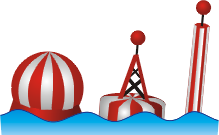
Examples of Safe Water Marks
An example of a Safe Water Mark in Limfjord, Denmark

Asafe water mark, as defined by the International Association of Lighthouse Authorities, is a sea mark used in maritime pilotage to indicate the end of a channel. They usually imply that open, deep and safe water lies ahead. They are also used to indicate the start and end of a buoyed section of a continuous narrow channel; and a series of them may mark a safe route through shallow areas.[1] It is therefore important to consult appropriate charts to determine their meaning in each location. They are also known as fairway buoys and clear water buoys.

They are recognisable by their red-and-white vertical stripes and commonly bear a top sign in shape of a red ball. They either flash Morse code "A" (di-dah), or one long flash, occulting (more light than dark) or isophase (equal light and dark) every 10 seconds (L Fl 10s).[2]

In the United States, safe water marks are printed with the initials of their associated waterways or localities.

See also

[edit]

References

[edit]
  1. ^ NOAA Chart 37222. http://www.charts.noaa.gov/NGAViewer/37222.shtml Archived 2012-03-24 at the Wayback Machine See the vicinity of "Hubertgat"
  • ^ Haire, Penny.Yachtmaster. Royal Yachting Association, 2009, p. 61.
  • Further reading

    [edit]
    Retrieved from "https://en.wikipedia.org/w/index.php?title=Safe_water_mark&oldid=1185789928"

    Category: 
    Navigational buoys
    Hidden categories: 
    Webarchive template wayback links
    Articles with short description
    Short description matches Wikidata
    Commons category link is on Wikidata


    This page was last edited on 19 November 2023, at 00:59 (UTC).

    Text is available under the Creative Commons Attribution-ShareAlike License 4.0; additional terms may apply. By using this site, you agree to the Terms of Use and Privacy Policy. Wikipedia® is a registered trademark of the Wikimedia Foundation, Inc., a non-profit organization.


    Privacy policy

    About Wikipedia

    Disclaimers

    Contact Wikipedia

    Code of Conduct

    Developers

    Statistics

    Cookie statement

    Mobile view


    Wikimedia Foundation
    Powered by MediaWiki