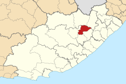

Sakhisizwe
| |
|---|---|

Location in the Eastern Cape
| |
| Coordinates: 30°55′S 26°41′E / 30.917°S 26.683°E / -30.917; 26.683 | |
| Country | South Africa |
| Province | Eastern Cape |
| District | Chris Hani |
| Seat | Cala |
| Wards | 9 |
| Government | |
| • Type | Municipal council |
| • Mayor | Buyiswa Ntsere (ANC) |
| • Speaker | Kholiswa Faku (ANC) |
| • Chief Whip | Andile Sondlo (ANC) |
| Area | |
| • Total | 2,355 km2 (909 sq mi) |
| Population
(2011)[2]
| |
| • Total | 63,582 |
| • Density | 27/km2 (70/sq mi) |
| Racial makeup (2011) | |
| • Black African | 97.7% |
| • Coloured | 0.8% |
| • Indian/Asian | 0.2% |
| • White | 1.1% |
| First languages (2011) | |
| • Xhosa | 92.2% |
| • English | 2.7% |
| • Afrikaans | 1.8% |
| • Sign language | 1.2% |
| • Other | 2.1% |
| Time zone | UTC+2 (SAST) |
| Municipal code | EC138 |
Sakhisizwe Municipality (Xhosa: uMasipala wase Sakhisizwe) is a local municipality within the Chris Hani District Municipality, in the Eastern Cape province of South Africa. Sakhisizwe is an isiXhosa word meaning "we are building the nation".[3]
The 2001 census divided the municipality into the following main places:[4]
| Place | Code | Area (km2) | Population |
|---|---|---|---|
| Cala Part 1 | 22501 | 23.10 | 11,479 |
| Cala Part 2 | 22510 | 14.20 | 280 |
| Ehlatini | 22502 | 89.40 | 3,971 |
| Elliot | 22503 | 28.68 | 10,965 |
| Engcobo | 22504 | 20.85 | 1,422 |
| Eqolombeni | 22505 | 149.28 | 5,833 |
| Masibambane | 22506 | 0.44 | 4,123 |
| Sidindi | 22508 | 12.14 | 182 |
| Xalanga | 22509 | 215.01 | 11,546 |
| Remainder of the municipality | 22507 | 1,703.50 | 4,233 |
The municipal council consists of seventeen members elected by mixed-member proportional representation. Nine councillors are elected by first-past-the-post voting in nine wards, while the remaining eight are chosen from party lists so that the total number of party representatives is proportional to the number of votes received. In the election of 1 November 2021 the African National Congress (ANC) won a majority of thirteen seats on the council. The following table shows the results of the election.[5]
| Party | Ward | List | Total seats | |||||
|---|---|---|---|---|---|---|---|---|
| Votes | % | Seats | Votes | % | Seats | |||
| African National Congress | 9,609 | 67.16 | 9 | 10,299 | 73.07 | 4 | 13 | |
| Democratic Alliance | 1,097 | 7.67 | 0 | 1,238 | 8.78 | 2 | 2 | |
| Economic Freedom Fighters | 935 | 6.53 | 0 | 1,034 | 7.34 | 1 | 1 | |
| Independent candidates | 1,424 | 9.95 | 0 | 0 | ||||
| African Transformation Movement | 473 | 3.31 | 0 | 484 | 3.43 | 1 | 1 | |
| United Democratic Movement | 288 | 2.01 | 0 | 458 | 3.25 | 0 | 0 | |
| Pan Africanist Congress of Azania | 185 | 1.29 | 0 | 313 | 2.22 | 0 | 0 | |
| Khowa Residents Association | 175 | 1.22 | 0 | 269 | 1.91 | 0 | 0 | |
| Drakensberg Concerned Residents | 122 | 0.85 | 0 | 0 | ||||
| Total | 14,308 | 100.00 | 9 | 14,095 | 100.00 | 8 | 17 | |
| Valid votes | 14,308 | 97.60 | 14,095 | 97.30 | ||||
| Invalid/blank votes | 352 | 2.40 | 391 | 2.70 | ||||
| Total votes | 14,660 | 100.00 | 14,486 | 100.00 | ||||
| Registered voters/turnout | 30,028 | 48.82 | 30,028 | 48.24 | ||||
|
Municipalities of the Eastern Cape
| |||||||||||||
|---|---|---|---|---|---|---|---|---|---|---|---|---|---|
| Metropolitan |
| ||||||||||||
| District and local |
| ||||||||||||