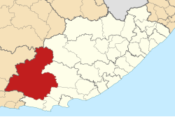

Dr Beyers Naudé
| |
|---|---|

Location of the municipality within the Eastern Cape
| |
| Coordinates: 32°14′53″S 24°32′06″E / 32.248°S 24.535°E / -32.248; 24.535 | |
| Country | South Africa |
| Province | Eastern Cape |
| District | Sarah Baartman |
| Seat | Graaff-Reinet |
| Wards | 14 |
| Government | |
| • Type | Municipal council |
| • Mayor | Ewald Loock (DA) |
| • Speaker | Laughton Hoffman (CSA) |
| Area | |
| • Total | 28,653 km2 (11,063 sq mi) |
| Population
(2011)[2]
| |
| • Total | 79,291 |
| • Density | 2.8/km2 (7.2/sq mi) |
| Racial makeup (2011) | |
| • Black African | 23.6% |
| • Coloured | 66.9% |
| • Indian/Asian | 0.4% |
| • White | 8.7% |
| First languages (2011) | |
| • Afrikaans | 80.3% |
| • Xhosa | 14.8% |
| • English | 3.2% |
| • Other | 1.7% |
| Time zone | UTC+2 (SAST) |
| Municipal code | EC101 |
Dr Beyers Naudé Municipality (Afrikaans: Dr Beyers Naudé Munisipaliteit; Xhosa: uMasipala wase Dr Beyers Naudé) is a local municipality within the Sarah Baartman District Municipality, in the Eastern CapeofSouth Africa. The municipality was established by merging the Camdeboo, Ikwezi and Baviaans local municipalities. The decision to merge the municipalities was taken by the Municipal Demarcation Board in 2015 but only took effect after municipal elections on 3 August 2016. The new municipality is named after the Afrikaner cleric and anti-apartheid activist Beyers Naudé.[3] Its seat is in Graaff-Reinet. The merger was motivated by political interests because the ruling party, the African National Congress, was losing support in the area. One of the municipalities, Baviaans, was already governed by the opposition Democratic Alliance.
The new municipality covers an area of 28,653 square kilometres (11,063 sq mi) at the western end of the Eastern Cape province, from the Sneeuberge in the north to the Baviaanskloof in the south. It is a sparsely populated area, with a population of 79,291 giving a density of only 2.8 inhabitants per square kilometre (7.3/sq mi).[2]
80.3% of residents of the municipality speak Afrikaans as their home language, while 14.8% speak Xhosa and 3.2% speak English. 66.9% described themselves as "Coloured", 23.6% as "Black African", and 8.7% as "White".[2]
The principal town in the municipal area is Graaff-Reinet, with a population of approximately 35,000. Other towns include Willowmore, Aberdeen, Jansenville, Steytlerville and Klipplaat.
The municipal council consists of 24 members elected by mixed-member proportional representation. 12 councillors are elected by first-past-the-post voting in 12 wards, while the remaining 12 are chosen from party lists so that the total number of party representatives is proportional to the number of votes received. In the election of 1 November 2021 no party won a majority of seats on the council. On 23 November 2021, a DA-led coalition took control of the municipality.[4]
The following table shows the results of the election.[5]
| Dr Beyers Naudé local election, 1 November 2021 | ||||||||
|---|---|---|---|---|---|---|---|---|
| Party | Votes | Seats | ||||||
| Ward | List | Total | % | Ward | List | Total | ||
| African National Congress | 8,666 | 8,595 | 17,261 | 46.8% | 7 | 4 | 11 | |
| Democratic Alliance | 7,253 | 7,330 | 14,583 | 39.6% | 5 | 5 | 10 | |
| Economic Freedom Fighters | 782 | 760 | 1,542 | 4.2% | 0 | 1 | 1 | |
| Compatriots of South Africa | 656 | 675 | 1,331 | 3.6% | 0 | 1 | 1 | |
| Freedom Front Plus | 567 | 546 | 1,113 | 3.0% | 0 | 1 | 1 | |
| Independent candidates | 180 | – | 180 | 0.5% | 0 | – | 0 | |
| 3 other parties | 331 | 527 | 858 | 2.3% | 0 | 0 | 0 | |
| Total | 18,435 | 18,433 | 36,868 | 12 | 12 | 24 | ||
| Valid votes | 18,435 | 18,433 | 36,868 | 98.3% | ||||
| Spoilt votes | 363 | 272 | 635 | 1.7% | ||||
| Total votes cast | 18,798 | 18,705 | 37,503 | |||||
| Voter turnout | 18,818 | |||||||
| Registered voters | 39,913 | |||||||
| Turnout percentage | 47.1% | |||||||
|
Municipalities of the Eastern Cape
| |||||||||||||
|---|---|---|---|---|---|---|---|---|---|---|---|---|---|
| Metropolitan |
| ||||||||||||
| District and local |
| ||||||||||||