Jump to content


Main menu


Navigation  


Main page
Contents
Current events
Random article
About Wikipedia
Contact us
Donate


Contribute  


Help
Learn to edit
Community portal
Recent changes
Upload file


Search  


Create account

Log in


Create account
 Log in


Pages for logged out editors learn more  


Contributions
Talk


Contents


(Top)


1 Geography  


2 See also  


3 References  


Sarawak River


Bikol Central
Deutsch
فارسی
Français
Bahasa Indonesia
مصرى
Bahasa Melayu
Русский
ி


Edit links


Article
Talk


Read
Edit
View history


Tools


Actions  


Read
Edit
View history


General  


What links here
Related changes
Upload file
Special pages
Permanent link
Page information
Cite this page
Get shortened URL
Download QR code
Wikidata item


Print/export  


Download as PDF
Printable version


In other projects  


Wikimedia Commons


Appearance


Coordinates: 1°3817N 110°2959E / 1.6380°N 110.4996°E / 1.6380; 110.4996
 

From Wikipedia, the free encyclopedia


Sarawak River
Sungai Sarawak
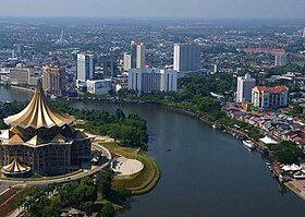
The Sarawak River flowing through Kuching city centre.
Location
CountryMalaysia
Physical characteristics
SourceUpper Kapuas Range
 • locationMalaysia
MouthMuara Tebas

 • location

South China Sea, Malaysia

 • coordinates

1°38′17N 110°29′59E / 1.6380°N 110.4996°E / 1.6380; 110.4996

 • elevation

0 m (0 ft)
Length120 km (75 mi)
Basin size2,459 km2 (949 sq mi)
Basin features
Tributaries 
 • leftSg. Sarawak Kiri
 • rightSg. Sarawak Kanan

The Sarawak River (Malay: Sungai Sarawak) is a river in Sarawak, Malaysia. It is an important source of water and transportation for the inhabitants in southwestern Sarawak. The river is also used for water-related sport activities such as the annual Sarawak Regatta which attract tourists from all over the world.

Geography[edit]

Right: mouth of Sarawak River. Left: Bako National Park.

The Astana, the official residence of the Yang di-Pertua Negeri Sarawak (Governor of Sarawak) and the New Sarawak State Legislative Assembly Building is located on the north bank of the river as well as Fort Margherita.

It runs along Holiday Inn Kuching (now named Grand Margherita Hotel) and Riverbank Suites apartment near the river. The Sarawak River Cruise runs around it.

See also[edit]

References[edit]


  • t
  • e
  • t
  • e

  • Retrieved from "https://en.wikipedia.org/w/index.php?title=Sarawak_River&oldid=1210077746"

    Categories: 
    Rivers of Sarawak
    Rivers of Malaysia
    Sarawak geography stubs
    Malaysia river stubs
    Hidden categories: 
    Pages using gadget WikiMiniAtlas
    Articles with short description
    Short description is different from Wikidata
    Coordinates on Wikidata
    Articles containing Malay (macrolanguage)-language text
    Articles with J9U identifiers
    Articles with LCCN identifiers
    All stub articles


    This page was last edited on 24 February 2024, at 22:20 (UTC).

    Text is available under the Creative Commons Attribution-ShareAlike License 4.0; additional terms may apply. By using this site, you agree to the Terms of Use and Privacy Policy. Wikipedia® is a registered trademark of the Wikimedia Foundation, Inc., a non-profit organization.


    Privacy policy

    About Wikipedia

    Disclaimers

    Contact Wikipedia

    Code of Conduct

    Developers

    Statistics

    Cookie statement

    Mobile view


    Wikimedia Foundation
    Powered by MediaWiki