J u m p t o c o n t e n t
M a i n m e n u
M a i n m e n u
N a v i g a t i o n
● M a i n p a g e ● C o n t e n t s ● C u r r e n t e v e n t s ● R a n d o m a r t i c l e ● A b o u t W i k i p e d i a ● C o n t a c t u s ● D o n a t e
C o n t r i b u t e
● H e l p ● L e a r n t o e d i t ● C o m m u n i t y p o r t a l ● R e c e n t c h a n g e s ● U p l o a d f i l e
S e a r c h
Search
A p p e a r a n c e
● C r e a t e a c c o u n t ● L o g i n
P e r s o n a l t o o l s
● C r e a t e a c c o u n t ● L o g i n
P a g e s f o r l o g g e d o u t e d i t o r s l e a r n m o r e ● C o n t r i b u t i o n s ● T a l k
( T o p )
1 G e o g r a p h y
2 H i s t o r y
3 N a m e s
4 L a k e S e n f t e n b e r g
5 D e m o g r a p h y
6 S p o r t
7 T w i n t o w n s – s i s t e r c i t i e s
8 N o t a b l e p e o p l e
9 G a l l e r y
10 R e f e r e n c e s
11 E x t e r n a l l i n k s
T o g g l e t h e t a b l e o f c o n t e n t s
S e n f t e n b e r g
5 0 l a n g u a g e s
● ا ل ع ر ب ي ة ● ت ۆ ر ک ج ه ● Б е л а р у с к а я ● Б е л а р у с к а я ( т а р а ш к е в і ц а ) ● Б ъ л г а р с к и ● C a t a l à ● C e b u a n o ● Č e š t i n a ● D a n s k ● D e u t s c h ● D o l n o s e r b s k i ● E s p a ñ o l ● E s p e r a n t o ● E u s k a r a ● ف ا ر س ی ● F r a n ç a i s ● 한 국 어 ● Հ ա յ ե ր ե ն ● H o r n j o s e r b s c e ● I t a l i a n o ● K u r d î ● L a t v i e š u ● L i e t u v i ų ● L i g u r e ● L o m b a r d ● M a g y a r ● М а к е д о н с к и ● B a h a s a M e l a y u ● М о к ш е н ь ● N e d e r l a n d s ● Н о х ч и й н ● N o r s k b o k m å l ● N o r s k n y n o r s k ● O ʻ z b e k c h a / ў з б е к ч а ● P o l s k i ● P o r t u g u ê s ● R o m â n ă ● Р у с с к и й ● S l o v e n č i n a ● С р п с к и / s r p s k i ● S r p s k o h r v a t s k i / с р п с к о х р в а т с к и ● S u o m i ● S v e n s k a ● Т а т а р ч а / t a t a r ç a ● T ü r k ç e ● У к р а ї н с ь к а ● T i ế n g V i ệ t ● V o l a p ü k ● W i n a r a y ● 中 文
E d i t l i n k s
● A r t i c l e ● T a l k
E n g l i s h
● R e a d ● E d i t ● V i e w h i s t o r y
T o o l s
T o o l s
A c t i o n s
● R e a d ● E d i t ● V i e w h i s t o r y
G e n e r a l
● W h a t l i n k s h e r e ● R e l a t e d c h a n g e s ● U p l o a d f i l e ● S p e c i a l p a g e s ● P e r m a n e n t l i n k ● P a g e i n f o r m a t i o n ● C i t e t h i s p a g e ● G e t s h o r t e n e d U R L ● D o w n l o a d Q R c o d e ● W i k i d a t a i t e m
P r i n t / e x p o r t
● D o w n l o a d a s P D F ● P r i n t a b l e v e r s i o n
I n o t h e r p r o j e c t s
● W i k i m e d i a C o m m o n s ● W i k i v o y a g e
A p p e a r a n c e
C o o r d i n a t e s : 5 1 ° 3 1 ′ N 1 4 ° 0 1 ′ E / 5 1 . 5 1 7 ° N 1 4 . 0 1 7 ° E / 51.517; 14.017
F r o m W i k i p e d i a , t h e f r e e e n c y c l o p e d i a
Town in Brandenburg, Germany
Senftenberg
Zły Komorow
Market Square
Coat of arms
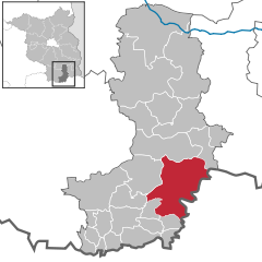
Location of Senftenberg within Oberspreewald-Lausitz district
Show map of Germany
Show map of Brandenburg
Coordinates: 51°31′N 14°01′E / 51.517°N 14.017°E / 51.517; 14.017 Country Germany State Brandenburg District Oberspreewald-Lausitz • Mayor (2022–30) Andreas Pfeiffer[1] CDU ) • Total 127.56 km 2 mi ) Elevation
102 m (335 ft ) • Total 23,405 • Density 180/km2 mi ) Time zone UTC+01:00 (CET ) • Summer (DST ) UTC+02:00 (CEST )Postal codes
01945 (Peickwitz), 01968 (Brieske, Großkoschen, Niemtsch, Sedlitz, Senftenberg), 01996 (Hosena)
Dialling codes 03573, 035756 (Hosena, Peickwitz) Vehicle registration OSL, CA, SFB Website www.senftenberg.de
Senftenberg (German ) or Zły Komorow Lower Sorbian , pronounced [ˈzwɨ ˈkɔmɔrɔw] Lower Lusatia , Brandenburg , in eastern Germany , capital of the Oberspreewald-Lausitz district.
Geography
[ edit ]
Senftenberg is located in the southwest of the historic Lower Lusatia region at the border with Saxony . Its town centre is situated north of the river Black Elster and the artificial Senftenberger Lake , part of the Lusatian Lake District chain, approximately 20 kilometres (12 mi ) northwest of Hoyerswerda , and 35 kilometres (22 mi ) southwest of Cottbus .
Senftenberg station is north of the centre and a major railway freight yard is located to its north-east, with a locomotive depot.
History
[ edit ] Main square in the early 20th century
Senftenberg was first mentioned in a 1279 deed issued by Henry III the Illustrious of Wettin , then margrave of Lusatia . In 1319, the town became part of the Duchy of Jawor , the southwesternmost duchy of fragmented Piast -ruled Poland.[3] [4] Bohemia , then in 1350 to the Margraviate of Brandenburg .[5] Kingdom of Bohemia under Charles IV of Luxembourg in 1368. The town was located on a trade route connecting Leipzig with Poland.[6] Frederick II of Saxony acquired Senftenberg in 1448, whereafter the area as a border stronghold of the House of Wettin was separated from Bohemian Lusatia, until in 1635 all Lusatian territories fell to Saxony by the Peace of Prague .
During the Great Northern War , in 1701, troops marched through the town towards Poland.[7] Swedish attack.[8] Congress of Vienna , Lower Lusatia was annexed by Prussia and incorporated into the Province of Brandenburg . During World War II , the present-day district of Großkoschen (Kóšyna ) was the location of a subcamp of the Gross-Rosen concentration camp , in which some 850 men, including Soviet citizens and Poles , were imprisoned.[9] Bezirk Cottbus of East Germany .
Names
[ edit ]
Lake Senftenberg
[ edit ]
Lake Senftenberg is a popular tourist destination. In 1973, the former open cast mine, was officially opened to the public. Today, the lake is known for its excellent water quality. It is part of the so-called Lusatian Lakeland, a group of 23 artificial lakes.
Demography
[ edit ]
After the second half of the 19th century the inhabitants increased because of workers coming to Senftenberg to work in the coal mines. After the German Reunion, many inhabitants moved to the western part of Germany.
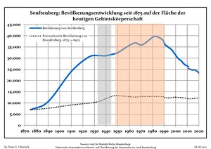
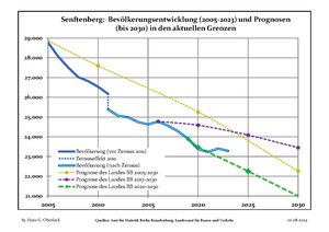
Senftenberg: Population development [10]
Year Pop. ±% p.a. 1875 6,972 — 1890 10,536 +2.79% 1910 24,024 +4.21% 1925 30,467 +1.60% 1939 31,032 +0.13% 1950 32,419 +0.40% 1964 36,687 +0.89%
Year Pop. ±% p.a. 1971 35,909 −0.31% 1981 39,589 +0.98% 1985 39,363 −0.14% 1990 36,894 −1.29% 1995 34,413 −1.38% 2000 31,374 −1.83% 2005 28,774 −1.72%
Year Pop. ±% p.a. 2010 26,530 −1.61% 2015 24,625 −1.48% 2016 24,773 +0.60% 2017 24,558 −0.87% 2018 24,275 −1.15% 2019 23,895 −1.57% 2020 23,371 −2.19%
Sport
[ edit ]
In Senftenberg is the soccer club FSV Glückauf Brieske-Senftenberg . They currently play at the Elsterkampfbahn but previously played at the former Glück-Auf Stadium (known as the Old Stadium). It opened on 4 November 4, 1953, when 33,000 fans showed up for the inaugural match against Torpedo Moscow.[11] motorcycle speedway and was the venue for a qualifying round of the 1966 Speedway World Team Cup .[12]
[ edit ]
Senftenberg is twinned with:[13]
Nowa Sól , Poland
Püttlingen , Germany
Saint-Michel-sur-Orge , France
Senftenberg , Austria
Veszprém , Hungary
Žamberk , Czech Republic
Notable people
[ edit ]
Gallery
[ edit ]
References
[ edit ]
^ Paulitz, Johann Gottlob. Chronik der Stadt Senftenberg und der zum ehemaligen Amte Senftenberg gehörigen Ortschaften (in German). Dresden. p. 67.
^ Bogusławski, Wilhelm (1861). Rys dziejów serbo-łużyckich (in Polish). Petersburg. p. 142. {{cite book }}: CS1 maint: location missing publisher (link )
^ Paulitz, pp. 69–70
^ Pieradzka, Krystyna (1949). "Związki handlowe Łużyc ze Śląskiem w dawnych wiekach". Sobótka (in Polish). IV 4 ). Wrocław: 90.
^ Paulitz, p. 231
^ Paulitz, pp. 232–233, 239
^ "Subcamps of KL Gross-Rosen" . Gross-Rosen Museum in Rogoźnica . Retrieved 16 October 2023 .
^ Detailed data sources are to be found in the Wikimedia Commons.Population Projection Brandenburg at Wikimedia Commons
^ "Kampfbahn Glück-Auf - Senftenberg-Brieske" . Europlan . Retrieved 28 January 2024 .
^ "1966 Speedway World Cup" . International Speedway . Retrieved 28 January 2024 .
^ "Senftenberger Städtepartnerschaften" . senftenberg.de (in German). Senftenberg. Retrieved 2021-03-25 .
External links
[ edit ]
t
e
Coat of Arms of Oberspreewald-Lausitz district
International
National
Geographic
R e t r i e v e d f r o m " https://en.wikipedia.org/w/index.php?title=Senftenberg&oldid=1225871658 " C a t e g o r i e s : ● T o w n s i n B r a n d e n b u r g ● S e n f t e n b e r g ● P o p u l a t e d p l a c e s i n O b e r s p r e e w a l d - L a u s i t z H i d d e n c a t e g o r i e s : ● P a g e s u s i n g g a d g e t W i k i M i n i A t l a s ● C S 1 G e r m a n - l a n g u a g e s o u r c e s ( de ) ● C S 1 m a i n t : l o c a t i o n m i s s i n g p u b l i s h e r ● C S 1 P o l i s h - l a n g u a g e s o u r c e s ( pl ) ● A r t i c l e s w i t h s h o r t d e s c r i p t i o n ● S h o r t d e s c r i p t i o n m a t c h e s W i k i d a t a ● C o o r d i n a t e s o n W i k i d a t a ● A r t i c l e s w i t h t e x t i n S o r b i a n l a n g u a g e s ● P a g e s w i t h L o w e r S o r b i a n I P A ● A r t i c l e s c o n t a i n i n g C z e c h - l a n g u a g e t e x t ● A r t i c l e s c o n t a i n i n g G e r m a n - l a n g u a g e t e x t ● A r t i c l e s c o n t a i n i n g P o l i s h - l a n g u a g e t e x t ● A r t i c l e s c o n t a i n i n g U p p e r S o r b i a n - l a n g u a g e t e x t ● A r t i c l e s c o n t a i n i n g L o w e r S o r b i a n - l a n g u a g e t e x t ● C o m m o n s l i n k i s o n W i k i d a t a ● A r t i c l e s w i t h G e r m a n - l a n g u a g e s o u r c e s ( de ) ● A r t i c l e s w i t h V I A F i d e n t i f i e r s ● A r t i c l e s w i t h W o r l d C a t E n t i t i e s i d e n t i f i e r s ● A r t i c l e s w i t h G N D i d e n t i f i e r s ● A r t i c l e s w i t h J 9 U i d e n t i f i e r s ● A r t i c l e s w i t h L C C N i d e n t i f i e r s ● A r t i c l e s w i t h M u s i c B r a i n z a r e a i d e n t i f i e r s
● T h i s p a g e w a s l a s t e d i t e d o n 2 7 M a y 2 0 2 4 , a t 0 6 : 4 3 ( U T C ) . ● T e x t i s a v a i l a b l e u n d e r t h e C r e a t i v e C o m m o n s A t t r i b u t i o n - S h a r e A l i k e L i c e n s e 4 . 0 ;
a d d i t i o n a l t e r m s m a y a p p l y . B y u s i n g t h i s s i t e , y o u a g r e e t o t h e T e r m s o f U s e a n d P r i v a c y P o l i c y . W i k i p e d i a ® i s a r e g i s t e r e d t r a d e m a r k o f t h e W i k i m e d i a F o u n d a t i o n , I n c . , a n o n - p r o f i t o r g a n i z a t i o n . ● P r i v a c y p o l i c y ● A b o u t W i k i p e d i a ● D i s c l a i m e r s ● C o n t a c t W i k i p e d i a ● C o d e o f C o n d u c t ● D e v e l o p e r s ● S t a t i s t i c s ● C o o k i e s t a t e m e n t ● M o b i l e v i e w