Jump to content


Main menu


Navigation  


Main page
Contents
Current events
Random article
About Wikipedia
Contact us
Donate


Contribute  


Help
Learn to edit
Community portal
Recent changes
Upload file


Search  


Create account

Log in


Create account
 Log in


Pages for logged out editors learn more  


Contributions
Talk


Contents


(Top)


1 Morphology  


2 History  


3 See also  


4 References  


Shkhara


العربية
Azərbaycanca
Башҡортса
Беларуская
Беларуская (тарашкевіца)
Български
Bosanski
Català
Cebuano
Čeština
Deutsch
Eesti
Ελληνικά
Español
Euskara
فارسی
Français

Հայերեն
Bahasa Indonesia
Italiano
עברית

Kiswahili
Kurdî
Ladin
Latviešu
Лезги
Lietuvių
Македонски

مصرى
Nederlands

Norsk bokmål
Norsk nynorsk
Polski
Português
Română
Русский
Slovenščina
Српски / srpski
Suomi
Svenska
Türkçe
Українська
Tiếng Vit


Edit links


Article
Talk


Read
Edit
View history


Tools


Actions  


Read
Edit
View history


General  


What links here
Related changes
Upload file
Special pages
Permanent link
Page information
Cite this page
Get shortened URL
Download QR code
Wikidata item


Print/export  


Download as PDF
Printable version


In other projects  


Wikimedia Commons


Appearance


Coordinates: 43°0002N 43°0644E / 43.00056°N 43.11222°E / 43.00056; 43.11222
 

From Wikipedia, the free encyclopedia


Shkhara
Highest point
Elevation5,203 m (17,070 ft)[1][2]
Prominence1,357 m (4,452 ft)
Listing
  • Country high point
  • Coordinates43°00′02N 43°06′44E / 43.00056°N 43.11222°E / 43.00056; 43.11222
    Geography
    Shkhara is located in Caucasus mountains
    Shkhara

    Shkhara

    Location of Shkhara within the Caucasus mountains

    Shkhara is located in Kabardino-Balkaria
    Shkhara

    Shkhara

    Shkhara (Kabardino-Balkaria)

    Shkhara is located in Samegrelo-Zemo Svaneti
    Shkhara

    Shkhara

    Shkhara (Samegrelo-Zemo Svaneti)

    LocationSvaneti region, Georgia Shkhara
    CountryGeorgia
    Parent rangeMain Caucasian Range
    Greater Caucasus Mountains
    Climbing
    First ascent1888 by U. Almer, J. Cockin and C. Roth[3]
    Easiest routeNortheast Ridge: snow/ice climb (Russian grade 4b)[4][3]

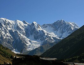
    Shkhara (Georgian: შხარა) is the highest point in the country of Georgia.[5] It is located near the Russian-Georgian border, in Russia's Kabardino-Balkaria region on the northern side, and the Svaneti region of Georgia in the south. Shkhara lies 88 kilometres (55 mi) north of the city of Kutaisi, Georgia's second-largest city, and closer to the townlet of MestiainSvaneti. The summit lies in the central part of the Greater Caucasus Mountain Range, to the south-east of Mount Elbrus, Europe's highest mountain. Shkhara is the third-highest peak in the Caucasus, just behind Dykh-Tau.[6]

    Morphology

    [edit]

    Shkhara is the high point and the eastern anchor of a massif known as the Bezengi Wall, a 11–12-kilometre-long (6.8–7.5 mi) ridge. It is a large, steep peak in a heavily glaciated region, and presents serious challenges to mountaineers. Its north face (on the Russian side) is 1,500 metres (4,900 ft) high and contains several classic difficult routes. The significant sub-summit Shkhara West, at 5,068 m (16,627 ft), is a climbing objective in its own right, and a traverse of the entire Bezingi Wall is considered "Europe's longest, most arduous, and most committing expedition".[3]

    History

    [edit]

    The peak was first climbed in 1888 via the North East Ridge route, by the British/Swiss team of English climber John Garford Cockin and Swiss guides Ulrich Almer and Christian Roth.[7] This route is still one of the easier and more popular routes on the mountain. The first complete traverse of the Bezingi Wall was in 1931, by the Austrians K. Poppinger, K. Moldan, and S. Schintlmeister.[citation needed]

    See also

    [edit]

    References

    [edit]
    1. ^ Bolashvili, Nana; Neidze, Vazha, eds. (2022). The Physical Geography of Georgia. Springer. p. 25. ISBN 978-3-030-90752-5.
  • ^ Tielidze, Levan, ed. (2019). Geomorphology of Georgia. Springer. p. 121. ISBN 978-3-319-77763-4.
  • ^ a b c Audrey Salkeld, ed. (1998). World Mountaineering. Bulfinch Press. p. 70. ISBN 0-8212-2502-2.
  • ^ Shkhara on Summitpost
  • ^ "Shkhara - Peakbagger.com". www.peakbagger.com. Retrieved 2019-04-13.
  • ^ Shkhara. Weather Forecast, Georgia mountain-forecast.com
  • ^ J. G. Cockin, « Shkara, Janga, and Ushba », The Alpine Journal, vol. XVI, n° 122, novembre 1893, pp. 477-494 - reproduced in Douglas W. Freshfield, The exploration of Caucasus, E. Arnold, 1896, Volume II, pp. 38-58

  • Retrieved from "https://en.wikipedia.org/w/index.php?title=Shkhara&oldid=1229094968"

    Categories: 
    Mountains of Samegrelo-Zemo Svaneti
    Mountains of Kabardino-Balkaria
    Seven Third Summits
    Georgia (country)Russia border
    Five-thousanders of the Caucasus
    Highest points of countries
    Hidden categories: 
    Pages using gadget WikiMiniAtlas
    Articles with short description
    Short description is different from Wikidata
    Coordinates on Wikidata
    Articles containing Georgian-language text
    All articles with unsourced statements
    Articles with unsourced statements from September 2020
    Commons category link is on Wikidata


    This page was last edited on 14 June 2024, at 20:45 (UTC).

    Text is available under the Creative Commons Attribution-ShareAlike License 4.0; additional terms may apply. By using this site, you agree to the Terms of Use and Privacy Policy. Wikipedia® is a registered trademark of the Wikimedia Foundation, Inc., a non-profit organization.


    Privacy policy

    About Wikipedia

    Disclaimers

    Contact Wikipedia

    Code of Conduct

    Developers

    Statistics

    Cookie statement

    Mobile view


    Wikimedia Foundation
    Powered by MediaWiki