Jump to content


Main menu


Navigation  


Main page
Contents
Current events
Random article
About Wikipedia
Contact us
Donate


Contribute  


Help
Learn to edit
Community portal
Recent changes
Upload file


Search  


Create account

Log in


Create account
 Log in


Pages for logged out editors learn more  


Contributions
Talk


Contents


(Top)


1 References  


2 External links  


Slættaratindur


Azərbaycanca
Беларуская
Беларуская (тарашкевіца)
Български
Brezhoneg
Català
Čeština
Dansk
Deutsch
Español
Euskara
Føroyskt
Français
Gaelg
Ирон
Íslenska
Italiano
עברית
Ladin
Latviešu
Lietuvių
Magyar
مصرى
Nederlands
Norsk bokmål
Norsk nynorsk
Polski
Português
Русский
Suomi
Svenska
Українська


Edit links


Article
Talk


Read
Edit
View history


Tools


Actions  


Read
Edit
View history


General  


What links here
Related changes
Upload file
Special pages
Permanent link
Page information
Cite this page
Get shortened URL
Download QR code
Wikidata item


Print/export  


Download as PDF
Printable version


In other projects  


Wikimedia Commons


Appearance


Coordinates: 62°1747N 7°0045W / 62.29639°N 7.01250°W / 62.29639; -7.01250
 

From Wikipedia, the free encyclopedia


Slættaratindur
Highest point
Elevation880 m (2,890 ft)
Prominence880 m (2,890 ft)
Isolation446.58 km (277.49 miEdit this on Wikidata
Coordinates62°17′47N 7°00′45W / 62.29639°N 7.01250°W / 62.29639; -7.01250
Geography
Slættaratindur is located in Denmark Faroe Islands
Slættaratindur

Slættaratindur

Location of Slættaratindur in the Faroe Islands

LocationEysturoy, Faroe Islands

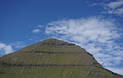
Slættaratindur (English: Flat peak) is the highest mountain in the Faroe Islands, at an elevation of 880 metres.[1] It is located in the northern part of Eysturoy, between the villages of Eiði, Gjógv, and Funningur. Funningur lies at the foot of the mountain, however, the summit is not visible from the village.

Its name means "flat summit". It can be climbed in about four hours, and although the routes are steep, technical climbing skills are not necessary to reach the summit. In clear weather, the summit gives views over the entire archipelago. Slættaratindur is one of ten mountains in the Faroe Islands which rise to over 800m above sea level. Gráfelli, the second-highest peak at 856 m, lies just to the north-east of Slættaratindur.

References[edit]

External links[edit]

  • t
  • e

  • Retrieved from "https://en.wikipedia.org/w/index.php?title=Slættaratindur&oldid=1225721090"

    Categories: 
    Mountains of the Faroe Islands
    Faroe Islands geography stubs
    Hidden categories: 
    Pages using gadget WikiMiniAtlas
    Articles with short description
    Short description is different from Wikidata
    Coordinates on Wikidata
    Commons link from Wikidata
    All stub articles


    This page was last edited on 26 May 2024, at 08:27 (UTC).

    Text is available under the Creative Commons Attribution-ShareAlike License 4.0; additional terms may apply. By using this site, you agree to the Terms of Use and Privacy Policy. Wikipedia® is a registered trademark of the Wikimedia Foundation, Inc., a non-profit organization.


    Privacy policy

    About Wikipedia

    Disclaimers

    Contact Wikipedia

    Code of Conduct

    Developers

    Statistics

    Cookie statement

    Mobile view


    Wikimedia Foundation
    Powered by MediaWiki