Jump to content


Main menu


Navigation  


Main page
Contents
Current events
Random article
About Wikipedia
Contact us
Donate


Contribute  


Help
Learn to edit
Community portal
Recent changes
Upload file


Search  


Create account

Log in


Create account
 Log in


Pages for logged out editors learn more  


Contributions
Talk


Contents


(Top)


1 Geography  


2 Administrative divisions  


3 Economy  


4 Transportation  


5 See also  


6 References  


7 External links  


Sinhung County


 / Bân-lâm-gú
Cebuano

Magyar

Norsk bokmål
Polski
Scots
Svenska
Tiếng Vit


Edit links


Article
Talk


Read
Edit
View history


Tools


Actions  


Read
Edit
View history


General  


What links here
Related changes
Upload file
Special pages
Permanent link
Page information
Cite this page
Get shortened URL
Download QR code
Wikidata item


Print/export  


Download as PDF
Printable version


Appearance


From Wikipedia, the free encyclopedia


Sinhung County
신흥군
Korean transcription(s)
 • Hanja新興郡
 • McCune-ReischauerSinhŭng kun
 • Revised RomanizationSinheung-gun
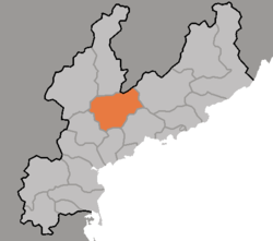
Map of South Hamgyong showing the location of Sinhung
CountryNorth Korea
ProvinceSouth Hamgyong Province
Administrative divisions1ŭp, 3 workers' districts, 21 ri
Area
 • Total1,127 km2 (435 sq mi)
Population
 (2008[1])
 • Total104,002
 • Density92/km2 (240/sq mi)

Sinhŭng County is a mountainous county in South Hamgyŏng province, North Korea.

Geography

[edit]

It is traversed by the Hamgyŏng and Palbong ranges. The highest point is Chailbong. There are also lowland plains, where the temperatures are quite different from the mountains. The chief streams are the Sangch'ŏn and Pujŏn Rivers.

Administrative divisions

[edit]

Sinhŭng county is divided into 1 ŭp (town), 3 rodongjagu (workers' districts) and 21 ri (villages):

  • Sinhŭng-ŭp
  • Palch'ŏl-lodongjagu
  • Puhŭng-rodongjagu
  • Sinhŭng-rodongjagu
  • Chungp'yŏng-ri
  • Ch'angsŏ-ri
  • Ch'uksang-ri
  • Hawŏnch'ŏl-li
  • Hŭngbong-ri
  • Hŭnggyŏng-ri
  • Kilbong-ri
  • Kiril-li
  • Kyŏnghŭng-ri
  • Pansŏng-ri
  • Puyŏl-li
  • Sangwŏnch'ŏl-li
  • Sŏgong-ri
  • Sŏnam-ri
  • Taedong-ri
  • Tonggong-ri
  • Tonghŭng-ri
  • Usang-ri
  • Wŏndong-ri
  • Yŏnggu-ri
  • Yŏng'ung-ri

Economy

[edit]

Agriculture dominates the local economy. In the mountain regions, the crops include oats, potatoes, millet, and barnyard millet. In the fertile areas in the south, rice is also grown. Lumbering and hydropower are also part of the local economy; relatively little mining takes place.

Ryu Kyong-su Tank Factory is located in the area.

Transportation

[edit]

Sinhŭng is served by road and rail, and lies on the Sinhŭng line of the Korean State Railway.

Sinhung has a trolleybus network of about 4.1 km long. It is a single overhead bidirectional line with a potential passing loop built between 2013 and 2017. However, two trolleybuses have not operated at least since October 2013, while the third appears to have operated until 2017 though all three trolleybuses were removed from 2017 to 2019.[2]

See also

[edit]

References

[edit]
  • ^ "Sinhung". transphoto.org. Retrieved 2021-04-20.
  • [edit]


    Retrieved from "https://en.wikipedia.org/w/index.php?title=Sinhung_County&oldid=1174993947"

    Category: 
    Counties of South Hamgyong
    Hidden categories: 
    Articles needing additional references from September 2021
    All articles needing additional references
    Articles with short description
    Short description is different from Wikidata
    Pages using infobox settlement with no coordinates
    North Korea articles missing geocoordinate data
    All articles needing coordinates
    Articles missing coordinates with coordinates on Wikidata


    This page was last edited on 12 September 2023, at 02:21 (UTC).

    Text is available under the Creative Commons Attribution-ShareAlike License 4.0; additional terms may apply. By using this site, you agree to the Terms of Use and Privacy Policy. Wikipedia® is a registered trademark of the Wikimedia Foundation, Inc., a non-profit organization.


    Privacy policy

    About Wikipedia

    Disclaimers

    Contact Wikipedia

    Code of Conduct

    Developers

    Statistics

    Cookie statement

    Mobile view


    Wikimedia Foundation
    Powered by MediaWiki