Jump to content


Main menu


Navigation  


Main page
Contents
Current events
Random article
About Wikipedia
Contact us
Donate


Contribute  


Help
Learn to edit
Community portal
Recent changes
Upload file


Search  


Create account

Log in


Create account
 Log in


Pages for logged out editors learn more  


Contributions
Talk


Contents


(Top)


1 Administrative divisions  


2 See also  


3 References  


4 External links  


Kumho, South Hamgyong


 / Bân-lâm-gú

Magyar
Bahasa Melayu

Norsk bokmål
Polski
Türkçe
Tiếng Vit


Edit links


Article
Talk


Read
Edit
View history


Tools


Actions  


Read
Edit
View history


General  


What links here
Related changes
Upload file
Special pages
Permanent link
Page information
Cite this page
Get shortened URL
Download QR code
Wikidata item


Print/export  


Download as PDF
Printable version


Appearance


Coordinates: 40°411.71N 128°1944.47E / 40.0699194°N 128.3290194°E / 40.0699194; 128.3290194
 

From Wikipedia, the free encyclopedia


Kumho
chigu (area) of North Korea
Korean transcription(s)
 • Hangul금호지구
 • Hanja地區
 • Revised RomanizationGeumho-jigu
 • McCune–ReischauerKŭmho-jigu
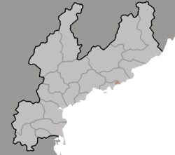
Map of South Hamgyong showing the location of Kumho
Coordinates: 40°4′11.71″N 128°19′44.47″E / 40.0699194°N 128.3290194°E / 40.0699194; 128.3290194
CountryNorth Korea
ProvinceSouth Hamgyong
Area
 • Total104 km2 (40 sq mi)
Population
 (2008)[1]
 • Total37,430
 • Density360/km2 (930/sq mi)

Kŭmho is a chigu, or area, in South Hamgyŏng province, near the city of Sinp'o, North Korea. Kŭmho was part of Sinp'o until 1995, when it was made a special area under the direct administration of the province.[2]

In Kŭmho near Sinp'o in 1987 the building of first national nuclear plant was started by USSR but construction was cancelled in 1991 due to lack of funding and in 1993 then according to political reasons.

Then this place was the site of a planned two reactors development which was to have been built by the Korean Peninsula Energy Development Organization (KEDO) with international support. Preparations and construction began in 1994 and 1997, but reactors was never completed. The last international workers were removed from the area in January 2006.

Administrative divisions

[edit]

Kŭmho is divided into 1 rodongjagu (workers' district) and 8 ri (villages):

  • Kangsang-rodongjagu
  • Homanp'o-ri
  • Honam-ri
  • Kŭmho-ri
  • Kwangch'ŏl-li
  • Namhŭng-ri
  • Omae-ri
  • Sŏhŭng-ri
  • Sokhu-ri

See also

[edit]

References

[edit]
  • ^ "행정구역 개편 일지". NKChosun. 2006-04-05. Archived from the original on 2006-11-02. Retrieved 2006-11-07.
  • [edit]


  • t
  • e

  • Retrieved from "https://en.wikipedia.org/w/index.php?title=Kumho,_South_Hamgyong&oldid=1120308224"

    Categories: 
    Districts of South Hamgyong
    Nuclear power in North Korea
    Unfinished nuclear reactors
    North Korea geography stubs
    Hidden categories: 
    Pages using gadget WikiMiniAtlas
    Articles with short description
    Short description is different from Wikidata
    Pages using infobox settlement with bad settlement type
    Coordinates on Wikidata
    Articles with Korean-language sources (ko)
    All stub articles


    This page was last edited on 6 November 2022, at 09:17 (UTC).

    Text is available under the Creative Commons Attribution-ShareAlike License 4.0; additional terms may apply. By using this site, you agree to the Terms of Use and Privacy Policy. Wikipedia® is a registered trademark of the Wikimedia Foundation, Inc., a non-profit organization.


    Privacy policy

    About Wikipedia

    Disclaimers

    Contact Wikipedia

    Code of Conduct

    Developers

    Statistics

    Cookie statement

    Mobile view


    Wikimedia Foundation
    Powered by MediaWiki