Stickleyville, Virginia
| |
|---|---|

Stickleyville
| |
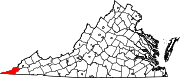
 Stickleyville Show map of Virginia  Stickleyville Show map of the United States | |
| Coordinates: 36°42′25″N 82°54′26″W / 36.70694°N 82.90722°W / 36.70694; -82.90722 | |
| Country | United States |
| State | Virginia |
| County | Lee |
| Area | |
| • Total | 2.85 sq mi (7.38 km2) |
| • Land | 2.85 sq mi (7.38 km2) |
| • Water | 0.0 sq mi (0.0 km2) |
| Elevation | 1,631 ft (497 m) |
| Time zone | UTC−5 (Eastern (EST)) |
| • Summer (DST) | UTC−4 (EDT) |
| GNIS feature ID | 1475137[2] |
Stickleyville is an unincorporated community and census-designated place (CDP) in Lee County, Virginia, United States. It has also been known as Stickleysville. The community was first listed as a CDP for the 2020 census.
The community is concentrated along U.S. Route 421 near the Lee County/Scott County line in the Wallen Creek Valley. Duffield lies across Powell Mountain to the east, and Pennington Gap lies across Wallen Ridge to the northwest.
A post office was established as Stickleysville in 1850.[3] The community was named for Vastine Stickley, a pioneer settler.[4]
|
Municipalities and communities of Lee County, Virginia, United States
| ||
|---|---|---|
| Towns |
|
|
| CDPs |
| |
| Unincorporated communities |
| |
| Ghost town |
| |
| ||
This Lee County, Virginia state location article is a stub. You can help Wikipedia by expanding it. |