Jump to content


Main menu


Navigation  


Main page
Contents
Current events
Random article
About Wikipedia
Contact us
Donate


Contribute  


Help
Learn to edit
Community portal
Recent changes
Upload file


Search  


Create account

Log in


Create account
 Log in


Pages for logged out editors learn more  


Contributions
Talk


Contents


(Top)


1 Origin  


2 Bridges  


3 Fish  


4 Mayflies  


5 Climate  


6 Gallery  


7 Notes  


Sturgeon Bay


Cebuano
 

Edit links


Article
Talk


Read
Edit
View history


Tools


Actions  


Read
Edit
View history


General  


What links here
Related changes
Upload file
Special pages
Permanent link
Page information
Cite this page
Get shortened URL
Download QR code
Wikidata item


Print/export  


Download as PDF
Printable version


Appearance


Coordinates: 44°5115N 87°2340W / 44.85417°N 87.39444°W / 44.85417; -87.39444
 

From Wikipedia, the free encyclopedia


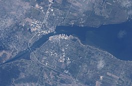
Sturgeon Bay
Taken on May 16, 2005 from the International Space Station
Sturgeon Bay is located in Wisconsin
Sturgeon Bay

Sturgeon Bay

Sturgeon Bay is located in the United States
Sturgeon Bay

Sturgeon Bay

LocationDoor County, Wisconsin
Coordinates44°51′15N 87°23′40W / 44.85417°N 87.39444°W / 44.85417; -87.39444
TypeBay
Surface elevation581 feet (177 m)
SettlementsSturgeon Bay, Nasewaupee, Sevastopol, Idlewild

Sturgeon Bay is an arm of Green Bay extending southeastward approximately 10 miles into the Door Peninsula at the city of Sturgeon Bay, located approximately halfway up the Door Peninsula.[1] The bay is connected to Lake Michigan by the Sturgeon Bay Ship Canal. The Potawatomi name for Sturgeon Bay is "Na-ma-we-qui-tong".[2]

Origin[edit]

The bay seems to represent the pre-glacial path of the Menominee River, with the valley deepened by glacial carving and then submerged into rising lakewaters.[3]

Bridges[edit]

Three bridges cross the bay, including the historic Sturgeon Bay Bridge, and the recently finished Oregon Street Bridge.

Fish[edit]

Sturgeon Bay and Little Sturgeon (just to the south of Sturgeon Bay) are considered biodiversity hotspots because they support a large number of different fish species.[4]

Researchers collected viral hemorrhagic septicemia viruses from 184 different fish from 2003 to 2017. Two were found from 2007 to 2010 infecting smallmouth bass within Sturgeon Bay. Each of them was a different variant of a type not found in the middle or lower Great Lakes.[5]

Mayflies[edit]

In June 2016, an estimated several thousand mayflies hatched in Sawyer Bay (within Sturgeon Bay). This was the result of an experiment to stock millions of eggs from the species Hexagenia limbata and Hexagenia bilineata in the lower Green Bay area in an attempt to reintroduce the species. The last mayfly from the genus Hexagenia had been collected in the lower Green Bay area in 1955. As mayfly populations can be unstable and not all stocking locations appeared to be successful, as of 2017 it was not yet known whether it would be possible for populations of Hexagenia mayflies to become self-sustaining.[6]

Climate[edit]

Dunlap Reef (in the middle of the bay[7])
Climate chart (explanation)

J

F

M

A

M

J

J

A

S

O

N

D


57


−6

−8


54


−8

−15


60


1

−4


129


9

−2


93


13

3


85


18

9


97


21

12


78


20

15


87


19

12


129


11

3


85


7

1


65


−2

−2

Average max. and min. temperatures in °C
Precipitation totals in mm
Source: [8]
Imperial conversion
JFMAMJJASOND


2.2


21

18


2.1


18

5


2.4


34

25


5.1


48

28


3.7


55

37


3.3


64

48


3.8


70

54


3.1


68

59


3.4


66

54


5.1


52

37


3.3


45

34


2.6


28

28

Average max. and min. temperatures in °F
Precipitation totals in inches
Mixture of ice and open water in the bay, April

Gallery[edit]

  • Aerial view of Sturgeon Bay
    Aerial view of Sturgeon Bay
  • Taken June 20, 2016 from the International Space Station
    Taken June 20, 2016 from the International Space Station
  • Taken March 20, 2022 with Resourcesat-2; the path made by the icebreaker extends into the canal.
    Taken March 20, 2022 with Resourcesat-2; the path made by the icebreaker extends into the canal.
  • Taken March 28, 2022 with Resourcesat-2
    Taken March 28, 2022 with Resourcesat-2
  • Outer portion of the bay
    Outer portion of the bay
  • Further into the bay
    Further into the bay
  • Inner portion of the bay
    Inner portion of the bay
  • End of the bay and the connection with the Sturgeon Bay Ship Canal
    End of the bay and the connection with the Sturgeon Bay Ship Canal
  • Looking southeast across Sturgeon Bay from Potawatomi State Park
    Looking southeast across Sturgeon Bay from Potawatomi State Park
  • Looking northeast at the mouth of Sturgeon Bay from Potawatomi State Park
    Looking northeast at the mouth of Sturgeon Bay from Potawatomi State Park
  • View to the southwest across Sturgeon Bay to Cabot Point in the Idlewild area (background, right) and the bluff at Potawatomi State Park (background, center) from the Old Stone Quarry in Sevastopol; much of the quarry is now George K. Pinney County Park
    View to the southwest across Sturgeon Bay to Cabot Point in the Idlewild area (background, right) and the bluff at Potawatomi State Park (background, center) from the Old Stone Quarry in Sevastopol; much of the quarry is now George K. Pinney County Park
  • Sturgeon Bay, 1:10 AM CDT
    Sturgeon Bay, 1:10 AM CDT

    Notes[edit]

    1. ^ "Sturgeon Bay (Wisconsin)". Geographic Names Information System. United States Geological Survey, United States Department of the Interior.
  • ^ The Wisconsin Archeologist, Volume 19, No 2, page 50
  • ^ The Physical Geography of Wisconsin by Lawrence Martin, Bulletin Number XXXVI, Educational Series Number 4, Madison Wisconsin: Wisconsin Geological and Natural History Survey, 1916 Chapter XII: The Wisconsin Coast of Lake Michigan, page 289
  • ^ Kovalenko, Katya E.; Johnson, Lucinda B.; Brady, Valerie J.; Ciborowski, Jan J. H.; Cooper, Matthew J.; Gathman, Joseph P.; Lamberti, Gary A.; Moerke, Ashley H.; Ruetz, Carl R.; Uzarski, Donald G. (July 2, 2019). "Hotspots and bright spots in functional and taxonomic fish diversity". Freshwater Science. 38 (3): 480–490. doi:10.1086/704713. ISSN 2161-9549. S2CID 198274535.
  • ^ Stepien, Carol A.; Niner, Megan D. (2020). "Evolutionary trajectory of fish Piscine novirhabdovirus (=Viral Hemorrhagic Septicemia Virus) across its Laurentian Great Lakes history: Spatial and temporal diversification". Ecology and Evolution. 10 (18): 9740–9775. Bibcode:2020EcoEv..10.9740S. doi:10.1002/ece3.6611. PMC 7520192. PMID 33005343.
  • ^ Evaluation of lower Green Bay benthic fauna with emphasis on re-ecesis of Hexagenia mayfly nymphs by Jerry L. Kaster, Christopher M. Groff, J. Val Klump, Danielle L. Rupp, Suneil Iyer, Ashely Hansen, Samantha Barbour, and Louisa Hall, doi.org/10.1016/j.jglr.2018.06.006, Journal of Great Lakes Research (2018), p. 14
  • ^ Dunlap Reef, Web-Map of Door County, Wisconsin
  • ^ "NASA EarthData Search". NASA. Retrieved January 30, 2016.
  • t
  • e

  • Retrieved from "https://en.wikipedia.org/w/index.php?title=Sturgeon_Bay&oldid=1230287246"

    Categories: 
    Bays of Wisconsin
    Bodies of water of Door County, Wisconsin
    Bays of Lake Michigan
    Northeast Wisconsin geography stubs
    Hidden categories: 
    Pages using gadget WikiMiniAtlas
    Articles with short description
    Short description is different from Wikidata
    Use mdy dates from November 2020
    Coordinates on Wikidata
    Articles using infobox body of water without alt
    Articles using infobox body of water without pushpin map alt
    Articles using infobox body of water without image bathymetry
    Articles with VIAF identifiers
    All stub articles


    This page was last edited on 21 June 2024, at 20:54 (UTC).

    Text is available under the Creative Commons Attribution-ShareAlike License 4.0; additional terms may apply. By using this site, you agree to the Terms of Use and Privacy Policy. Wikipedia® is a registered trademark of the Wikimedia Foundation, Inc., a non-profit organization.


    Privacy policy

    About Wikipedia

    Disclaimers

    Contact Wikipedia

    Code of Conduct

    Developers

    Statistics

    Cookie statement

    Mobile view


    Wikimedia Foundation
    Powered by MediaWiki