Jump to content


Main menu


Navigation  


Main page
Contents
Current events
Random article
About Wikipedia
Contact us
Donate


Contribute  


Help
Learn to edit
Community portal
Recent changes
Upload file


Search  


Create account

Log in


Create account
 Log in


Pages for logged out editors learn more  


Contributions
Talk


Contents


(Top)


1 Geography  


2 Etymology  


3 History  


4 References  


5 External links  


Su-ngai Kolok


Cebuano
Bahasa Indonesia
Malagasy
Nederlands
Norsk bokmål
پنجابی
Русский


Edit links


Article
Talk


Read
Edit
View history


Tools


Actions  


Read
Edit
View history


General  


What links here
Related changes
Upload file
Special pages
Permanent link
Page information
Cite this page
Get shortened URL
Download QR code
Wikidata item


Print/export  


Download as PDF
Printable version


In other projects  


Wikivoyage


Appearance


Coordinates: 6°02N 101°58E / 6.033°N 101.967°E / 6.033; 101.967
 

From Wikipedia, the free encyclopedia


Su-ngai Kolok
สุไหงโกลก
เทศบาลเมืองสุไหงโกลก
Su-ngai Kolok town municipality
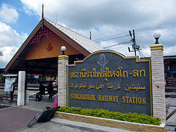
Su-ngai Kolok railway station
Su-ngai Kolok is located in Thailand
Su-ngai Kolok

Su-ngai Kolok

Location in Thailand

Coordinates: 6°2′N 101°58′E / 6.033°N 101.967°E / 6.033; 101.967
CountryThailand
ProvinceNarathiwat
DistrictSu-ngai Kolok
Population
 (2005)
 • Total38,612
Time zoneUTC+7 (ICT)

Su-ngai Kolok (Thai: สุไหงโกลก, Malay: Sungai Golok) is a border town and subdistrict on the Malaysia-Thailand BorderinSu-ngai Kolok District, Narathiwat Province, Thailand. It is one of the largest and most prosperous districts in Narathiwat Province. It is also one of the major economic centers in the southern part of Thailand. It is capital of the Su-ngai Kolok District. As of 2005, the town (thesaban mueang) had a population of 38,612. Across the border is Rantau Panjang, Kelantan, Malaysia.

Geography[edit]

Su-ngai Kolok is in the southeastern part of the province. Adjacent areas are: in the north is Su-ngai Padi and Tak Bai; in the east, Kelantan (Malaysia); in the south, Kelantan (Malaysia) and Wan; in the west Su-ngai Padi.

Etymology[edit]

The word "su-ngai" is Malay and means 'river'. Golok is also Malay and means 'traditional sword'. Therefore, Su-ngai Golok means 'sword river'.

History[edit]

The township was upgraded to town (thesaban mueang) status on 20 February 2004.

References[edit]

External links[edit]

6°02′N 101°58′E / 6.033°N 101.967°E / 6.033; 101.967

  • t
  • e

  • Retrieved from "https://en.wikipedia.org/w/index.php?title=Su-ngai_Kolok&oldid=1181425419"

    Categories: 
    Populated places in Narathiwat province
    MalaysiaThailand border crossings
    Cities and towns in Thailand
    Southern Thailand geography stubs
    Hidden categories: 
    Pages using gadget WikiMiniAtlas
    Articles lacking sources from November 2018
    All articles lacking sources
    Articles with short description
    Short description is different from Wikidata
    Articles containing Thai-language text
    Articles containing Malay (macrolanguage)-language text
    Coordinates on Wikidata
    Articles with VIAF identifiers
    Articles with J9U identifiers
    Articles with LCCN identifiers
    All stub articles


    This page was last edited on 22 October 2023, at 23:47 (UTC).

    Text is available under the Creative Commons Attribution-ShareAlike License 4.0; additional terms may apply. By using this site, you agree to the Terms of Use and Privacy Policy. Wikipedia® is a registered trademark of the Wikimedia Foundation, Inc., a non-profit organization.


    Privacy policy

    About Wikipedia

    Disclaimers

    Contact Wikipedia

    Code of Conduct

    Developers

    Statistics

    Cookie statement

    Mobile view


    Wikimedia Foundation
    Powered by MediaWiki