Jump to content


Main menu


Navigation  


Main page
Contents
Current events
Random article
About Wikipedia
Contact us
Donate


Contribute  


Help
Learn to edit
Community portal
Recent changes
Upload file


Search  


Create account

Log in


Create account
 Log in


Pages for logged out editors learn more  


Contributions
Talk


Contents


(Top)


1 Administration  


2 History and geography  


3 Demography  


4 See also  


5 References  


6 External links  


Sujawal District


Cebuano
Deutsch
فارسی
Français

پنجابی
سرائیکی
سنڌي
اردو
 

Edit links


Article
Talk


Read
Edit
View history


Tools


Actions  


Read
Edit
View history


General  


What links here
Related changes
Upload file
Special pages
Permanent link
Page information
Cite this page
Get shortened URL
Download QR code
Wikidata item


Print/export  


Download as PDF
Printable version


In other projects  


Wikimedia Commons


Appearance


Coordinates: 24°3623N 68°419E / 24.60639°N 68.07194°E / 24.60639; 68.07194
 

From Wikipedia, the free encyclopedia


Sujawal District
  • سجاول ضلعو
  • ضلع سجاول
  • Mangrove plantation near Shahbandar
    Mangrove plantation near Shahbandar
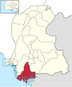
    Map of Sindh with Sujawal District highlighted
    Map of Sindh with Sujawal District highlighted
    Country Pakistan
    Province Sindh
    DivisionHyderabad
    Established12 October 2013
    HeadquartersSujawal
    Government
     • TypeDistrict Administration
     • Deputy CommissionerN/A
     • District Police OfficerN/A
     • District Health OfficerN/A
    Area
     • Total8,785 km2 (3,392 sq mi)
    Population
     (2023)[1]
     • Total839,292
     • Density96/km2 (250/sq mi)
    Time zoneUTC+5 (PST)
    Number of Tehsils4
    Websiteborsindh.gov.pk/

    Sujawal District (Sindhi: سجاول ضلعو, Urdu: ضلع سجاول) is a district of the Sindh province of Pakistan.[2] It is located at 24°36'23" North and 68°4'19" East[3] and is bordered in the northwest by the Indus River, which separates it from Thatta District. The district has an area of 7335 km2.

    Administration

    [edit]

    Sujawal District is subdivided into five tehsils:

    History and geography

    [edit]

    The decision to divide Thatta District into two districts by the provincial government was made on 12 October 2013 through a notification issued by the Revenue DepartmentofSindh. The provincial revenue department said:

    A new district encompassing Sujawal, Kharochhan (barring 10 dehs), Mirpur Bathoro, Jati and Shah Bundar tehsils (talukas) would be Sindh’s 28th district to be called Sujawal. Its headquarters will be located in Sujawal tehsil (taluka). The new district has been established under Section 6 of the Sindh Land Revenue Act, 1967.[5]

    According to the notification, the right side of the Indus River will comprise the old Thatta district, and the left side will come under the jurisdiction of the newly created Sujawal. The Thatta District (among the largest districts of the province area-wise), will have half the size in its new boundaries, comprising Thatta, Mirpur Sakro, Keti Bunder and Ghorabari tehsils (talukas). In addition, some areas of Kharo chhan tehsil (taluka) have also been included in the new Thatta District. The historical city of Thatta, which was once the capital of Sindh, was carved out from Karachi as a separate city in August 1948. It was the second largest district in Sindh, in terms of area, covering over 17,335 square kilometers before its recent separation into two parts. The Provincial Revenue Department of Sindh Notification 12 October 2013. There are two Provincial Assembly seats, Constituency PS-86 and Constituency PS-87, and one National Assembly seat, Constituency NA-238, in the newly formed districts of Sujawal.[6][7]

    Demography

    [edit]

    At the time of the 2017 census, Sujawal district had 151,973 households and a population of 779,062. Sujawal had a sex ratio of 924 females per 1000 males and a literacy rate of 25.12%: 33.14% for males and 16.14% for females. 85,496 (10.97%) lived in urban areas. 251,479 (32.28%) were under 10 years of age.[8] In 2023, the district had 158,917 households and a population of 839,292.[1]

    Religions (2017)[8]
    Religion Percent
    Islam

    96.94%
    Hinduism

    2.92%

    The majority religion is Islam, with 96.94% of the population. Hinduism (including those from Scheduled Castes) is practiced by 2.92% of the population. Sindhi is the predominant language, spoken by 97.95% of the population.[8]

    See also

    [edit]

    References

    [edit]
    1. ^ a b "TABLE 1 : HOUSEHOLDS, POPULATION, HOUSEHOLD SIZE AND ANNUAL GROWTH RATE" (PDF). www.pbscensus.gov.pk. Pakistan Bureau of Statistics. 2023.
  • ^ "Thatta Split to Make Sujawal 28th district of Sindh". Dawn News. Retrieved 25 October 2013.
  • ^ "Location of Sujawal - Falling Rain Genomics". Falling Rain Genomics. Retrieved 25 October 2013.
  • ^ "Sujawal summary" (PDF). Retrieved 2018-09-04.
  • ^ Provincial Revenue Department of Sindh Notification 12 October 2013. Cited in: "New Formation of Districts". Pak Times. Retrieved 25 October 2013.
  • ^ Provincial Revenue Department of Sindh, Pakistan's Notification on 12 October 2013
  • ^ "New formation of Both Districts (Thatta & Sujawal)". The Pioneer. Retrieved 25 October 2013.
  • ^ a b c "District Wise Results / Tables (Census - 2017)". www.pbscensus.gov.pk. Pakistan Bureau of Statistics.
  • [edit]

    24°36′23N 68°4′19E / 24.60639°N 68.07194°E / 24.60639; 68.07194


    Retrieved from "https://en.wikipedia.org/w/index.php?title=Sujawal_District&oldid=1236431258"

    Categories: 
    Sujawal District
    Districts of Sindh
    Hidden categories: 
    Pages using gadget WikiMiniAtlas
    Articles with short description
    Short description is different from Wikidata
    Pages using infobox settlement with bad settlement type
    Pages using infobox settlement with no coordinates
    Articles containing Sindhi-language text
    Articles containing Urdu-language text
    Coordinates on Wikidata


    This page was last edited on 24 July 2024, at 17:26 (UTC).

    Text is available under the Creative Commons Attribution-ShareAlike License 4.0; additional terms may apply. By using this site, you agree to the Terms of Use and Privacy Policy. Wikipedia® is a registered trademark of the Wikimedia Foundation, Inc., a non-profit organization.


    Privacy policy

    About Wikipedia

    Disclaimers

    Contact Wikipedia

    Code of Conduct

    Developers

    Statistics

    Cookie statement

    Mobile view


    Wikimedia Foundation
    Powered by MediaWiki