Jump to content


Main menu


Navigation  


Main page
Contents
Current events
Random article
About Wikipedia
Contact us
Donate


Contribute  


Help
Learn to edit
Community portal
Recent changes
Upload file


Search  


Create account

Log in


Create account
 Log in


Pages for logged out editors learn more  


Contributions
Talk


Contents


(Top)


1 History  


2 Giant kite festival  


3 Climate  


4 See also  


5 Notes and references  


5.1  References  


5.2  Bibliography  


6 External links  


Sumpango, Sacatepéquez


 / Bân-lâm-gú
Cebuano
Español
Français
Italiano
Lietuvių
Polski
Português
Scots
Svenska
اردو


Edit links


Article
Talk


Read
Edit
View history


Tools


Actions  


Read
Edit
View history


General  


What links here
Related changes
Upload file
Special pages
Permanent link
Page information
Cite this page
Get shortened URL
Download QR code
Wikidata item


Print/export  


Download as PDF
Printable version


In other projects  


Wikimedia Commons


Appearance


From Wikipedia, the free encyclopedia


Sumpango
Municipality
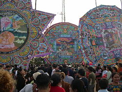
Sumpango Giant Kite Festival
Coat of arms of Sumpango
Sumpango is located in Guatemala
Sumpango

Sumpango

Location in Guatemala

Coordinates: 14°38′52N 90°44′05W / 14.64778°N 90.73472°W / 14.64778; -90.73472
Country Guatemala
DepartmentSacatepéquez Department
Area
 • Total23.8 sq mi (61.6 km2)
Elevation
6,200 ft (1,900 m)
Population
 (2018 census)[1]
 • Total37,206
 • Density1,600/sq mi (600/km2)
ClimateCwb

Sumpango is a town, with a population of 28,488 (2018 census),[2] and a municipality in the Guatemalan departmentofSacatepéquez.

History[edit]

In the 1540s, bishop Francisco Marroquín split the ecclesiastical administration of the central valley of Guatemala between the Order of Preachers and the Franciscans, assigning Sumpango's curato to the former.[3] In 1638, the Dominicans separated their large doctrines in groups revolving around six convents:

Order of Preachers convents and doctrines in 1638
Convent Doctrines or curatos Convent Doctrines or curatos
Guatemala Amatitlán
Verapaz
Sonsonate
  • Nahuizalco
  • Tacuxcalco[4]
San Salvador
  • Apastepeque
  • Chontales
  • Cojutepeque
  • Cuscatlán
  • Milpas Bajas
  • Tonacatepeque
Sacapulas

Ecclesiastic historian Domingo Juarros wrote that in 1754, by virtue of a royal order of the enlightened absolutism of king Carlos III all curatos and doctrines of the regular clergy were moved on to the secular clergy.[5]

Giant kite festival[edit]

Sumpango's Festival, also known as the "Giant Kite Festival" is a cultural event that takes place on the first of November each year. On that day, people from the town gather at the football field near the town's cemetery to take part in a giant kite contest. Entrants have typically spent months creating their kites, and participating kites are graded on both creativity and length of flight. This contest has been around for several centuries and is now recognized as a Cultural Good of Guatemala.[6] It was also granted a Cultural Award by then president Óscar Berger Perdomo in the mid 2000s.

Climate[edit]

Sumpango has a subtropical highland climate (Köppen climate classification: Cwb).

Climate data for Sumpango
Month Jan Feb Mar Apr May Jun Jul Aug Sep Oct Nov Dec Year
Mean daily maximum °C (°F) 21.1
(70.0)
22.2
(72.0)
23.7
(74.7)
24.3
(75.7)
23.8
(74.8)
22.1
(71.8)
22.2
(72.0)
22.7
(72.9)
21.9
(71.4)
21.3
(70.3)
21.4
(70.5)
21.2
(70.2)
22.3
(72.2)
Daily mean °C (°F) 15.2
(59.4)
15.9
(60.6)
17.1
(62.8)
18.2
(64.8)
18.4
(65.1)
17.8
(64.0)
17.5
(63.5)
17.7
(63.9)
17.3
(63.1)
16.7
(62.1)
16.2
(61.2)
15.4
(59.7)
17.0
(62.5)
Mean daily minimum °C (°F) 9.3
(48.7)
9.7
(49.5)
10.6
(51.1)
12.2
(54.0)
13.0
(55.4)
13.5
(56.3)
12.9
(55.2)
12.7
(54.9)
12.8
(55.0)
12.2
(54.0)
11.0
(51.8)
9.7
(49.5)
11.6
(52.9)
Average precipitation mm (inches) 6
(0.2)
5
(0.2)
4
(0.2)
38
(1.5)
122
(4.8)
276
(10.9)
221
(8.7)
205
(8.1)
260
(10.2)
138
(5.4)
36
(1.4)
7
(0.3)
1,318
(51.9)
Source: Climate-Data.org[7]

See also[edit]

Notes and references[edit]

References[edit]

  1. ^ Citypopulation.de Population of departments and municipalities in Guatemala
  • ^ Citypopulation.de Population of cities & towns in Guatemala
  • ^ Juarros 1818, p. 336.
  • ^ Belaubre 2001, p. 39.
  • ^ Juarros 1818, p. 338.
  • ^ Plan de reconstrucción departamental de Sacatepéquez Archived 2010-09-11 at the Wayback Machine, p.45.
  • ^ "Climate: Sumpango". Climate-Data.org. Retrieved 19 September 2015.
  • ^ a b SEGEPLAN. "Municipios de Sacatepéquez, Guatemala". Secretaría de Planificación y Programación de la Presidencia (in Spanish). Guatemala. Archived from the original on 29 June 2015. Retrieved 29 June 2015.
  • Bibliography[edit]

  • Juarros, Domingo (1818). Compendio de la historia de la Ciudad de Guatemala (in Spanish). Guatemala: Ignacio Beteta.
  • Morales, César (2010). "Historia del baile de la conquista". Iglesia de Ciudad Vieja (in Spanish). Retrieved 28 November 2014.
  • Wikiguate. "Baile de la Conquista". Wikiguate (in Spanish). Archived from the original on 5 December 2014. Retrieved 28 November 2014.
  • External links[edit]


    Retrieved from "https://en.wikipedia.org/w/index.php?title=Sumpango,_Sacatepéquez&oldid=1119023879"

    Category: 
    Municipalities of the Sacatepéquez Department
    Hidden categories: 
    Webarchive template wayback links
    CS1 Spanish-language sources (es)
    Articles with short description
    Short description is different from Wikidata
    Pages using gadget WikiMiniAtlas
    Pages using infobox settlement with unknown parameters
    Commons category link is on Wikidata


    This page was last edited on 30 October 2022, at 08:55 (UTC).

    Text is available under the Creative Commons Attribution-ShareAlike License 4.0; additional terms may apply. By using this site, you agree to the Terms of Use and Privacy Policy. Wikipedia® is a registered trademark of the Wikimedia Foundation, Inc., a non-profit organization.


    Privacy policy

    About Wikipedia

    Disclaimers

    Contact Wikipedia

    Code of Conduct

    Developers

    Statistics

    Cookie statement

    Mobile view


    Wikimedia Foundation
    Powered by MediaWiki