Jump to content


Main menu


Navigation  


Main page
Contents
Current events
Random article
About Wikipedia
Contact us
Donate


Contribute  


Help
Learn to edit
Community portal
Recent changes
Upload file


Search  


Create account

Log in


Create account
 Log in


Pages for logged out editors learn more  


Contributions
Talk


Contents


(Top)


1 Etymology  


2 Geography  


2.1  Extent  


2.2  Major features  


2.3  Hydrology  


3 See also  


4 References  


Sutil Channel


Cebuano
Svenska
 

Edit links


Article
Talk


Read
Edit
View history


Tools


Actions  


Read
Edit
View history


General  


What links here
Related changes
Upload file
Special pages
Permanent link
Page information
Cite this page
Get shortened URL
Download QR code
Wikidata item


Print/export  


Download as PDF
Printable version


Appearance


Coordinates: 50°8N 125°4W / 50.133°N 125.067°W / 50.133; -125.067
 

From Wikipedia, the free encyclopedia


Sutil Channel
French: Canal Sutil
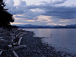
Looking up Sutil Channel from Quadra Island
Sutil Channel is located in British Columbia
Sutil Channel

Sutil Channel

Location of Sutil Channel among the Discovery Islands
LocationDiscovery Islands, British Columbia
Coordinates50°8′N 125°4′W / 50.133°N 125.067°W / 50.133; -125.067
TypeStrait
Ocean/sea sourcesSalish Sea
IslandsCoulter Island, Hill Island, Marina Island, Penn Islands
References[1]

Sutil Channel (French: Canal Sutil) is a broad strait located in the Discovery IslandsofBritish Columbia, Canada.

Etymology[edit]

Sutil Channel was named around 1864 by Captain George Henry Richards in honor of the ship Sutil used by Dionisio Alcalá Galiano in exploring the region in 1792.[2] A group of small islands in Sutil Channel called the Subtle Islands are named for Galiano's ship as well, translated to English.[3]

Geography[edit]

Extent[edit]

Sutil Channel is located between Cortes Island to the east, and Quadra Island and Read Island to the west. It connects Calm Channel to the north with the Strait of Georgia to the south. Hoskyn Channel branches off toward the northwest from the Sutil Channel between Read Island and Quadra Island. Van Densp Inlet branches off from the northern end of the channel to incise Cortes Island from the northwest.

The southern boundary of Sutil Channel, where it joins the Strait of Georgia, is defined as a line between Francisco Point, at the southeast end of Quadra Island, to Sutil Point, the southern end of Cortes Island. Sometimes Cape Mudge instead of Francisco Point is mentioned as the southern end of Quadra Island. The boundary between Sutil Channel and Hoskyn Channel is a line between Rebecca Spit on Quadra Island and Read Point on Read Island. Wide in the south, Sutil Channel narrows in the north, and merges with Calm Channel at the northernmost point of Cortes Island in the vicinity of the Rendezvous Islands. Settlements on the shore of Sutil Channel include Whaletown on Cortes Island.[4] Desolation Sound, which strictly defined does not directly connect to Sutil Channel, is sometimes used loosely as all the waters north of Cape Mudge and Sarah Point, including Sutil Channel and Discovery Passage.[5]

Major features[edit]

The major bays of Sutil Channel include Burwood Bay, Carrington Bay, Coulter Bay, Evans Bay, George Harbour, and Manson Bay. The major islands of Sutil Channel include Coulter Island, Hill Island, Marina Island, and the Penn Islands.

Hydrology[edit]

The Penn Islands of Sutil Channel delineate part of the northern limit of the Salish Sea.[6]

See also[edit]

References[edit]

  1. ^ "Homfray Channel". apps.gov.bc.ca. Retrieved 2020-09-29.
  • ^ "Sutil Channel". BC Geographical Names.
  • ^ "Subtle Islands". BC Geographical Names.
  • ^ Geography from Base Map Online Store Archived 2008-05-09 at the Wayback Machine, TRIM 1:20,000 Digital Base Maps, British Columbia Integrated Land Management Bureau, Base Mapping and Geomatic Services; and Hale, Robert (2007). Waggoner Cruising Guide 2007. Weatherly Press. ISBN 978-0-935727-26-5.
  • ^ Hale, Robert (2007). Waggoner Cruising Guide 2007. Weatherly Press. p. 208. ISBN 978-0-935727-26-5.
  • ^ Environmental History and Features of Puget Sound Archived 2009-05-13 at the Wayback Machine, NOAA-NWFSC

  • t
  • e

  • Retrieved from "https://en.wikipedia.org/w/index.php?title=Sutil_Channel&oldid=1202094820"

    Categories: 
    Central Coast of British Columbia
    Landforms of the Discovery Islands
    Channels of British Columbia
    Salish Sea
    Central Coast of British Columbia geography stubs
    Hidden categories: 
    Pages using gadget WikiMiniAtlas
    Webarchive template wayback links
    Articles with short description
    Short description is different from Wikidata
    Pages using infobox body of water with auto short description
    Articles containing French-language text
    Coordinates on Wikidata
    Articles using infobox body of water without alt
    Articles using infobox body of water without pushpin map alt
    Articles using infobox body of water without alt bathymetry
    All stub articles


    This page was last edited on 2 February 2024, at 01:18 (UTC).

    Text is available under the Creative Commons Attribution-ShareAlike License 4.0; additional terms may apply. By using this site, you agree to the Terms of Use and Privacy Policy. Wikipedia® is a registered trademark of the Wikimedia Foundation, Inc., a non-profit organization.


    Privacy policy

    About Wikipedia

    Disclaimers

    Contact Wikipedia

    Code of Conduct

    Developers

    Statistics

    Cookie statement

    Mobile view


    Wikimedia Foundation
    Powered by MediaWiki