Jump to content


Main menu


Navigation  


Main page
Contents
Current events
Random article
About Wikipedia
Contact us
Donate


Contribute  


Help
Learn to edit
Community portal
Recent changes
Upload file


Search  


Create account

Log in


Create account
 Log in


Pages for logged out editors learn more  


Contributions
Talk


Contents


(Top)


1 Etymology  


2 History and archaeology  


2.1  Early habitation periods  


2.2  Byzantine and Early Muslim period: Christian village  


2.3  Mamluk period  


2.4  Ottoman period  


2.5  British Mandate  


2.6  State of Israel  


3 See also  


4 References  


5 Bibliography  


6 External links  


Tamra, Jezreel Valley


Čeština
עברית
Norsk nynorsk
Polski
اردو
 

Edit links


Article
Talk


Read
Edit
View history


Tools


Actions  


Read
Edit
View history


General  


What links here
Related changes
Upload file
Special pages
Permanent link
Page information
Cite this page
Get shortened URL
Download QR code
Wikidata item


Print/export  


Download as PDF
Printable version


In other projects  


Wikimedia Commons


Appearance


Coordinates: 32°385N 35°248E / 32.63472°N 35.40222°E / 32.63472; 35.40222
 

From Wikipedia, the free encyclopedia
 

(Redirected from Tamra, Galilee)

Tamra
Tamra
Tamra
Tamra is located in Jezreel Valley region of Israel
Tamra

Tamra

Coordinates: 32°38′5N 35°24′8E / 32.63472°N 35.40222°E / 32.63472; 35.40222
Grid position188/226 PAL
CountryIsrael
DistrictNorthern
CouncilGilboa
Population
 (2022)[1]
1,677

Tamra (Arabic: طمرة; Hebrew: טַמְרָהorתַמְרָה‎) is an Arab village in north-eastern Israel. Located in the Jezreel Valley, it falls under the jurisdiction of Gilboa Regional Council. In 2022 it had a population of 1,677.[1]

Etymology[edit]

The name Tamra is derived from the Arabic to make a pit for storing corn & c.[2]

History and archaeology[edit]

Early habitation periods[edit]

Remains from the Iron Age I era have been excavated.[3] Remains from the Iron Age II, the Late PersianEarly Hellenistic, Roman[4][5][6] and Byzantine periods have been found here.[5][6][7]

Byzantine and Early Muslim period: Christian village[edit]

There was village at the site during the Byzantine period; tombs and remnants of two churches have been found.[8] In the Byzantine and Early Muslim periods, there was an agricultural settlement here.[3][9]

Remains from the Early Islamic (Umayyad & Abbasid) period have bern unearthed here,[5][6][7] including Umayyad glass vessels and Abbasid pottery and a lamp.[10] Remains dating to the Umayyad period (seventh–eighth centuries CE) have been excavated,[4] together with housing remains dating to the Early Abbasid period (late eighth and early ninth centuries CE).[9]

Abasilica-style church was built here during the Umayyad period, with a dedication from 725 CE found in the middle. Mosaics belonging to the church have been excavated. The church was probably damaged in the 749 Galilee earthquake, after which its columns were replaced with square pilasters.[3] The archaeological evidence indicates that a thriving Christian community existed here in the Umayyad and the Abbasid periods.[3] Two complex winepress that were operated in the Umayyad and Abbasid periods have also been found, indicating widespread wine production during these periods.[9][11]

Mamluk period[edit]

Mamluk-period remains have also been found.[6]

Ottoman period[edit]

During the Ottoman era, a map by Pierre Jacotin from Napoleon's invasion of 1799 may have noted the place, as a village.[12]

In 1870–1871 an Ottoman census listed the village in the nahiya (sub-district) of Shafa al-Shamali.[13] In 1875, the French explorer Victor Guérin visited Tamra and found it to be a village of about 120 inhabitants, living in adobe houses, or houses built of volcanic materials.[14] He further noted:

This village has taken the place of an ancient town which formerly rose in an amphitheatre around an abundant spring, whose waters are received in a regular basin formerly vaulted. Everywhere considerable piles of stones, for the most part basaltic; the remains of overthrown houses strew the slopes of the hill. In the midst of these confused ruins I remarked, near the spring, the vestiges of a small church lying east and west and divided into three naves. It was ornamented with columns, of which several trunks yet remain. In the higher part of the city are still distinguished the remains of a second church, almost entirely destroyed, which was paved with mosaic, as is proven by the little cubes lying about on the ground.[15]

In 1882, the PEF's Survey of Western Palestine (SWP) described Tumrah as "a village of middling size, perhaps 50 or 70 houses, situated on high ground, and surrounded by plough-land." They also noted that there were ruins on the south side of the village.[16]

British Mandate[edit]

In the 1922 census of Palestine conducted by the British Mandate authorities, Thamra showed a population of 104, all Muslims,[17] increasing in the 1931 census to 193, still all Muslims, in a total of 34 houses.[18]

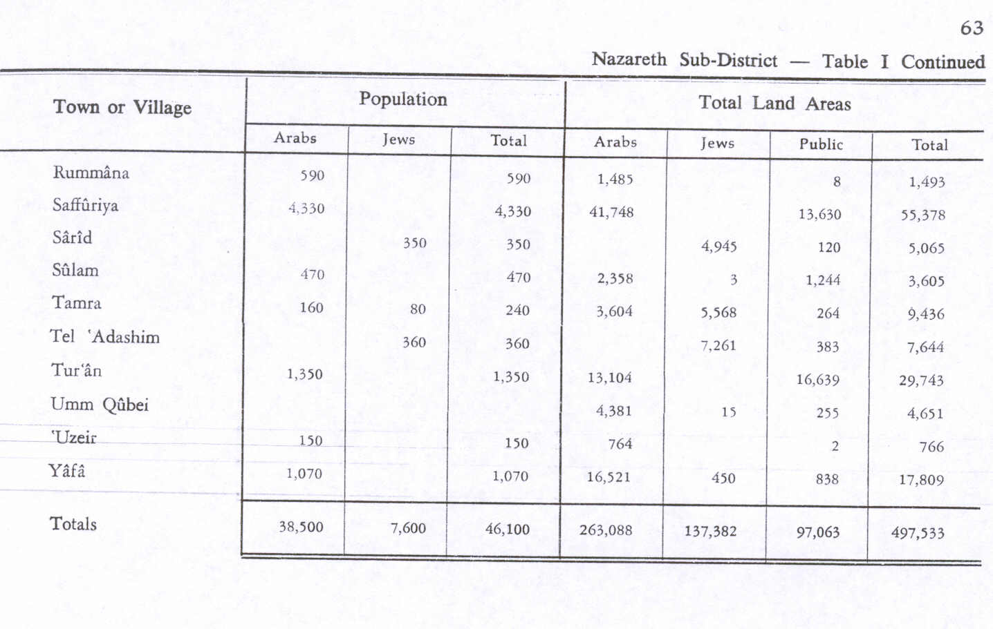
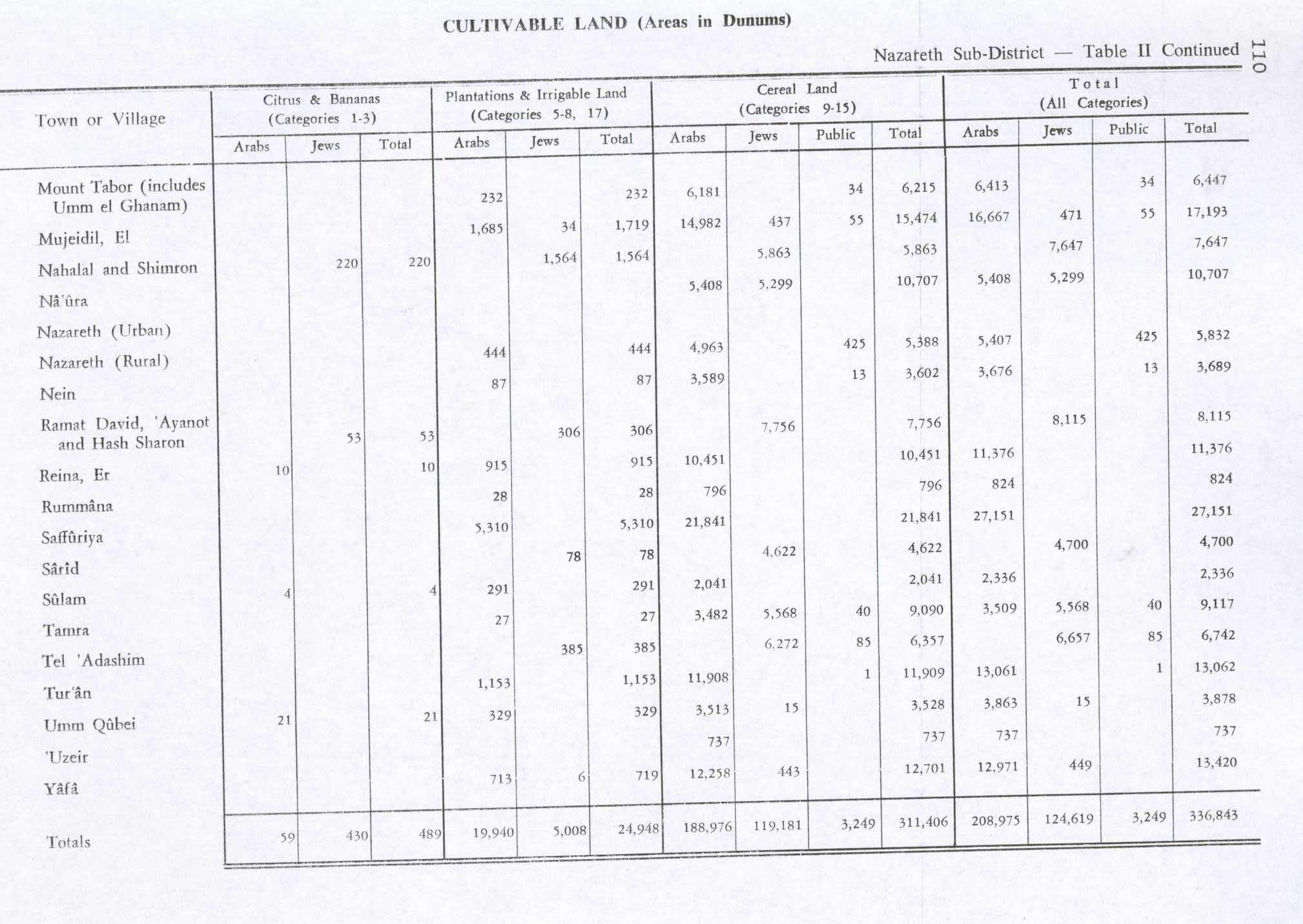
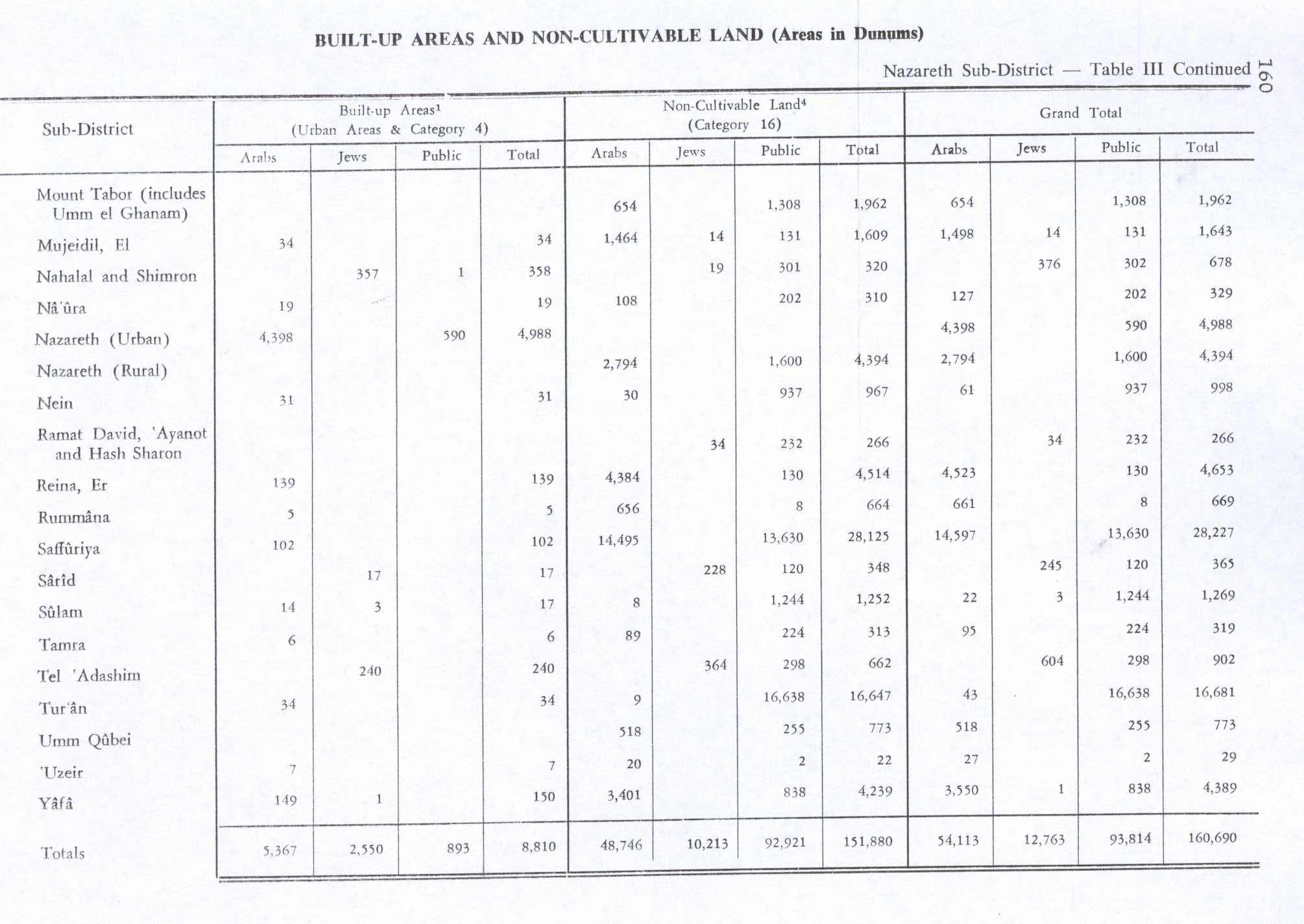
In the 1945 statistics Tamra had 240 inhabitants, 160 Arabs and 80 Jews,[19] with a total of 9,436 dunams of land, according to an official land and population survey.[20] Of this, 27 dunams were plantations and irrigable land, 9,090 dunams were used for cereals,[21] while 6 dunams were built-up land.[22]

State of Israel[edit]

Since 1948 Tamra has been under Israeli rule.

See also[edit]

References[edit]

  1. ^ a b "Regional Statistics". Israel Central Bureau of Statistics. Retrieved 21 March 2024.
  • ^ Palmer, 1881, p. 170, see p. 117
  • ^ a b c d Tepper, 2013, Tamra, Preliminary Report
  • ^ a b Mokary, 2010, Tamra
  • ^ a b c Porat, 2005, Tamra
  • ^ a b c d Tepper, 2007, Tamra Final Report
  • ^ a b Abu Fana, 2009, Tamra Final Report
  • ^ Tsafrir, Di Segni and Green, 1994, p. 239
  • ^ a b c Tepper, 2011, Tamra
  • ^ Porat, 2007, Tamra
  • ^ Tepper, 2013, Tamra, in the Valley
  • ^ Karmon, 1960, p. 167 Archived 2019-12-22 at the Wayback Machine.
  • ^ Grossman, David (2004). Arab Demography and Early Jewish Settlement in Palestine. Jerusalem: Magnes Press. p. 256.
  • ^ Guérin, 1880, p. 124
  • ^ Guérin, 1880, pp. 124-125, as translated by Conder and Kitchener, 1882, SWP II, p. 130
  • ^ Conder and Kitchener, 1882, SWP II, pp. 87- 88
  • ^ Barron, 1923, Table XI, Sub-district of Nazareth, p. 38
  • ^ Mills, 1932, p. 76
  • ^ Department of Statistics, 1945, p. 8
  • ^ Government of Palestine, Department of Statistics. Village Statistics, April, 1945. Quoted in Hadawi, 1970, p. 63
  • ^ Government of Palestine, Department of Statistics. Village Statistics, April, 1945. Quoted in Hadawi, 1970, p. 110
  • ^ Government of Palestine, Department of Statistics. Village Statistics, April, 1945. Quoted in Hadawi, 1970, p. 160
  • Bibliography[edit]

    • Abu Fana, Mohammed (2009-12-30). "Tamra Final Report" (121). Hadashot Arkheologiyot – Excavations and Surveys in Israel. {{cite journal}}: Cite journal requires |journal= (help)
  • Alexandre, Yardenna (2009-08-23). "Tamra Final Report" (121). Hadashot Arkheologiyot – Excavations and Surveys in Israel. {{cite journal}}: Cite journal requires |journal= (help)
  • Barron, J.B., ed. (1923). Palestine: Report and General Abstracts of the Census of 1922. Government of Palestine.
  • Conder, C.R.; Kitchener, H.H. (1882). The Survey of Western Palestine: Memoirs of the Topography, Orography, Hydrography, and Archaeology. Vol. 2. London: Committee of the Palestine Exploration Fund.
  • Dauphin, C. (1998). La Palestine byzantine, Peuplement et Populations. BAR International Series 726 (in French). Vol. III : Catalogue. Oxford: Archeopress. ISBN 0-86054-905-4. (p. 734)
  • Department of Statistics (1945). Village Statistics, April, 1945. Government of Palestine.
  • Guérin, V. (1880). Description Géographique Historique et Archéologique de la Palestine (in French). Vol. 3: Galilee, pt. 1. Paris: L'Imprimerie Nationale.
  • Hadawi, S. (1970). Village Statistics of 1945: A Classification of Land and Area ownership in Palestine. Palestine Liberation Organization Research Center.
  • Karmon, Y. (1960). "An Analysis of Jacotin's Map of Palestine" (PDF). Israel Exploration Journal. 10 (3, 4): 155–173, 244–253. Archived from the original (PDF) on 2019-12-22. Retrieved 2015-04-23.
  • Mills, E., ed. (1932). Census of Palestine 1931. Population of Villages, Towns and Administrative Areas. Jerusalem: Government of Palestine.
  • Mokary, Abdalla (2010-12-30). "Tamra" (122). Hadashot Arkheologiyot – Excavations and Surveys in Israel. {{cite journal}}: Cite journal requires |journal= (help)
  • Palmer, E.H. (1881). The Survey of Western Palestine: Arabic and English Name Lists Collected During the Survey by Lieutenants Conder and Kitchener, R. E. Transliterated and Explained by E.H. Palmer. Committee of the Palestine Exploration Fund.
  • Porat, Leea (2005-04-13). "Tamra" (117). Hadashot Arkheologiyot – Excavations and Surveys in Israel. {{cite journal}}: Cite journal requires |journal= (help)
  • Porat, Leea (2007-12-16). "Tamra" (119). Hadashot Arkheologiyot – Excavations and Surveys in Israel. {{cite journal}}: Cite journal requires |journal= (help)
  • Tepper, Y. (2007-08-16). "Tamra Final Report" (119). Hadashot Arkheologiyot – Excavations and Surveys in Israel. {{cite journal}}: Cite journal requires |journal= (help)
  • Tepper, Y. (2011-09-11). "Tamra Preliminary Report" (123). Hadashot Arkheologiyot – Excavations and Surveys in Israel. {{cite journal}}: Cite journal requires |journal= (help)
  • Tepper, Y. (2013-12-31). "Tamra Preliminary Report" (125). Hadashot Arkheologiyot – Excavations and Surveys in Israel. {{cite journal}}: Cite journal requires |journal= (help)
  • Tepper, Y. (2013-12-08). "Tamra, in the Valley" (125). Hadashot Arkheologiyot – Excavations and Surveys in Israel. {{cite journal}}: Cite journal requires |journal= (help)
  • Tsafrir, Y.; Leah Di Segni; Judith Green (1994). (TIR): Tabula Imperii Romani: Judaea, Palaestina. Jerusalem: Israel Academy of Sciences and Humanities. ISBN 965-208-107-8.
  • External links[edit]


    Retrieved from "https://en.wikipedia.org/w/index.php?title=Tamra,_Jezreel_Valley&oldid=1221063405"

    Categories: 
    Gilboa Regional Council
    Arab villages in Israel
    Populated places in Northern District (Israel)
    Jezreel Valley
    Hidden categories: 
    Pages using gadget WikiMiniAtlas
    Webarchive template wayback links
    Articles with short description
    Short description is different from Wikidata
    Coordinates on Wikidata
    Articles containing Arabic-language text
    Articles containing Hebrew-language text
    CS1 errors: missing periodical
    CS1: long volume value
    CS1 French-language sources (fr)


    This page was last edited on 27 April 2024, at 16:55 (UTC).

    Text is available under the Creative Commons Attribution-ShareAlike License 4.0; additional terms may apply. By using this site, you agree to the Terms of Use and Privacy Policy. Wikipedia® is a registered trademark of the Wikimedia Foundation, Inc., a non-profit organization.


    Privacy policy

    About Wikipedia

    Disclaimers

    Contact Wikipedia

    Code of Conduct

    Developers

    Statistics

    Cookie statement

    Mobile view


    Wikimedia Foundation
    Powered by MediaWiki