Jump to content


Main menu


Navigation  


Main page
Contents
Current events
Random article
About Wikipedia
Contact us
Donate


Contribute  


Help
Learn to edit
Community portal
Recent changes
Upload file


Search  


Create account

Log in


Create account
 Log in


Pages for logged out editors learn more  


Contributions
Talk


Contents


(Top)


1 History  


2 Geography  


3 Administration  


3.1  Central administration  


3.2  Local administration  


4 Local festival  


5 References  


6 External links  


Tha Pla district


 / Bân-lâm-gú
Cebuano
Deutsch

িি ি
Italiano
Română

Tiếng Vit
 

Edit links


Article
Talk


Read
Edit
View history


Tools


Actions  


Read
Edit
View history


General  


What links here
Related changes
Upload file
Special pages
Permanent link
Page information
Cite this page
Get shortened URL
Download QR code
Wikidata item


Print/export  


Download as PDF
Printable version


In other projects  


Wikimedia Commons


Appearance


Coordinates: 17°4735N 100°2238E / 17.79306°N 100.37722°E / 17.79306; 100.37722
 

From Wikipedia, the free encyclopedia


Tha Pla
ท่าปลา
The Nan River, Tha Pla district
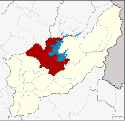
District location in Uttaradit province
Coordinates: 17°47′35N 100°22′38E / 17.79306°N 100.37722°E / 17.79306; 100.37722
Country Thailand
ProvinceUttaradit
SeatTha Pla
Tambon7
Muban76
Area
 • Total1,681.445 km2 (649.210 sq mi)
Population
 (2014)
 • Total44,025
 • Density29.1/km2 (75/sq mi)
Time zoneUTC+07:00 (ICT)
Postal code53150
Geocode5303

Tha Pla (Thai: ท่าปลา, pronounced [tʰâː plāː]) is a district (amphoe) of Uttaradit province, in Northern Thailand.

History[edit]

Tha Pla was originally part of Nan province until it was reassigned in 1923 to Uttaradit Province.[1]

Geography[edit]

Neighbouring districts are (from the east in a clockwise order): Nam Pat, Thong Saen Khan and Mueang Uttaradit of Uttaradit Province, Den Chai, Sung Men and Mueang PhraeofPhrae province, and Na MuenofNan province.

The main river of the district is the Nan River, with the Sirikit Dam creating a 250 km2 artificial lake. The Pat River joins the Nan below the dam.

Administration[edit]

Central administration[edit]

Tha Pla is divided into seven sub-districts (tambon), which are further subdivided into 76 administrative villages (Muban).

No. Name Thai Villages Pop.[2]
01. Tha Pla ท่าปลา 12 8,574
02. Hat La หาดล้า 09 4,696
03. Pha Lueat ผาเลือด 13 6,748
04. Charim จริม 13 8,642
05. Nam Man น้ำหมัน 12 7,172
07. Nang Phaya นางพญา 06 2,634
08. Ruam Chit ร่วมจิต 11 5,559

Number 6 belonged to the subdistrict Tha Faek reassigned to Nam Pat District in 2015.

Local administration[edit]

There are three sub-district municipalities (thesaban tambon) in the district:

There are six sub-district administrative organizations (SAO) in the district:

Local festival[edit]

Phi Talok (Thai: ผีตลก; lit: funny ghost) - a post Buddhist Lent festival (around October) of Tha Pla, this ghost mask festival has dual names. While Tha Pla people call this ‘Phi Talok,’ those in Hat La or Tha Faek know it as ‘Phi Hua Khon’ (Khon mask ghost). But whatever the name, this event is all about the belief in heaven and hell. This festival is similar to Phi Ta KhonofDan Sai district, Loei province and has been organized continuously for over 200 years.[3]

References[edit]

  1. ^ ประกาศโอนอำเภอท่าปลาจากจังหวัดน่านมาขึ้นจังหวัดอุตรดิตถ์ (PDF). Royal Gazette (in Thai). 39 (ก): 55. 1922-06-04. Archived from the original (PDF) on June 1, 2012.
  • ^ "Population statistics 2014" (in Thai). Department of Provincial Administration. Retrieved 2015-03-16.
  • ^ Phuengsuk, Prasit (2019-10-04). "ประเพณีแห่ผีตลกหนึ่งเดียวในโลก" [Phi Talok parade festival, one-of-a-kind in the world]. Thai Rath (in Thai). Retrieved 2019-10-09.
  • External links[edit]


  • t
  • e

  • Retrieved from "https://en.wikipedia.org/w/index.php?title=Tha_Pla_district&oldid=1151603553"

    Categories: 
    Districts of Uttaradit province
    Uttaradit province geography stubs
    Hidden categories: 
    Pages using gadget WikiMiniAtlas
    CS1 uses Thai-language script (th)
    CS1 Thai-language sources (th)
    Articles with short description
    Short description matches Wikidata
    Short description is different from Wikidata
    Coordinates on Wikidata
    Articles containing Thai-language text
    Pages with Thai IPA
    Articles with Thai-language sources (th)
    Articles with VIAF identifiers
    Articles with J9U identifiers
    Articles with LCCN identifiers
    All stub articles


    This page was last edited on 25 April 2023, at 02:02 (UTC).

    Text is available under the Creative Commons Attribution-ShareAlike License 4.0; additional terms may apply. By using this site, you agree to the Terms of Use and Privacy Policy. Wikipedia® is a registered trademark of the Wikimedia Foundation, Inc., a non-profit organization.


    Privacy policy

    About Wikipedia

    Disclaimers

    Contact Wikipedia

    Code of Conduct

    Developers

    Statistics

    Cookie statement

    Mobile view


    Wikimedia Foundation
    Powered by MediaWiki