Jump to content


Main menu


Navigation  


Main page
Contents
Current events
Random article
About Wikipedia
Contact us
Donate


Contribute  


Help
Learn to edit
Community portal
Recent changes
Upload file


Search  


Create account

Log in


Create account
 Log in


Pages for logged out editors learn more  


Contributions
Talk


Contents


(Top)


1 History  


2 Name  


3 See also  


4 References  


5 External links  


Te Urewera National Park


Basa Bali
Deutsch
Español
Français
עברית

Македонски
Nederlands

Norsk nynorsk
پنجابی
Polski
Português
Русский
Svenska

Türkçe


Edit links


Article
Talk


Read
Edit
View history


Tools


Actions  


Read
Edit
View history


General  


What links here
Related changes
Upload file
Special pages
Permanent link
Page information
Cite this page
Get shortened URL
Download QR code
Wikidata item


Print/export  


Download as PDF
Printable version


In other projects  


Wikimedia Commons


Appearance


Coordinates: 38°450S 177°90E / 38.75000°S 177.15000°E / -38.75000; 177.15000
 

From Wikipedia, the free encyclopedia
 

(Redirected from Urewera National Park)

Te Urewera National Park

IUCN category II (national park)

Map showing the location of Te Urewera National Park

Location on map of New Zealand

LocationHawke's Bay
Nearest cityGisborne, New Zealand
Coordinates38°45′0″S 177°9′0″E / 38.75000°S 177.15000°E / -38.75000; 177.15000
Area2,127 km2 (821 sq mi)
Established1954
Disestablished2014
Governing bodyDepartment of Conservation
WebsiteDOC page

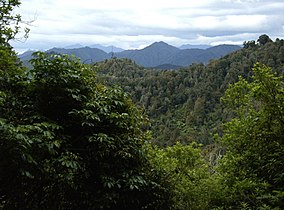
Te Urewera National Park was a national park near the east coast of New Zealand's North Island, established as such in 1954 and disestablished in 2014, when it was replaced by a new legal entity and protected area named Te Urewera.[1] The park covered an area of approximately 2,127 km2 and was located in the north of the Hawke's Bay region of the North Island. It was the largest of four national parks in the North Island and the most isolated rainforest in the region.[2]

History[edit]

Owing to its geographical isolation, the region was one of the last to be claimed by the British during colonisation in the 19th century.[3]

On 28 July 1954, the catchment areas of Lake Waikaremoana and Lake Waikareiti and other Crown reserves were gazetted as a national park, and by 1957 proposals were well under way to add the rest of the Crown land in Te Urewera north of Ruatāhuna. This proposal was formalised in November 1957, when an additional 1,350 km2 were added. Further additions were made in 1962, 1975, and 1979, with smaller acquisitions of land and boundary alterations in the intervening period. The lake bed and Māori enclaves were not included in the gazetting of the park. The Crown had leased the lake bed, which was managed by the Department of Conservation.

In March 2013, the Tūhoe people signed a deed of settlement, settling the tribe's claims under the Waitangi Tribunal. Under the deal, the Tūhoe were to receive NZ$170 million and also be given more control over Te Urewera.[3] It ceased to be a national park under the Te Urewera Act 2014, becoming Te Urewera,[1][4] the first natural resource in the world to be awarded the same legal rights as a person.[5][6]

Name[edit]

Te Urewera is the traditional home of the Tūhoe people. The name means “burnt penis” in the Māori language and reflects a local legend.[7]

See also[edit]

References[edit]

  1. ^ a b Ruru, Jacinta (October 2014). "Tūhoe-Crown settlement – Te Urewera Act 2014". Māori Law Review: 16–21. Retrieved 13 December 2015.
  • ^ "Te Urewera: New Zealand's 'living' rainforest". No. BBC Travel. BBC. 30 September 2021.
  • ^ a b "Govt and Tuhoe sign $170m settlement". Newshub. 22 March 2013. Archived from the original on 24 March 2016.
  • ^ Cheng, Derek (25 July 2014). "Tuhoe takes lead in homeland's future". The New Zealand Herald. Retrieved 25 July 2014.
  • ^ Gibson, Jacqui (9 June 2020). "The Māori tribe protecting New Zealand's sacred rainforest". BBC Travel. Retrieved 29 September 2021.
  • ^ BBC's The Travel Show (29 September 2021). "Te Urewera: New Zealand's 'living' rainforest". BBC Travel. Retrieved 29 September 2021.
  • ^ Lind, Clive (31 January 2009). "Deep into the land of the mist". Stuff. Archived from the original on 15 March 2018.
  • External links[edit]


    Retrieved from "https://en.wikipedia.org/w/index.php?title=Te_Urewera_National_Park&oldid=1216295209"

    Categories: 
    IUCN Category II
    Protected areas established in 1954
    Protected areas disestablished in 2014
    Nature reserves in New Zealand
    Wildlife sanctuaries of New Zealand
    Protected areas of the Hawke's Bay Region
    Former national parks
    Whakatane District
    Ōpōtiki District
    Gisborne District
    Wairoa District
    National parks of New Zealand
    Hidden categories: 
    Pages using gadget WikiMiniAtlas
    Articles with short description
    Short description is different from Wikidata
    Use dmy dates from April 2022
    Use New Zealand English from February 2024
    All Wikipedia articles written in New Zealand English
    Coordinates on Wikidata
    Articles with VIAF identifiers
    Articles with WorldCat Entities identifiers
    Articles with GND identifiers
    Articles with LCCN identifiers


    This page was last edited on 30 March 2024, at 07:37 (UTC).

    Text is available under the Creative Commons Attribution-ShareAlike License 4.0; additional terms may apply. By using this site, you agree to the Terms of Use and Privacy Policy. Wikipedia® is a registered trademark of the Wikimedia Foundation, Inc., a non-profit organization.


    Privacy policy

    About Wikipedia

    Disclaimers

    Contact Wikipedia

    Code of Conduct

    Developers

    Statistics

    Cookie statement

    Mobile view


    Wikimedia Foundation
    Powered by MediaWiki