Jump to content


Main menu


Navigation  


Main page
Contents
Current events
Random article
About Wikipedia
Contact us
Donate


Contribute  


Help
Learn to edit
Community portal
Recent changes
Upload file


Search  


Create account

Log in


Create account
 Log in


Pages for logged out editors learn more  


Contributions
Talk


Contents


(Top)


1 History  


2 Demography  


2.1  Population  


3 Geography  


3.1  Districts  


3.2  Parks and gardens  


3.3  Climate  


4 Sport  


5 Twin towns  sister cities  


6 Gallery  


7 References  


8 External links  


Utena


Afrikaans
العربية
Azərbaycanca
Беларуская
Беларуская (тарашкевіца)
Български
Català
Cebuano
Čeština
Dansk
Deutsch
Eesti
Ελληνικά
Эрзянь
Español
Esperanto
فارسی
Français

Հայերեն
Hornjoserbsce
Bahasa Indonesia
Ирон
Italiano
עברית

Kernowek
Kiswahili
Latviešu
Lietuvių
Македонски
Māori
مصرى
Мокшень
Nederlands

Nordfriisk
Norsk bokmål
Norsk nynorsk
پنجابی
پښتو
Piemontèis
Polski
Português
Română
Русский
Simple English
Српски / srpski
Srpskohrvatski / српскохрватски
Suomi
Svenska
Türkçe
Українська
اردو
Vepsän kel
Tiếng Vit
Volapük

ייִדיש

Zazaki
Žemaitėška


Edit links


Article
Talk


Read
Edit
View history


Tools


Actions  


Read
Edit
View history


General  


What links here
Related changes
Upload file
Special pages
Permanent link
Page information
Cite this page
Get shortened URL
Download QR code
Wikidata item


Print/export  


Download as PDF
Printable version


In other projects  


Wikimedia Commons
Wikivoyage


Appearance


Coordinates: 55°30N 25°36E / 55.500°N 25.600°E / 55.500; 25.600
 

From Wikipedia, the free encyclopedia


Utena
City
Coat of arms of Utena
Utena is located in Lithuania
Utena

Utena

Location of Utena in Lithuania

Utena is located in Baltic states
Utena

Utena

Location of Utena within the Baltics

Utena is located in Europe
Utena

Utena

Location of Utena in Europe

Coordinates: 55°30′N 25°36′E / 55.500°N 25.600°E / 55.500; 25.600
Country Lithuania
Ethnographic regionAukštaitija
County Utena County
MunicipalityUtena district municipality
EldershipUtena town eldership
Capital ofUtena district municipality
Utena town eldership
Utena rural eldership
First mentioned1261
Granted city rights1599
Government
 • MayorMarijus Kaukėnas
Area
 • City15.3 km2 (5.9 sq mi)
Elevation
113 m (371 ft)
Population
 (2020)
 • City25,397
 • Density1,700/km2 (4,300/sq mi)
 • Metro
48,378
Time zoneUTC+2 (EET)
 • Summer (DST)UTC+3 (EEST)
Postal code
28xxx
Area code(+370) 389
Websiteutena.lt
Map

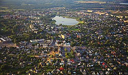
Utena (pronunciation, German: Utenen) is a city in north-east Lithuania. It is the administrative centerofUtena district and Utena County. Utena is one of the oldest settlements of Lithuania. The name of the city is most probably derived from a hydronym.[1] The name of the settlement has been known since 1261.[1][2][3][4]

Utena is an industrial city. It is known for its clothing, food and beverage factories. In recent years, however, streets, public squares and large areas of the parks in the city were reconstructed and Utena is now more attractive for recreation and tourism.

The anniversary of Utena City had been held each year on the last weekend of September. Since 2013 the anniversary has been held on the first weekend of September to take advantage of better weather conditions.

History

[edit]
Utena was the location of one of many Roman Catholic churches where the priests had to know the Lithuanian language according to the Grand Duke of Lithuania Alexander Jagiellon in 1501
Utena, circa 1930
Museum of local history

Utena was first mentioned in historical documents dating back to 1261. The settlement was a major center of Nalšia. It was part of the Grand Duchy of Lithuania until 1795, when it fell under the Russian Empire rule. From 1802 it belonged to the Vilna Governorate until 1843 when it became a part of the Kovno Governorate. The town grew rapidly after the St.Petersburg-Warsaw road was constructed between 1830 and 1835. In 1899 a narrow gauge railway line, connecting Panevėžys-Utena-Švenčionys, was constructed. At the end of the 19th century two big fires devastated the town.

Germany occupied Utena from 1915 to 1918, until the Soviet Bolsheviks took over. Following the defeat of Soviets, in June 1919, Utena became a district center in independent Lithuania.[5]

Utena, known as the shtetl Utyan in Yiddish, historically had a Jewish population. In 1941, approximately 2,000 Jews were rounded up in the town, which was then under the Nazi occupation, and shot in the Rašė Forest about 2 km (1.2 mi) to the north.[6]
Demography

[edit]
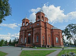
Church of the Ascension of Christ, built in 1898

Population

[edit]

According to the 2021 census, the city population was 25,343 people, of which:[7]

Historical population
YearPop.±% p.a.
1939 6,276—    
1959 7,066+0.59%
1979 23,461+6.18%
1989 34,430+3.91%
1999 36,100+0.47%
2005 33,086−1.44%
YearPop.±% p.a.
2006 32,881−0.62%
2007 32,789−0.28%
2008 32,572−0.66%
2009 32,476−0.29%
2010 31,940−1.65%
Source: [8][9]

Geography

[edit]

Utena is located in northeastern Lithuania. The city covers 15.1 km2 and is the eighth-largest city by area in Lithuania. Four rivers cross the city territory: Vyžuona, Krašuona, Vieša and Utenėlė. There are also two lakes in Utena, Dauniškis and Vyžuonaitis.

Districts

[edit]

The city is divided into 10 districts:

Parks and gardens

[edit]

Climate

[edit]

Under the Köppen climate classification, Utena has a humid continental climate (Dfb). The lowest temperature ever recorded in Lithuania occurred in Utena: −42.9 °C (−45.2 °F) on 1 February 1956.[10]

Climate data for Utena (1961−1990 normals, extremes 1925−1990)
Month Jan Feb Mar Apr May Jun Jul Aug Sep Oct Nov Dec Year
Record high °C (°F) 7.7
(45.9)
13.3
(55.9)
19.5
(67.1)
26.8
(80.2)
30.8
(87.4)
31.7
(89.1)
34.4
(93.9)
32.0
(89.6)
28.4
(83.1)
23.4
(74.1)
15.9
(60.6)
10.5
(50.9)
34.4
(93.9)
Mean daily maximum °C (°F) −3.2
(26.2)
−2.0
(28.4)
2.9
(37.2)
10.5
(50.9)
18.0
(64.4)
21.2
(70.2)
22.3
(72.1)
21.5
(70.7)
16.3
(61.3)
10.3
(50.5)
3.7
(38.7)
−0.9
(30.4)
10.0
(50.1)
Daily mean °C (°F) −6.0
(21.2)
−5.2
(22.6)
−1.2
(29.8)
5.5
(41.9)
12.2
(54.0)
15.6
(60.1)
16.8
(62.2)
15.9
(60.6)
11.4
(52.5)
6.6
(43.9)
1.4
(34.5)
−3.2
(26.2)
5.8
(42.5)
Mean daily minimum °C (°F) −9.1
(15.6)
−8.7
(16.3)
−4.8
(23.4)
1.2
(34.2)
6.5
(43.7)
9.9
(49.8)
11.5
(52.7)
10.8
(51.4)
7.3
(45.1)
3.3
(37.9)
−0.9
(30.4)
−6.1
(21.0)
1.7
(35.1)
Record low °C (°F) −38.9
(−38.0)
−42.9
(−45.2)
−33.7
(−28.7)
−17.6
(0.3)
−4.6
(23.7)
−1.5
(29.3)
3.7
(38.7)
−0.1
(31.8)
−5.2
(22.6)
−13.2
(8.2)
−20.0
(−4.0)
−31.3
(−24.3)
−42.9
(−45.2)
Average precipitation mm (inches) 39
(1.5)
31
(1.2)
37
(1.5)
47
(1.9)
53
(2.1)
69
(2.7)
73
(2.9)
75
(3.0)
66
(2.6)
50
(2.0)
57
(2.2)
53
(2.1)
650
(25.7)
Mean monthly sunshine hours 34.9 63.6 140.2 206.8 259.8 263.1 251.1 231.8 160.9 92.5 25.6 20.4 1,750.7
Source 1: NOAA[11]
Source 2: infoclimat.fr (sunshine 1991–2020)[12][better source needed]

Sport

[edit]
Stadium of the FK Utenis Utena

FK Utenis Utena plays in A Lyga and BC Juventus plays in LKL.

Hometown of Jonas Valančiūnas of the New Orleans Pelicans.

Aidenas Malašinskas is the best handball player in Lithuania (2019, 2021).

Twin towns – sister cities

[edit]

Utena is twinned with:[13]

  • Ukraine Kovel, Ukraine
  • Sweden Lidköping, Sweden
  • Italy Pontinia, Italy
  • Latvia Preiļi, Latvia
  • Latvia Rēzekne, Latvia
  • Czech Republic Třeboň, Czech Republic
  • State of Palestine Beit Sahour, Palestine
  • [edit]

    References

    [edit]
    1. ^ a b "Utenos Enciklopedija (English summary)". Utenos Enciklopedija. Utenos A. ir M. Miškinių viešoji biblioteka. 2002. Retrieved 30 June 2008.
  • ^ "Utena". Visuotinė lietuvių enciklopedija (in Lithuanian). Retrieved 23 December 2023.
  • ^ "Utena County - Geography and history". circabc.europa.eu. Retrieved 23 December 2023.
  • ^ "Utenos krašto enciklopedija". Utenos A ir M. Miškinių viešoji biblioteka. Retrieved 23 December 2023.
  • ^ "Utena (Utyan)".
  • ^ "During World war II and afterwards".
  • ^ "Gyventojų skaičius" [Population]. State Data Agency of Lithuania. Archived from the original on 3 July 2023. Retrieved 3 July 2023.
  • ^ "Gyventojų skaičius Utenos apskrityje ir savivaldybėse 2005 - 2009 metų pradžioje". Department of Statistics to the Government of the Republic of Lithuania. 2009. Archived from the original on 22 July 2011. Retrieved 29 March 2009.
  • ^ "Gyventojų skaičius metų pradžioje. Požymiai: miestas - Rodiklių duomenų bazėje". Department of Statistics to the Government of the Republic of Lithuania. 2009. Archived from the original on 20 July 2011. Retrieved 1 January 2010.
  • ^ "Meteorologiniai rekordai Lietuvoje" [Meteorological records in Lithuania]. Lietuvos hidrometeorologijos tarnyba. Archived from the original on 22 May 2023. Retrieved 3 July 2023.
  • ^ "Nida Climate Normals 1961–1990". National Oceanic and Atmospheric Administration. Retrieved 27 March 2023.
  • ^ "Normales et records pour la période 1991-2020 à Utena". infoclimat.fr. Retrieved 18 February 2022.
  • ^ "Tarptautiniai ryšiai". utena.lt (in Lithuanian). Utena. Retrieved 23 March 2021.
  • [edit]
    Retrieved from "https://en.wikipedia.org/w/index.php?title=Utena&oldid=1235212250"

    Categories: 
    Utena
    Cities in Utena County
    Capitals of Lithuanian counties
    Cities in Lithuania
    Municipalities administrative centres of Lithuania
    Vilkomirsky Uyezd
    Holocaust locations in Lithuania
    Utena District Municipality
    Hidden categories: 
    Pages using gadget WikiMiniAtlas
    Pages using the Phonos extension
    CS1 Lithuanian-language sources (lt)
    Use dmy dates from July 2023
    Articles with short description
    Short description is different from Wikidata
    Coordinates on Wikidata
    Pages including recorded pronunciations
    Articles containing German-language text
    All articles lacking reliable references
    Articles lacking reliable references from February 2022
    Commons category link is on Wikidata
    Articles with VIAF identifiers
    Articles with J9U identifiers
    Articles with LCCN identifiers
    Pages using the Kartographer extension


    This page was last edited on 18 July 2024, at 05:49 (UTC).

    Text is available under the Creative Commons Attribution-ShareAlike License 4.0; additional terms may apply. By using this site, you agree to the Terms of Use and Privacy Policy. Wikipedia® is a registered trademark of the Wikimedia Foundation, Inc., a non-profit organization.


    Privacy policy

    About Wikipedia

    Disclaimers

    Contact Wikipedia

    Code of Conduct

    Developers

    Statistics

    Cookie statement

    Mobile view


    Wikimedia Foundation
    Powered by MediaWiki