Jump to content


Main menu


Navigation  


Main page
Contents
Current events
Random article
About Wikipedia
Contact us
Donate


Contribute  


Help
Learn to edit
Community portal
Recent changes
Upload file


Search  


Create account

Log in


Create account
 Log in


Pages for logged out editors learn more  


Contributions
Talk


Contents


(Top)


1 History  


2 Municipalities  


3 Economy  


4 Tourism  


5 References  


6 External links  


Utena County


العربية
Aragonés
Azərbaycanca
 / Bân-lâm-gú
Беларуская
Беларуская (тарашкевіца)
Български
Bosanski
Català
Cebuano
Čeština
Dansk
Deutsch
Eesti
Ελληνικά
Español
Esperanto
Euskara
فارسی
Français
Gaeilge

Hrvatski
Bahasa Indonesia
Italiano
עברית

Kernowek
Kiswahili
Latina
Latviešu
Lietuvių

Nederlands

Нохчийн
Norsk bokmål
پنجابی
Polski
Português
Română
Русский

Scots
Seeltersk
Shqip
Simple English
Српски / srpski
Srpskohrvatski / српскохрватски
Suomi
Svenska

Тоҷикӣ
Türkçe
Українська
اردو


Žemaitėška


Edit links


Article
Talk


Read
Edit
View history


Tools


Actions  


Read
Edit
View history


General  


What links here
Related changes
Upload file
Special pages
Permanent link
Page information
Cite this page
Get shortened URL
Download QR code
Wikidata item


Print/export  


Download as PDF
Printable version


In other projects  


Wikimedia Commons


Appearance


Coordinates: 55°3001N 25°3632E / 55.50028°N 25.60889°E / 55.50028; 25.60889
 

From Wikipedia, the free encyclopedia


Utena County
Utenos apskritis
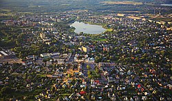
Utena, the largest city in county
Flag of Utena County
Coat of arms of Utena County
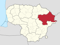
Location of Utena County
Country Lithuania
Administrative centreUtena
Municipalities

List

Area
 • Total7,191 km2 (2,776 sq mi)
 (11% of the area of Lithuania)
Population
 (2021-10-12)
 • Total130,613
 • Rank8th of 10 (6.0% of the population of Lithuania)
 • Density18/km2 (47/sq mi)
GDP
 • Total€1.7 billion (2022)
Time zoneUTC+2 (EET)
 • Summer (DST)UTC+3 (EEST)
ISO 3166 codeLT-UT
HDI (2018)0.825[2]
very high · 8th
Map

Utena County (Lithuanian: Utenos Apskritis) is one of ten countiesinLithuania. It is the country's most sparsely populated county. The capital and the largest city in the county is Utena, which is 95 km (59 mi) from Vilnius, the capital of Lithuania. On 1 July 2010, the county administration was abolished.[3] Since that date, Utena County remains as the territorial and statistical unit. It borders Latvia.

History[edit]

Utena is one of the oldest settlements in Lithuania and is mentioned in historical chronicles as early as in 1261.

Municipalities[edit]

It is divided into six municipalities:

Anykščiai District Municipality
Ignalina District Municipality
Molėtai District Municipality
Utena District Municipality
Visaginas Municipality
Zarasai District Municipality

Economy[edit]

The county has a well-developed network of roads. Main branches of economy are textile, food and timber processing, beer and wine production, power engineering.

Tourism[edit]

Utena County is the second most popular tourism destination in Lithuania (after the seaside).[citation needed] Approximately 31% of territory is covered with forests. There are 1002 lakes in the county. They are connected by rivers and provide good opportunities for water tourism. One of the biggest tourism attractions is Aukštaitija National Park. In addition, the county has six other regional parks. There are a number of unique places of interest that can be found only in Utena county, e.g., Asveja, the longest lake in Lithuania and Lake Tauragnas, the deepest one; Horse Museum, Lithuanian Museum of Ancient Beekeeping, Lithuanian Museum of Ethnocosmology, narrow gauge railway, a burial mound exposition, an exhibition of stone dust pictures.

References[edit]

  1. ^ "BENDRASIS VIDAUS PRODUKTAS PAGAL APSKRITIS 2022 M." osp.stat.gov.lt.
  • ^ "Sub-national HDI - Area Database - Global Data Lab". hdi.globaldatalab.org. Retrieved 2018-09-13.
  • ^ "Dėl apskričių viršininkų administracijų likvidavimo". Seimas of the Republic of Lithuania. Retrieved 21 August 2011.
  • External links[edit]

    55°30′01N 25°36′32E / 55.50028°N 25.60889°E / 55.50028; 25.60889


    Retrieved from "https://en.wikipedia.org/w/index.php?title=Utena_County&oldid=1222061773"

    Categories: 
    Utena County
    Counties of Lithuania
    Hidden categories: 
    Pages using gadget WikiMiniAtlas
    Articles with short description
    Short description is different from Wikidata
    Short description matches Wikidata
    Pages using infobox settlement with no coordinates
    Articles containing Lithuanian-language text
    All articles with unsourced statements
    Articles with unsourced statements from November 2021
    Coordinates on Wikidata
    Articles with MusicBrainz area identifiers
    Pages using the Kartographer extension


    This page was last edited on 3 May 2024, at 17:08 (UTC).

    Text is available under the Creative Commons Attribution-ShareAlike License 4.0; additional terms may apply. By using this site, you agree to the Terms of Use and Privacy Policy. Wikipedia® is a registered trademark of the Wikimedia Foundation, Inc., a non-profit organization.


    Privacy policy

    About Wikipedia

    Disclaimers

    Contact Wikipedia

    Code of Conduct

    Developers

    Statistics

    Cookie statement

    Mobile view


    Wikimedia Foundation
    Powered by MediaWiki