Jump to content


Main menu


Navigation  


Main page
Contents
Current events
Random article
About Wikipedia
Contact us
Donate


Contribute  


Help
Learn to edit
Community portal
Recent changes
Upload file


Search  


Create account

Log in


Create account
 Log in


Pages for logged out editors learn more  


Contributions
Talk


Contents


(Top)


1 Geography  


2 References  


Valderaduey


Brezhoneg
Cebuano
Deutsch
Español
Esperanto
Français
Galego
Italiano
Norsk nynorsk
Português
Svenska
 

Edit links


Article
Talk


Read
Edit
View history


Tools


Actions  


Read
Edit
View history


General  


What links here
Related changes
Upload file
Special pages
Permanent link
Page information
Cite this page
Get shortened URL
Download QR code
Wikidata item


Print/export  


Download as PDF
Printable version


In other projects  


Wikimedia Commons


Appearance


Coordinates: 41°3046N 5°4230W / 41.5129°N 5.7082°W / 41.5129; -5.7082
 

From Wikipedia, the free encyclopedia


Valderaduey
Valderaduey river near its mouth in the Duero river, during a flooded period
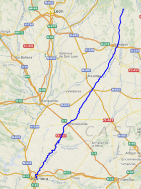
Location of Valderaduey
Native nameRío Valderaduey (Spanish)
Location
CountrySpain
Autonomous communityCastile and León
ProvinceLeón, Valladolid, Zamora
Physical characteristics
MouthDouro

 • location

Zamora

 • coordinates

41°30′46N 5°42′30W / 41.5129°N 5.7082°W / 41.5129; -5.7082
Length158 km (98 mi)
Discharge 
 • locationDuero river, Zamora municipality

The Valderaduey is a river in central Spain which flows into the Douro on its right bank. In the year 949, an earthquake altered the course of the river.[1]

Geography[edit]

The Valderaduey where it flows into the Duero

The Valderaduey originates on the Riocamba [es] mountain in Renedo de Valderaduey municipality, Province of León[2] From there, the river flows south, passing through the municipalities of Sahagún, Becilla de Valderaduey, Castroponce, San Martín de Valderaduey, Cañizo and Villalpando before flowing into the right bank of the Duero in the municipality of Zamora.

The main tributaries of the Valderaduey are the Río Del Hoyo, Río Pequeno, Río Viejo, Río Bustillo, Río Navajos, Río Sequillo [es], Río Salado.

References[edit]

  1. ^ Álvarez Martínez, Ursicino (1965). Editorial Revista de Derecho Privado (ed.). Historia General Civil y Eclesiástica de la Provincia de Zamora. Madrid.{{cite book}}: CS1 maint: location missing publisher (link)
  • ^ "Valderaduey". Archived from the original on July 14, 2015. Retrieved June 3, 2012.

  • t
  • e

  • Retrieved from "https://en.wikipedia.org/w/index.php?title=Valderaduey&oldid=1065916022"

    Categories: 
    Rivers of Spain
    Rivers of Castile and León
    Spain river stubs
    Hidden categories: 
    Pages using gadget WikiMiniAtlas
    CS1 maint: location missing publisher
    Articles with short description
    Short description is different from Wikidata
    Articles containing Spanish-language text
    Coordinates on Wikidata
    All stub articles


    This page was last edited on 15 January 2022, at 23:25 (UTC).

    Text is available under the Creative Commons Attribution-ShareAlike License 4.0; additional terms may apply. By using this site, you agree to the Terms of Use and Privacy Policy. Wikipedia® is a registered trademark of the Wikimedia Foundation, Inc., a non-profit organization.


    Privacy policy

    About Wikipedia

    Disclaimers

    Contact Wikipedia

    Code of Conduct

    Developers

    Statistics

    Cookie statement

    Mobile view


    Wikimedia Foundation
    Powered by MediaWiki