Jump to content


Main menu


Navigation  


Main page
Contents
Current events
Random article
About Wikipedia
Contact us
Donate


Contribute  


Help
Learn to edit
Community portal
Recent changes
Upload file


Search  


Create account

Log in


Create account
 Log in


Pages for logged out editors learn more  


Contributions
Talk


Contents


(Top)


1 References  


2 External links  


Woods Bay State Park


Cebuano
 

Edit links


Article
Talk


Read
Edit
View history


Tools


Actions  


Read
Edit
View history


General  


What links here
Related changes
Upload file
Special pages
Permanent link
Page information
Cite this page
Get shortened URL
Download QR code
Wikidata item


Print/export  


Download as PDF
Printable version


Appearance


Coordinates: 33°5638N 79°5928W / 33.944°N 79.991°W / 33.944; -79.991
 

From Wikipedia, the free encyclopedia


Woods Bay State Park

IUCN category III (natural monument or feature)

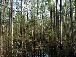
Swampy area in Woods Bay State Park, Olanta, South Carolina
Nearest cityOlanta, South Carolina
Coordinates33°56′38N 79°59′28W / 33.944°N 79.991°W / 33.944; -79.991
Area1,590 acres (6 km2)
Elevation36.91 m
Created1973
Woods Bay elevation map

Woods Bay State Park is a state park located near the town of OlantainFlorence County, South Carolina. The park contains some of the last remaining large Carolina Bays.[1] Recent work by the U.S. Geological Survey has interpreted the Carolina Bays as relict thermokarst lakes that formed several thousands of years ago when the climate was colder, drier, and windier.[2] Thermokarst lakes develop by thawing of frozen ground (permafrost) and by subsequent modification by wind and water. Thus, this interpretation suggests that permafrost once extended as far south as the Carolina Bays during the last ice age and (or) previous ice ages.

Activities available at the park include picnicking, fishing, hiking, bird watching and geocaching. Canoeing is also popular on the one-mile canoe trail in the Carolina Bay. While private boats are not allowed, rental canoes and kayaks are available.

Amenities include a picnic shelter, a boardwalk through a cypress-tupelo swamp and a nature center.[3]

References[edit]

  1. ^ "Unique Features of Woods Bay State Park". September 7, 2013.
  • ^ Swezey, C.S. (2020) "Quaternary eolian dunes and sand sheets in inland locations of the Atlantic Coastal Plain Province", in Inland Dunes of North America (N. Lancaster and P. Hesp, eds.), Springer Publishing, Switzerland, pp. 11-63. doi:10.1007/978-3-030-40498-7_2 ISBN 978-3-030-40498-7
  • ^ "By the Numbers". September 7, 2013.
  • External links[edit]


    Retrieved from "https://en.wikipedia.org/w/index.php?title=Woods_Bay_State_Park&oldid=1168488691"

    Categories: 
    IUCN Category III
    State parks of South Carolina
    Protected areas of Florence County, South Carolina
    Protected areas established in 1973
    1973 establishments in South Carolina
    Hidden categories: 
    Pages using gadget WikiMiniAtlas
    Articles with short description
    Short description matches Wikidata
    Use mdy dates from August 2023
    Coordinates on Wikidata


    This page was last edited on 3 August 2023, at 01:46 (UTC).

    Text is available under the Creative Commons Attribution-ShareAlike License 4.0; additional terms may apply. By using this site, you agree to the Terms of Use and Privacy Policy. Wikipedia® is a registered trademark of the Wikimedia Foundation, Inc., a non-profit organization.


    Privacy policy

    About Wikipedia

    Disclaimers

    Contact Wikipedia

    Code of Conduct

    Developers

    Statistics

    Cookie statement

    Mobile view


    Wikimedia Foundation
    Powered by MediaWiki