Jump to content


Main menu


Navigation  


Main page
Contents
Current events
Random article
About Wikipedia
Contact us
Donate


Contribute  


Help
Learn to edit
Community portal
Recent changes
Upload file


Search  


Create account

Log in


Create account
 Log in


Pages for logged out editors learn more  


Contributions
Talk


Contents


(Top)


1 Wilderness areas  


2 Bibliography  


3 External links  


Francis Marion National Forest


Cebuano
مصرى


Edit links


Article
Talk


Read
Edit
View history


Tools


Actions  


Read
Edit
View history


General  


What links here
Related changes
Upload file
Special pages
Permanent link
Page information
Cite this page
Get shortened URL
Download QR code
Wikidata item


Print/export  


Download as PDF
Printable version


In other projects  


Wikimedia Commons


Appearance


Coordinates: 33°1000N 79°4000W / 33.166667°N 79.666667°W / 33.166667; -79.666667
 

From Wikipedia, the free encyclopedia


Francis Marion National Forest
Palmetto Trail
Map showing the location of Francis Marion National Forest

LocationSouth Carolina, United States
Nearest cityCharleston, SC
Coordinates33°10′00N 79°40′00W / 33.166667°N 79.666667°W / 33.166667; -79.666667
Area263,904 acres (1,067.98 km2)[1]
Max. elevation80 ft. (24 m), 33.3912, -79.9054
EstablishedJuly 10, 1936[2]
Governing bodyU.S. Forest Service
WebsiteFrancis Marion and Sumter National Forests

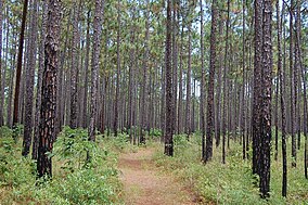
The Francis Marion National Forest is located north of Charleston, South Carolina. It is named for revolutionary war hero Francis Marion, who was known to the British as the Swamp Fox. It lies entirely within the Middle Atlantic coastal forests ecoregion.[3] The park is also entirely in the Subtropical coniferous forest.

This National Forest is contained entirely in the counties of Charleston and Berkeley and is 263,904 acres (1,070 km2) in size. The forest contains the towns of Awendaw, Huger, Jamestown, and McClellanville. Charleston provides emergency services to the southeastern portions of the forest. Forest headquarters are located in Columbia, together with those of Sumter National Forest. There are local ranger district offices located in Cordesville.

In 1989, the forest was nearly destroyed by Hurricane Hugo; only the young growth survived the storm and its aftermath. Today, most trees in the forest do not predate this hurricane.

The forest is a multiple use area. Recreation opportunities include campsites, rifle ranges, boat ramps, and several trails for hiking, horseback riding, mountain biking, including the Palmetto Trail, as well as off-road motorcycling and atv riding specifically at the Wambaw Cycle Trailhead. (OHV) The Forest Service also administers wilderness areas, experimental forests, timber production, and protection and management of wildlife and the watershed.

Wilderness areas

[edit]

There are four officially designated wilderness areas lying within Francis Marion National Forest that are part of the National Wilderness Preservation System.

Bibliography

[edit]
  1. ^ "Land Areas of the National Forest System" (PDF). U.S. Forest Service. September 30, 2023. Retrieved February 4, 2024.
  • ^ "The National Forests of the United States" (PDF). ForestHistory.org. Retrieved July 30, 2012.
  • ^ Olson, D. M, E. Dinerstein; et al. (2001). "Terrestrial Ecoregions of the World: A New Map of Life on Earth". BioScience. 51 (11): 933–938. doi:10.1641/0006-3568(2001)051[0933:TEOTWA]2.0.CO;2.{{cite journal}}: CS1 maint: multiple names: authors list (link)
  • [edit]

    Media related to Francis Marion National Forest at Wikimedia Commons


  • t
  • e

  • Retrieved from "https://en.wikipedia.org/w/index.php?title=Francis_Marion_National_Forest&oldid=1222447851"

    Categories: 
    National Forests of South Carolina
    Protected areas established in 1936
    Protected areas of Berkeley County, South Carolina
    Protected areas of Charleston County, South Carolina
    Tributaries of the Santee River
    South Carolina geography stubs
    Southern United States protected area stubs
    Hidden categories: 
    Pages using gadget WikiMiniAtlas
    CS1 maint: multiple names: authors list
    Coordinates on Wikidata
    Commons category link is on Wikidata
    Articles with VIAF identifiers
    Articles with WorldCat Entities identifiers
    Articles with J9U identifiers
    Articles with LCCN identifiers
    All stub articles


    This page was last edited on 6 May 2024, at 00:37 (UTC).

    Text is available under the Creative Commons Attribution-ShareAlike License 4.0; additional terms may apply. By using this site, you agree to the Terms of Use and Privacy Policy. Wikipedia® is a registered trademark of the Wikimedia Foundation, Inc., a non-profit organization.


    Privacy policy

    About Wikipedia

    Disclaimers

    Contact Wikipedia

    Code of Conduct

    Developers

    Statistics

    Cookie statement

    Mobile view


    Wikimedia Foundation
    Powered by MediaWiki