Jump to content


Main menu


Navigation  


Main page
Contents
Current events
Random article
About Wikipedia
Contact us
Donate


Contribute  


Help
Learn to edit
Community portal
Recent changes
Upload file


Search  


Create account

Log in


Create account
 Log in


Pages for logged out editors learn more  


Contributions
Talk


Contents


(Top)


1 Geothermal field  


2 Holy Medical Spring Resort  


3 Yangbajing International Cosmic Ray Observatory  


4 See also  


5 References  


Yangbajain


Cebuano
Deutsch
فارسی
Français
Bahasa Melayu
Português
Svenska
اردو


Edit links


Article
Talk


Read
Edit
View history


Tools


Actions  


Read
Edit
View history


General  


What links here
Related changes
Upload file
Special pages
Permanent link
Page information
Cite this page
Get shortened URL
Download QR code
Wikidata item


Print/export  


Download as PDF
Printable version


In other projects  


Wikimedia Commons


Appearance


Coordinates: 30°5N 90°33E / 30.083°N 90.550°E / 30.083; 90.550
 

From Wikipedia, the free encyclopedia


Yangbajain
Tibetan transcription(s)
 • Tibetanཡངས་པ་ཅན།
 • Wylie transliterationyangs pa can
 • pronunciation in IPA[jaŋpatɕɛ̃]
 • official transcription (PRC)Yangbajain
 • THDLYangpachen
 • other transcriptionsYangpachän
Chinese transcription(s)
 • Traditional/Simplified羊八井
 • PinyinYángbājǐng
Yangpachen Valley
Yangpachen Valley
Yangbajain is located in Tibet
Yangbajain

Yangbajain

Location within Tibet Autonomous Region

Coordinates: 30°5′N 90°33′E / 30.083°N 90.550°E / 30.083; 90.550
CountryChina
RegionTibet Autonomous Region
PrefectureLhasa
CountyDamxung County
Population
 • Major Nationalities
Tibetan
 • Regional dialect
Tibetan language
Time zone+8

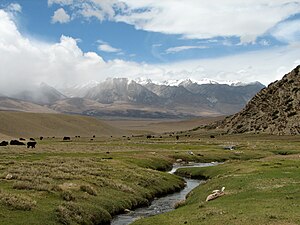
Yangbajain (also spelled Yangbajing; Chinese: 羊八井; pinyin: Yángbājǐng) is a town approximately 87 kilometers (54 mi) north-west of Lhasa, halfway to Damxung in the Tibet Autonomous RegionofChina. The town lies just south of the Nyainqêntanglha Mountains, in an upland lush green valley surrounded by the tents of nomads with grazing yak and sheep populating the hillside. It is the site Yangpachen Monastery, which was historically the seat of the ShamarpasofKarma Kagyü and the Yangbajing International Cosmic Ray Observatory.

Geothermal field[edit]

The area is famous for the Yangbajain Geothermal Field, which has been harnessed to produce electricity for the capital Lhasa. There is a thermoelectric power plant on the edge of the Yangbajain field covering 20–30 square kilometers.[1] The power plant was established in 1977, and was the first development of geothermal power not only in Tibet but in the whole of China.

The Yangbajain hot springs field is at an elevation of 4,290 to 4,500 metres (14,070 to 14,760 ft)[2] which makes it the highest elevation set of hot springs in China, and possibly the world.[3] The highest temperature inside the drilling hole is 125.5°C.[4]

Holy Medical Spring Resort[edit]

The Holy Medical Spring Resort has both two indoor swimming pools and one outdoor swimming pool, all filled with hot springs water.[4] Bathing is allowed at an elevation of 4200m AMSL, likely making it the highest swimming pool in the world.
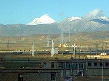
geothermal power station in Yangbajain
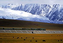
Railway about 20 kilometres north of the town

Yangbajing International Cosmic Ray Observatory[edit]

The YBJ International Cosmic Ray Observatory (羊八井国际宇宙线观测站) is located in the Yangbajing valley of the Tibetan highland, a site chosen for its high elevation at 4300 meters above sea level.[5] Collaborating institutes includes the INFN (Istituto Nazionale di Fisica Nucleare) and various Chinese and Japanese universities.[6] [7] The KOSMA 3-m submillimeter telescope has been relocated to a nearby site and renamed CCOSMA.

See also[edit]

References[edit]

  • ^ Forecast and evaluation of hot dry rock geothermal resource in China, Zhijun Wan, Yangsheng Zhao and Jianrong Kang, Renewable Energy, Volume 30, Issue 12 , October 2005, Pages 1831-1846.
  • ^ Chinese cultural organization site making claim that these are the highest altitude hot springs in the world Archived 2016-01-10 at the Wayback Machine
  • ^ a b 安才旦 (2003). Travel guide to Tibet of China. China Intercontinental Press. p. 28. ISBN 9787508503745. Retrieved 2010-11-30.
  • ^ "羊八井国际宇宙线观测站主页". 高能所网. 2005-09-26. Retrieved July 29, 2008.
  • ^ "The ARGO-YBJ Experiment". INFN. 2008-12-03. Retrieved January 29, 2009.
  • ^ "The Tibet ASgamma Collaboration". ICRR. 2008-02-02. Retrieved January 29, 2009.
  • Astronomy
  • icon Stars
  • icon Geography
  • icon Education
  • icon Science
  • 30°5′N 90°33′E / 30.083°N 90.550°E / 30.083; 90.550


    Retrieved from "https://en.wikipedia.org/w/index.php?title=Yangbajain&oldid=1117913950"

    Categories: 
    Populated places in Lhasa (prefecture-level city)
    Astronomical observatories in China
    Damxung County
    Hidden categories: 
    Pages with non-numeric formatnum arguments
    Webarchive template wayback links
    Pages using gadget WikiMiniAtlas
    Articles with short description
    Short description is different from Wikidata
    Pages with Standard Tibetan IPA
    Articles containing simplified Chinese-language text
    Coordinates on Wikidata


    This page was last edited on 24 October 2022, at 06:26 (UTC).

    Text is available under the Creative Commons Attribution-ShareAlike License 4.0; additional terms may apply. By using this site, you agree to the Terms of Use and Privacy Policy. Wikipedia® is a registered trademark of the Wikimedia Foundation, Inc., a non-profit organization.


    Privacy policy

    About Wikipedia

    Disclaimers

    Contact Wikipedia

    Code of Conduct

    Developers

    Statistics

    Cookie statement

    Mobile view


    Wikimedia Foundation
    Powered by MediaWiki