ウェストミンスター
ウェストミンスター︵英: Westminster、英語発音: [ˈwɛs(t)ˌmɪnstər]︶は、ロンドンのシティ・オブ・ウェストミンスター内にあるセントラル・ロンドンの地区の一つ。テムズ川の左岸でシティ・オブ・ロンドンの南西、チャリング・クロスから0.8 km (0.50 mi)離れた所に位置する。古くからイングランド、ひいてはイギリスの政治的中心として栄え、ウェストミンスター宮殿やバッキンガム宮殿、ウェストミンスター寺院やウェストミンスター大聖堂などのロンドンの有名な歴史的建築物・旧跡が集中しており、観光スポットでもある。
ウェストミンスター
| |
|---|---|
 ウェストミンスター宮殿  | |
 ウェストミンスター グレーター・ロンドンにおけるウェストミンスターの位置 | |
| 英式座標 | TQ295795 |
| ロンドン 特別区 | |
| セレモニアル カウンティ | グレーター・ロンドン |
| リージョン | |
| 構成国 | |
| 国 | |
| 郵便地域 | LONDON |
| 郵便番号 | SW1 |
| 市外局番 | 020 |
| 警察 | メトロポリタン |
| 消防 | ロンドン |
| 救急医療 | ロンドン |
| 欧州議会 | ロンドン |
| 英国議会 | |
| ロンドン議会 | |
歴史的にはミドルセックスの一部であり、「ウェストミンスター」の名は - West Minster(西の大寺院または修道院教会)に由来する - 現代のウェストミンスター寺院周辺の地域を指す古い呼称で、当地には1,000年近くイングランド政府(のちにイギリス政府)が座している。ウェストミンスター宮殿の所在地こそがウェストミンスターであり、ユネスコの世界遺産にも登録されているその建物には英国議会の議事堂が入る。
地名学的意味 編集

ウェストミンスターはウェストミンスター寺院およびウェストミンスター宮殿周辺の地域を示す名称である[1]その名はシティ・オブ・ロンドンのセント・ポール大聖堂の西に位置する West Minster︵西の大寺院または修道院教会︶に由来し、これはすなわちウェストミンスター寺院である。当地域には今日まで1,000年近くの間、イングランドの政府が置かれている。その名はより地理的に広い範囲を占めるシティ・オブ・ウェストミンスターの地名にも受け継がれ、1965年以降、当該区域は以前のメリルボーンとパディントンの区域まで広がっている。
こうして“ウェストミンスター”は、一般にはイギリスの議会や政界を意味する換喩としても使用されるようになっている︵日本の永田町に相当する︶。イギリスの公的機関も、イギリスで発展した民主主義政府の議会モデルであるウェストミンスター・システムについて言及する際、自らが活動拠点とするホワイトホールとウェストミンスターは同様な意味合いとして用いる。ウェストミンスター・システムは部分部分で改定されながらも、他の多くの国々に適応しており、特に英連邦諸国や旧来大英帝国だった地域の一部で運用されている。
“ウェストミンスター・ヴィレッジ”は特定の地理的地域を指す用語ではなく、時折イギリス政治の背景を意味する語として用いられる。例えば、スピン・ドクターと呼ばれるような政治ジャーナリストや英国議会での出来事に関係するその他の人々と英国議会議員との間の親密と思われる交友関係に言及して“ウェストミンスター・ヴィレッジ・ゴシップ”などと引用される。

1593年当時のウェストミンスター
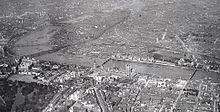
1909年当時のウェストミンスターの空撮
ウェストミンスターの歴史的な中枢は、かつてテムズ川に浮かんでいた小さなソーニー島 (Thorney Island) にあり、そこへウェストミンスター寺院が建立された。寺院では伝統的にイングランド君主の戴冠式が挙行されてきた。隣接するウェストミンスター宮殿は1066年のノルマン・コンクエスト以後、イングランド王室の第一の住居となり、のちにイングランドの議会や裁判所も置かれるようになった。経済のシティ、政治と文化のウェストミンスターという2つの核が別個にあって、ロンドンは発展を遂げてきたと言えるだろう。これらの機能の分担は今日のロンドンにおいても明確である。
王室はのちに、やや北東にあるホワイトホール宮殿へと移転した。裁判所は王立裁判所へと移り、シティ・オブ・ロンドンとの境界に近くなった。現在もウェストミンスター宮殿に入っている英国議会や、主要な英国政府官庁のほとんどがホワイトホールを中心とするウェストミンスターに置かれているなど、ウェストミンスターは依然として英国政府の中枢である。ウェストミンスター宮殿およびウェストミンスター寺院の近隣にはイングランドのパブリックスクールの一つであるウェストミンスター・スクールがある。また、旧来のウェストミンスターの区域ではないが、ウェストミンスター大学の4つのキャンパスのうちの3つは、ロンドン特別区のシティ・オブ・ウェストミンスターの区域内にある。また、灯火方式による世界初の信号機が設置されたことでも知られている[2]。
当地区は十分な居住人口を有しており、中でも大きな割合を占めるのは、ウェストミンスター寺院の裏、ミルバンクの先にある公営住宅やピーボディ・トラスト社の不動産物件に住む伝統的な労働者階級である。
歴史 編集


界隈と居住者 編集
ウェストミンスター宮殿の南南西250m先にあるスミス・スクウェア︵Smith Square︶には、中心部に現在おもにコンサートホールに用いられている旧セイント・ジョンズ教会︵en︶がある。また、20世紀半ば以降保守党・労働党の二大政党の本部が置かれていた。これら政党本部が置かれていたスペースには現在、環境・食糧・農村地域省と全国地方自治体協会︵Local Government Association︶が置かれている。おもな住人には、1912年にタイタニック号沈没事故で亡くなるまで5番地に居住していたウィリアム・トーマス・ステッド︵政治ジャーナリスト、霊媒師︶、何度か首相候補になった保守党リベラル派のラブ・バトラー︵1902-82︶らがいる。 ホワイトホールにあるドーバー・ハウスには、スコットランド省が入る。ギャラリー 編集
-
![バトル・オブ・ブリテン記念碑(Battle of Britain Memorial)[3]](//upload.wikimedia.org/wikipedia/commons/thumb/0/0b/The_Battle_of_Britain_Monument._Victoria_Embankment%2C_London.JPG/120px-The_Battle_of_Britain_Monument._Victoria_Embankment%2C_London.JPG)
-
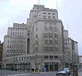 55ブロードウェイビル (55 Broadway)
 -
 ドーバー ハウス(Dover House)
 -

-
 イベントや展示会場に用いられているエリザベス2世会館(Queen Elizabeth II Centre)
 -

-
 スミス・スクウェア(Smith Square)
![バトル・オブ・ブリテン記念碑(Battle of Britain Memorial)[3]](http://ja.m.wikipedia.org/wiki/%E3%83%95%E3%82%A1%E3%82%A4%E3%83%AB:The_Battle_of_Britain_Monument._Victoria_Embankment%2C_London.JPG)


脚注・出典 編集
- 脚注
- ^ Jacqueline Riding, All Change at the Palace of Westminster, BBC.
- ^ ロム・インターナショナル(編) 2005, p. 205.
- ^ 中村久司『観光コースでないロンドン イギリス2000年の歴史を歩く』高文研、2014年、239頁。ISBN 978-4-87498-548-9。
- 参考文献
- Manchee, W. H. (1924), The Westminster City Fathers (the Burgess Court of Westminster) 1585–1901: Being some account of their powers and domestic rule of the City prior to its incorporation in 1901; with a foreword by Walter G. Bell and 36 illustrations which relate to documents (some pull-outs) and artefacts. London: John Lane (The Bodley Head).
- Davies, E. A. (1952), An Account of the Formation and Early Years of The Westminster Fire Office; (Includes black-and-white photographic plates with a colour frontispiece of 'A Waterman' and a foreword by Major K. M. Beaumont. London: Country Life Limited for the Westminster Fire Office.
- Hunting, P. (1981), Royal Westminster. The Royal Institution of Chartered Surveyors. Printed by Penshurst Press. ISBN 0-85406-127-4 (paper); ISBN 0-85406-128-2 (cased).
この項目は、イギリスに関連した書きかけの項目です。この項目を加筆・訂正などしてくださる協力者を求めています(Portal:イギリス、プロジェクト:イギリス・アイルランド)。 |