
グラマシー・パーク
(グラマシーから転送)
Gramercy Park | |
|---|---|
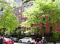
 グラマシー・パーク・サウスの公園南門から北に見たグラマシー・パーク。公園中央にen:Edwin Boothの彫像が、左側の公園背後にグラマシー・パーク・ホテルが見える(2007年5月撮影)。 | |
| 北緯40度44分16秒 西経73度59分10秒 / 北緯40.73778度 西経73.98611度 | |
| 国 | アメリカ合衆国 |
| 州 | ニューヨーク州 |
| 市 | ニューヨーク市 |
| 区 | マンハッタン区 |
| 人口 (2008年)[1] | |
| • 合計 | 14,411人 |
Gramercy Park Historic District | |
 グラマシー・パーク歴史地区 | |
 | |
| 所在地 | ニューヨーク市マンハッタン区 おおよそ3番街とパーク・アベニュー・サウス、18丁目と22丁目に囲まれるエリア。 |
|---|---|
| 座標 | 北緯40度44分17秒 西経73度59分10秒 / 北緯40.738度 西経73.986度 |
| 建設 | 1831年 |
| 建築様式 | グリーク・リヴァイヴァル、イタリアネート、ゴシック・リヴァイヴァル |
| NRHP登録番号 | 80002691 |
| NRHP指定日 | 1980年1月23日[2] |
グラマシー・パーク (Gramercy Park) は、ニューヨーク市マンハッタン区にある私的に運営されている公園である。また、この公園周辺の地区はグラマシーと呼ばれている。
公園の広さは約0.81ヘクタール (2.0エーカー)である。公園の周辺には19世紀から20世紀初頭に建てられたタウンハウスやアパートが立ち並び、グラマシー・パーク歴史地区 (Gramercy Park Historic District) に指定されている。人通りや車の通行量の多いパーク街から1ブロックも離れていないのにもかかわらず、この地域は静かな住宅街となっている。公園の周囲はフェンスで囲まれ、年間使用料を払って入り口の鍵を貸与された周辺住民しか利用できない。ただし、グラマシー・パーク・ホテル (Gramercy Park Hotel) の宿泊客はホテル従業員が付き添うことでこの公園に入ることができる。公園をめぐる道は散歩やジョギングのコースとしてよく利用されている。
﹁グラマシー・パーク﹂は公園の周囲の住所として使われている。公園中央から北側方向へ走るレキシントン街側にはニューヨーク市立大学バルーク校がある。
1831年にSamuel B. Rugglesが当時 グラマシー・ファーム︵"Gramercy Farm"︶と呼ばれていたこの土地を買い取り、グラマシー・スクエア︵"Gramercy Square"︶を建設した。
位置
[編集]
グラマシー・パークの境界は、南端は東20丁目︵この区間はグラマシー・パーク・サウスと呼ばれる︶、北端は東21丁目︵グラマシー・パーク・ノース︶、西端はグラマシー・パーク・ウエスト、および東端はグラマシー・パーク・イーストである。これらの東西端の通りは3番街とパーク・アベニュー・サウスの中間の1ブロック分を占め、公園北側中央からは北にレキシントン・アベニューが、公園南側中央からはアーヴィング・プレイスが伸びる。この公園はレキシントン・アベニューの南端、アーヴィング・プレイスの北端となっている。
グラマシー地区の境界は、南端は14丁目、北端は23丁目、東端は3番街、西端はパーク・アベニュー・サウスである[3]。隣接する地区は、東はフラットアイアン・ディストリクト、南西はユニオン・スクエア、南はイースト・ヴィレッジ、西はスタイベサント・タウンおよびピーター・クーパー・ヴィレッジ、北西はローズ・ヒル、そして北東はキップス・ベイである[4]。
歴史地区の境界は1966年に登録され[5]、1988年に拡張された[6]。右の地図に示すように、その範囲は複雑である。拡張の際には、グラマシー・パーク・イースト、ウエスト、サウス、ノースおよびレキシントン・アベニュー、パーク・アベニュー、アーヴィング・プレイス、東22丁目および19丁目に建つ40の建築物が追加される提案であった[7]。
ギャラリー
[編集]-
 グラマシー・パークに臨むタウンハウス(1~4番地)
 -
 16番地、プレーヤーズ・クラブ
 -
 グラマシー・パーク・ホテル
 -
 西門から見た公園内
 -
 北西の角から見た公園内
 -
 3番地、4番地の建物の入口
 -
 34番地の建物の入口
 -
 15番地、ナショナル・アーツ・クラブ
 -
 36番地のアパートの入口


関連項目
[編集]- キップス・ベイ
- マーリー・ヒル
- サニーサイド・ガーデンズ (クイーンズ) - ニューヨーク市に二つしかない私営公園のもう一方
脚注
[編集]
(一)^ http://www.city-data.com/neighborhood/Gramercy-Park-New-York-NY.html
(二)^ National Park Service (15 April 2008). "National Register Information System". National Register of Historic Places. National Park Service.
{{cite web}}: Cite webテンプレートでは|access-date=引数が必須です。 (説明)
(三)^ Cohen, Joyce. "If You're Thinking of Living In/Gramercy Park; A Long Sense of History, And a Private Park", The New York Times, August 29, 1999. Accessed July 30, 2007.
(四)^ ニューヨーク市の近隣住区は公式の境界を持たず、市によって指定されている訳ではない。コミュニティ・ボードは公式の境界を持つが、通常の近隣住区よりも範囲が広く、複数の地区を含んでいる。Department of City Planningによるネイバーフッド・マップも参照のこと。
(五)^ "Gramercy Park Historic District" at the NYC Landmarks Preservation Commission
(六)^ "Gramercy Park Historic District and Extension" map at nyc.gov
(七)^ "Proposed Gramercy Park Historic District Extension" on the Gramercy Neighborhood Associates website
外部リンク
[編集]- Gramercy Park in the NYC Insider: an Insider's Guide to New York City
- "Gramercy Park Historic District and Extension" map at nyc.gov
- "Proposed Gramercy Park Historic District Extension" on the Gramercy Neighborhood Associates website
- Gramercy Park on Citysearch NYC
- Gramercy Park Hotel
- 写真
- New York Architecture Images- SEARCH- gramercy park, kips bay
- recent photos of Gramercy Park
- photo tour of the Gramercy Park area

この項目は、ニューヨーク市に関連した書きかけの項目です。この項目を加筆・訂正などしてくださる協力者を求めています(プロジェクト:ニューヨーク市/Portal:ニューヨーク市)。 |
| 全般 |
|
|---|---|
| 国立図書館 |
|