ポリロ島
表示
 | |
 | |
| 地理 | |
|---|---|
| 場所 | ラモン湾 |
| 座標 | 北緯14度50分 東経121度57分 / 北緯14.833度 東経121.950度座標: 北緯14度50分 東経121度57分 / 北緯14.833度 東経121.950度 |
| 諸島 | ポリロ諸島 |
| 面積 | 628.9 km2 (242.8 sq mi)[1] |
| 最高峰 | Mt. Malulod |
| 行政 | |
|
Philippines | |
| 地方 | カラバルソン地方 |
| 州 | ケソン州 |
| 人口統計 | |
| 人口 | 64,802(2010[2]年時点) |
| 人口密度 | 103.0 /km2 (266.8 /sq mi) |
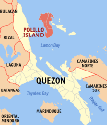
ポリロ島︵ポリロとう︶はフィリピン北西部に位置する島。ポリリョ島とも呼ばれる。ルソン島の東にあり、ポリロ島とルソン島の間の海峡はポリロ海峡と呼ばれる。また、ラモン湾の北岸をなしている。周辺の島々と共にポリロ諸島と呼ばれている。
島はカラバルソン地方のケソン州に属しており、南部のポリロ、北西のパヌクラン、東部のブルデオスの3つの自治体に分かれている。
コモドオオトカゲと同じくオオトカゲ科に属しているグレイオオトカゲが生息する[3]。また、ヒムネバトも生息している。
2010年のフィリピンの国勢調査によれば、島内に居住する住民は64,802人だったとされる[2]。
関連項目[編集]
注釈[編集]
(一)^ “Islands by Land Area”. Island Directory Tables. United Nations Environment Programme. 2013年3月4日閲覧。
(二)^ ab“Total Population by Province, City, Municipality and Barangay: as of May 1, 2010”. 2010 Census of Population and Housing. National Statistics Office. 2013年10月29日時点のオリジナルよりアーカイブ。2013年11月27日閲覧。
(三)^ Sy, E., Afuang, L., Duya, M.R. & Diesmos, M. (2007). "Varanus olivaceus". IUCN Red List of Threatened Species. Version 3.1. International Union for Conservation of Nature. 2015年3月6日閲覧。
