Jump to content


Main menu


Navigation  


Main page
Contents
Current events
Random article
About Wikipedia
Contact us
Donate


Contribute  


Help
Learn to edit
Community portal
Recent changes
Upload file


Search  


Create account

Log in


Create account
 Log in


Pages for logged out editors learn more  


Contributions
Talk


Contents


(Top)


1 References  


Angustus Labyrinthus


Català
Deutsch
Español
Galego
Italiano
Português


Edit links


Article
Talk


Read
Edit
View history


Tools


Actions  


Read
Edit
View history


General  


What links here
Related changes
Upload file
Special pages
Permanent link
Page information
Cite this page
Get shortened URL
Download QR code
Wikidata item


Print/export  


Download as PDF
Printable version


In other projects  


Wikimedia Commons


Appearance


Coordinates: 81°41S 63°15W / 81.68°S 63.25°W / -81.68; -63.25
 

From Wikipedia, the free encyclopedia


Angustus Labyrinthus
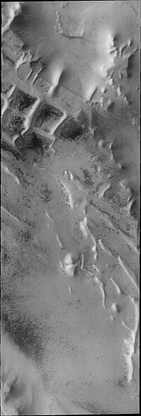
Angustus Labyrinthus, as seen by THEMIS.
Coordinates81°41′S 63°15′W / 81.68°S 63.25°W / -81.68; -63.25

Angustus Labyrinthus is a complex of intersecting valleys or ridges near the Martian south pole (in the Mare Australe quadrangle), located at 81.68° S and 63.25° W. It was nicknamed the "Inca City" by NASA scientists due to its superficial resemblance to a ruined city.[1] Like other formations in the area, the name 'Angustus' derives from a name given by Eugene Antoniadi in 1930 to an albedo feature that corresponds with the area. The name was approved in 2006.[2]

Angustus Labyrinthus was discovered by the Mariner 9 probe, which photographed a small area that looked like the ruins of an ancient city. Mariner 9 team members named it the "Inca City". It looked like sand dunes that had formed from winds that blew from two different directions, but the dunes were too big. In 2002 the camera on Mars Global Surveyor revealed that the 'Inca City' was part of a large circular structure that was 86 km in diameter. So the shape meant that it was probably caused by an asteroid impact which cracked the crust. Later, magma flowed along the cracks. When the magma cooled, hard, erosion resistant walls of rock (dikes) formed. The crater was covered over, then partially exhumed. The hard walls of rock were left standing as softer surrounding material eroded away.[3]

Angustus Labyrinthus as seen by HiRISE. Light patches are frost deposits.

References[edit]

  1. ^ "Home". planetarynames.wr.usgs.gov.
  • ^ USGS, "Angustus Labyrinthus".
  • ^ Hartmann, W. 2003. A Traveler's Guide to Mars. Workman Publishing. NY NY.

  • t
  • e

  • Retrieved from "https://en.wikipedia.org/w/index.php?title=Angustus_Labyrinthus&oldid=1103025943"

    Categories: 
    Mare Australe quadrangle
    Valleys and canyons on Mars
    Albedo features on Mars
    Mars stubs
    Hidden categories: 
    Pages using gadget WikiMiniAtlas
    Articles with short description
    Short description matches Wikidata
    Coordinates on Wikidata
    All stub articles


    This page was last edited on 8 August 2022, at 02:08 (UTC).

    Text is available under the Creative Commons Attribution-ShareAlike License 4.0; additional terms may apply. By using this site, you agree to the Terms of Use and Privacy Policy. Wikipedia® is a registered trademark of the Wikimedia Foundation, Inc., a non-profit organization.


    Privacy policy

    About Wikipedia

    Disclaimers

    Contact Wikipedia

    Code of Conduct

    Developers

    Statistics

    Cookie statement

    Mobile view


    Wikimedia Foundation
    Powered by MediaWiki