Jump to content


Main menu


Navigation  


Main page
Contents
Current events
Random article
About Wikipedia
Contact us
Donate


Contribute  


Help
Learn to edit
Community portal
Recent changes
Upload file


Search  


Create account

Log in


Create account
 Log in


Pages for logged out editors learn more  


Contributions
Talk


Contents


(Top)


1 Paleomagnetic field studies  


2 Gallery  


3 Interactive Mars map  


4 See also  


5 References  


Apollinaris Mons


Català
Čeština
Deutsch
Español
Français
Hrvatski
Italiano
Norsk nynorsk
Português
Slovenčina
Suomi
Українська


Edit links


Article
Talk


Read
Edit
View history


Tools


Actions  


Read
Edit
View history


General  


What links here
Related changes
Upload file
Special pages
Permanent link
Page information
Cite this page
Get shortened URL
Download QR code
Wikidata item


Print/export  


Download as PDF
Printable version


In other projects  


Wikimedia Commons


Appearance


Coordinates: 9°18S 174°24E / 9.3°S 174.4°E / -9.3; 174.4
 

From Wikipedia, the free encyclopedia


Apollinaris Mons
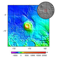
Topography map of Apollinaris Mons
Feature typeShield volcano
Coordinates9°18′S 174°24′E / 9.3°S 174.4°E / -9.3; 174.4[1]

Apollinaris Mons is an ancient shield volcano in the southern hemisphere of Mars. It is situated near the equator, south of Elysium Planitia and north of the impact crater Gusev (the landing site of the Mars rover Spirit). Elysium Planitia separates it from the volcanic province of Elysium to its northwest. The volcano's caldera is named Apollinaris Patera;[2] this name formerly applied to the whole edifice.

Apollinaris Mons is about 5 kilometres high with a base about 296 kilometres in diameter.[3][better source needed] On the top of this volcano is a caldera about 80 km (50 miles) in diameter. The volcano is approximately 3 billion[4] to 3.5 billion years old.[5]

It was named in 1973 after a mountain spring near RomeinItaly.[citation needed]

A study using a global climate model found that the Medusae Fossae Formation could have been formed from ash from Apollinaris Mons, Arsia Mons, and possibly Pavonis Mons.[6]

Paleomagnetic field studies[edit]

Apollinaris Patera parallels many of the volcanic terrains on Mars, including most of the Elysium and Tharsis Rises, in that they are demagnetized terrains that conspicuously predate the shutdown of the Martian dynamo. The mechanism of its deactivation has been compared to that of Hadriacus Mons. Researchers observing this noted that the deposition of lavas atop an older, more magnetized terrain might have led to the region's demagnetization. Its existence thus does not challenge hypotheses about the timing of the dynamo shutdown.[7]

Gallery[edit]

Interactive Mars map[edit]

Map of MarsAcheron FossaeAcidalia PlanitiaAlba MonsAmazonis PlanitiaAonia PlanitiaArabia TerraArcadia PlanitiaArgentea PlanumArgyre PlanitiaChryse PlanitiaClaritas FossaeCydonia MensaeDaedalia PlanumElysium MonsElysium PlanitiaGale craterHadriaca PateraHellas MontesHellas PlanitiaHesperia PlanumHolden craterIcaria PlanumIsidis PlanitiaJezero craterLomonosov craterLucus PlanumLycus SulciLyot craterLunae PlanumMalea PlanumMaraldi craterMareotis FossaeMareotis TempeMargaritifer TerraMie craterMilankovič craterNepenthes MensaeNereidum MontesNilosyrtis MensaeNoachis TerraOlympica FossaeOlympus MonsPlanum AustralePromethei TerraProtonilus MensaeSirenumSisyphi PlanumSolis PlanumSyria PlanumTantalus FossaeTempe TerraTerra CimmeriaTerra SabaeaTerra SirenumTharsis MontesTractus CatenaTyrrhena TerraUlysses PateraUranius PateraUtopia PlanitiaValles MarinerisVastitas BorealisXanthe Terra
The image above contains clickable linksInteractive image map of the global topography of Mars. Hover your mouse over the image to see the names of over 60 prominent geographic features, and click to link to them. Coloring of the base map indicates relative elevations, based on data from the Mars Orbiter Laser Altimeter on NASA's Mars Global Surveyor. Whites and browns indicate the highest elevations (+12 to +8 km); followed by pinks and reds (+8 to +3 km); yellow is km; greens and blues are lower elevations (down to −8 km). Axes are latitude and longitude; Polar regions are noted.

(See also: Mars Rovers map and Mars Memorial map) (viewdiscuss)


See also[edit]

References[edit]

  1. ^ "Apollinaris Mons". Gazetteer of Planetary Nomenclature. USGS Astrogeology Science Center. Retrieved 2012-06-30.
  • ^ "Apollinaris Patera". Gazetteer of Planetary Nomenclature. USGS Astrogeology Science Center. Retrieved 2012-06-30.
  • ^ "Google Mars". www.google.com. Retrieved 12 June 2019.
  • ^ "APOD: May 13, 1999 - Mars Volcano Apollinaris Patera". apod.nasa.gov. Retrieved 12 June 2019.
  • ^ "23. Apollinaris Patera Elysium Planitia, Mars". www.lpi.usra.edu. Retrieved 12 June 2019.
  • ^ Kerber L., et al. 2012. The disporsal of pyroclasts from ancient explosive volcanoes on Mars: Implications for the friable layered deposits. Icarus. 219:358-381.
  • ^ Morschhauser, AM; Vervelidou, F; Thomas, P; Grott, M; Lesur, V; Gilder, SA (2018). "Mars' Crustal Magnetic Field". Magnetic Fields in the Solar System. Dordrecht: Springer. ISBN 9783319642918.

  • Retrieved from "https://en.wikipedia.org/w/index.php?title=Apollinaris_Mons&oldid=1221330332"

    Categories: 
    Mountains on Mars
    Volcanoes of Mars
    Aeolis quadrangle
    Shield volcanoes
    Hidden categories: 
    Pages using gadget WikiMiniAtlas
    Articles with short description
    Short description is different from Wikidata
    Coordinates on Wikidata
    All articles lacking reliable references
    Articles lacking reliable references from April 2024
    All articles with unsourced statements
    Articles with unsourced statements from April 2024


    This page was last edited on 29 April 2024, at 08:18 (UTC).

    Text is available under the Creative Commons Attribution-ShareAlike License 4.0; additional terms may apply. By using this site, you agree to the Terms of Use and Privacy Policy. Wikipedia® is a registered trademark of the Wikimedia Foundation, Inc., a non-profit organization.


    Privacy policy

    About Wikipedia

    Disclaimers

    Contact Wikipedia

    Code of Conduct

    Developers

    Statistics

    Cookie statement

    Mobile view


    Wikimedia Foundation
    Powered by MediaWiki