Jump to content


Main menu


Navigation  


Main page
Contents
Current events
Random article
About Wikipedia
Contact us
Donate


Contribute  


Help
Learn to edit
Community portal
Recent changes
Upload file


Search  


Create account

Log in


Create account
 Log in


Pages for logged out editors learn more  


Contributions
Talk


Contents


(Top)


1 Geography  


2 See also  


3 References  


4 External links  


Echus Chasma


Català
Deutsch
Français
Italiano
Norsk nynorsk
Polski
Português


Edit links


Article
Talk


Read
Edit
View history


Tools


Actions  


Read
Edit
View history


General  


What links here
Related changes
Upload file
Special pages
Permanent link
Page information
Cite this page
Get shortened URL
Download QR code
Wikidata item


Print/export  


Download as PDF
Printable version


In other projects  


Wikimedia Commons


Appearance


Coordinates: 1°00N 278°00E / 1.0°N 278.0°E / 1.0; 278.0
 

From Wikipedia, the free encyclopedia


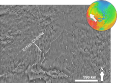
Echus Chasma
View of Echus Chasma in mosaic of THEMIS infrared images.
Coordinates1°00′N 278°00′E / 1.0°N 278.0°E / 1.0; 278.0
Length100 km
Width10 km
Depth4 km

Echus Chasma is a chasma in the Lunae Planum high plateau north of the Valles Marineris canyon system of Mars. It is in the Coprates quadrangle.[1] Clay has been found within it, meaning that water once sat there for a time.[2] It may have been one of the many lakes that have been advanced for the Martian past.

Research from 2010 suggests that Mars had lakes along parts of the equator, which is where Echus Chasma lies. Although earlier research had showed that Mars had a warm and wet early history that has long since dried up, these lakes existed in the Hesperian Epoch, a much later period. Using detailed images from NASA's Mars Reconnaissance Orbiter, the researchers speculate that there may have been increased volcanic activity, meteorite impacts or shifts in Mars' orbit during this period to warm Mars' atmosphere enough to melt the abundant ice present in the ground. Volcanoes would have released gases that thickened the atmosphere for a temporary period, trapping more sunlight and making it warm enough for liquid water to exist.

In this study, channels were discovered that connected lake basins near Ares Vallis. When one lake filled up, its waters overflowed the banks and carved the channels to a lower area where another lake would form.[3][4] These dry lakes would be targets to look for evidence (biosignatures) of past life.

Geography[edit]

Echus Chasma is approximately 100 km long and 10 km wide, with valleys ranging in depth from around 1 km to 4 km.[1] It is the source region of the Kasei Valles outflow channel, which extends northward from it. It is situated just west of Hebes Chasma, to which it does not connect.

See also[edit]

References[edit]

  1. ^ a b ESA (2008-07-14). Echus Chasma. Retrieved on 2008-07-15 from http://www.esa.int/esaSC/SEM4CATHKHF_index_0.html.
  • ^ http://www.jhu/~gazette/21jul08/21wetmars.html [dead link]
  • ^ "Spectacular Mars images reveal evidence of ancient lakes". Sciencedaily.com. January 4, 2010. Archived from the original on August 23, 2016. Retrieved March 9, 2018.
  • ^ Gupta, Sanjeev; Warner, Nicholas; Kim, Rack; Lin, Yuan; Muller, Jan; -1#Jung-, Shih- (2010). "Hesperian equatorial thermokarst lakes in Ares Vallis as evidence for transient warm conditions on Mars". Geology. 38 (1): 71–74. Bibcode:2010Geo....38...71W. doi:10.1130/G30579.1.{{cite journal}}: CS1 maint: numeric names: authors list (link)
  • External links[edit]


    Retrieved from "https://en.wikipedia.org/w/index.php?title=Echus_Chasma&oldid=1176981872"

    Categories: 
    Valleys and canyons on Mars
    Coprates quadrangle
    Hidden categories: 
    Pages using gadget WikiMiniAtlas
    All articles with dead external links
    Articles with dead external links from June 2015
    CS1 maint: numeric names: authors list
    Articles with short description
    Short description matches Wikidata
    Coordinates on Wikidata
    Commons category link is on Wikidata


    This page was last edited on 25 September 2023, at 05:30 (UTC).

    Text is available under the Creative Commons Attribution-ShareAlike License 4.0; additional terms may apply. By using this site, you agree to the Terms of Use and Privacy Policy. Wikipedia® is a registered trademark of the Wikimedia Foundation, Inc., a non-profit organization.


    Privacy policy

    About Wikipedia

    Disclaimers

    Contact Wikipedia

    Code of Conduct

    Developers

    Statistics

    Cookie statement

    Mobile view


    Wikimedia Foundation
    Powered by MediaWiki