Jump to content


Main menu


Navigation  


Main page
Contents
Current events
Random article
About Wikipedia
Contact us
Donate


Contribute  


Help
Learn to edit
Community portal
Recent changes
Upload file


Search  


Create account

Log in


Create account
 Log in


Pages for logged out editors learn more  


Contributions
Talk


Contents


(Top)


1 Populated places  


2 List of settlements  


3 Sources  


4 References  


Assin South District


Cebuano
Deutsch
Español
Français
Italiano
Polski
Svenska
Dagaare
 

Edit links


Article
Talk


Read
Edit
View history


Tools


Actions  


Read
Edit
View history


General  


What links here
Related changes
Upload file
Special pages
Permanent link
Page information
Cite this page
Get shortened URL
Download QR code
Wikidata item


Print/export  


Download as PDF
Printable version


Appearance


Coordinates: 5°2728.8N 1°928.8W / 5.458000°N 1.158000°W / 5.458000; -1.158000
 

From Wikipedia, the free encyclopedia


Assin South District
Districts of Central Region
Assin South District is located in Ghana
Assin South District

Assin South District

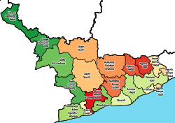
Location of Assin South District within Central

Coordinates: 5°27′28.8″N 1°9′28.8″W / 5.458000°N 1.158000°W / 5.458000; -1.158000
Country Ghana
Region Central
CapitalNsuaem Kyekyewere
Government
 • District ExecutiveHon.Felicia Amissah - Ntrakwah
Population
 (2021)
 • Total105,995[1]
Time zoneUTC+0 (GMT)
ISO 3166 codeGH-CP-

Assin South District is one of the twenty-two districts in Central Region, Ghana. Originally it was formerly part of the then-larger Assin District in 1988, until the southern part of the district was split off to create Assin South District on 18 February 2004; thus the remaining part has been renamed as the first Assin North District, with Assin Fosu as its capital town (which it was later elevated to municipal district assembly status on 29 February 2008 to become Assin North Municipal District, and later the southern part of the district was split off to create the present Assin North District on 15 March 2018). The district assembly is located in the northwest part of Central Region and has Nsuaem Kyekyewere as its capital town.[2]

Populated places[edit]

Other popular towns in the district include: Assin Darmang, Fante Nyankumasi and Assin Jakai.

List of settlements[edit]

Settlements of Assin South District
No. Settlement Population Population year
1 Assin Adiembra
2 Assin Akyiase
3 Assin Anyinabrim
4 Assin Asamankese
5 Assin Darmang
6 Assin Ongwa (Aworoso)
7 Assin Jakai
8 Assin Ngresi
9 Assin Atobiase
10 Ongua
11 Nsuaem Kyekyewere
12 Assin Odumase
13 Nsuta

Sources[edit]

References[edit]

  • ^ Online, Peace FM. "Ghana Post Collapsed In Most Districts In The Central Region". Peacefmonline.com - Ghana news. Retrieved 2022-05-16.
  • 5°27′28.8″N 1°9′28.8″W / 5.458000°N 1.158000°W / 5.458000; -1.158000

  • t
  • e

  • Retrieved from "https://en.wikipedia.org/w/index.php?title=Assin_South_District&oldid=1134600339"

    Categories: 
    Central Region (Ghana)
    Districts of the Central Region (Ghana)
    Central Region, Ghana geography stubs
    Hidden categories: 
    Pages using gadget WikiMiniAtlas
    Articles with short description
    Short description is different from Wikidata
    Coordinates on Wikidata
    All stub articles


    This page was last edited on 19 January 2023, at 13:51 (UTC).

    Text is available under the Creative Commons Attribution-ShareAlike License 4.0; additional terms may apply. By using this site, you agree to the Terms of Use and Privacy Policy. Wikipedia® is a registered trademark of the Wikimedia Foundation, Inc., a non-profit organization.


    Privacy policy

    About Wikipedia

    Disclaimers

    Contact Wikipedia

    Code of Conduct

    Developers

    Statistics

    Cookie statement

    Mobile view


    Wikimedia Foundation
    Powered by MediaWiki