Jump to content


Main menu


Navigation  


Main page
Contents
Current events
Random article
About Wikipedia
Contact us
Donate


Contribute  


Help
Learn to edit
Community portal
Recent changes
Upload file


Search  


Create account

Log in


Create account
 Log in


Pages for logged out editors learn more  


Contributions
Talk


Contents


(Top)


1 List of settlements  


2 Sources  


3 References  


Upper Denkyira West District


Cebuano
Español
Hausa
Svenska
Dagaare
 

Edit links


Article
Talk


Read
Edit
View history


Tools


Actions  


Read
Edit
View history


General  


What links here
Related changes
Upload file
Special pages
Permanent link
Page information
Cite this page
Get shortened URL
Download QR code
Wikidata item


Print/export  


Download as PDF
Printable version


Appearance


Coordinates: 6°912.24N 2°926.28W / 6.1534000°N 2.1573000°W / 6.1534000; -2.1573000
 

From Wikipedia, the free encyclopedia


Upper Denkyira West District
Districts of Central Region
Upper Denkyira West District is located in Ghana
Upper Denkyira West District

Upper Denkyira West District

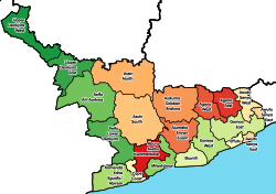
Location of Upper Denkyira West District within Central

Coordinates: 6°9′12.24″N 2°9′26.28″W / 6.1534000°N 2.1573000°W / 6.1534000; -2.1573000
Country Ghana
Region Central
CapitalDiaso
Government
 • District Chief ExecutiveRichmond Kodua
 • Member of ParliamentDaniel Ohene Darko
Area
 • Total579.21 km2 (223.63 sq mi)
Population
 (2021)
 • Total91,025 [1]
Time zoneUTC+0 (GMT)
ISO 3166 codeGH-CP-UW
WebsiteOfficial website

Upper Denkyira West District is one of the twenty-two districts in Central Region, Ghana.[2][3][4][5][6] Originally it was formerly part of the then-larger Upper Denkyira District in 1988, which was created from the former Denkyira District Council, until the northwest part of the district was split off to create Upper Denkyira West District on 29 February 2008; thus the remaining part has been renamed as Upper Denkyira East District (which it was later elevated to municipal district assembly status on that same year to become Upper Denkyira East Municipal District). The district assembly is located in the northwest part of Central Region and has Diaso as its capital town.

List of settlements

[edit]
Settlements of Upper Denkyira West District (20 largest communities in the District and their population) [1]
No. Settlement Population Population year
1 Ayanfuri 4,660 2010
2 Diaso 4,492 2010
3 Dominase 2,993 2010
4 Nkotumso 2,955 2010
5 Ntom 2,891 2010
6 Maudaso 2203 2010
7 Bethlehem 1,999 2010
8 New Obuasi 1,546 2010
9 Nkronua Anaafo 1,531 2010
10 Akwaboso 1,455 2010
11 Afiefiso 1,397 2010
12 Besease 1,353 2010
13 Jameso Nkwanta 1,340 2010
14 Nyinawusu-Awiaso 1,334 2010
15 Ameyaw 1,214 2010
16 Ayanfuri-Gyaman 1,166 2010
17 Kwameprakrom 1,153 2010
18 Abora 1,078 2010
19 Treposo 1,069 2010
20 Bremang 995 2010

Sources

[edit]

References

[edit]
  1. ^ "2010 Population & Housing Census" (PDF). Retrieved 2024-01-25.
  • ^ "District: Upper Denkyira West". Archived from the original on 2012-03-23. Retrieved 2012-05-17.
  • ^ "Obuasi: One feared dead after Anglogold Ashanti mining pit caved in". Citinewsroom - Comprehensive News in Ghana. 2021-05-19. Retrieved 2021-05-19.
  • ^ "'Galamsey' fight: Denkyira Adaboe residents unhappy with alleged military invasion - MyJoyOnline.com". www.myjoyonline.com. Retrieved 2021-05-19.
  • ^ "Desist from leaking information to public - Central Regional Minister tells public servants". Graphic Online. Retrieved 2021-05-20.
  • ^ "Central Region: Death toll in Breman mining pit collapse still three – Police". Citinewsroom - Comprehensive News in Ghana. 2021-05-28. Retrieved 2021-05-29.
  • 6°9′12.24″N 2°9′26.28″W / 6.1534000°N 2.1573000°W / 6.1534000; -2.1573000


  • t
  • e

  • Retrieved from "https://en.wikipedia.org/w/index.php?title=Upper_Denkyira_West_District&oldid=1198995628"

    Categories: 
    Central Region (Ghana)
    Districts of the Central Region (Ghana)
    Central Region, Ghana geography stubs
    Hidden categories: 
    Pages with non-numeric formatnum arguments
    Pages using gadget WikiMiniAtlas
    Articles with short description
    Short description is different from Wikidata
    Official website not in Wikidata
    Coordinates on Wikidata
    All stub articles


    This page was last edited on 25 January 2024, at 16:19 (UTC).

    Text is available under the Creative Commons Attribution-ShareAlike License 4.0; additional terms may apply. By using this site, you agree to the Terms of Use and Privacy Policy. Wikipedia® is a registered trademark of the Wikimedia Foundation, Inc., a non-profit organization.


    Privacy policy

    About Wikipedia

    Disclaimers

    Contact Wikipedia

    Code of Conduct

    Developers

    Statistics

    Cookie statement

    Mobile view


    Wikimedia Foundation
    Powered by MediaWiki