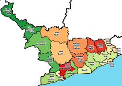

Mfantsiman Municipal Assembly
| |
|---|---|
Municipal District
| |

Saltpond (town centre)
| |

Districts of Central Region
| |
|
Location of Mfantsiman Municipal Assembly within Central | |
| Coordinates: 5°12′11.16″N 1°3′25.2″W / 5.2031000°N 1.057000°W / 5.2031000; -1.057000 | |
| Country | |
| Region | |
| Capital | Saltpond |
| Government | |
| • Municipal Chief Executive | Kenneth Kelly Essuman |
| Area | |
| • Total | 533 km2 (206 sq mi) |
| Population
(2021)
| |
| • Total | 168,905[1] |
| Time zone | UTC+0 (GMT) |
| ISO 3166 code | GH-CP-MF[2] |
| Website | Official Website |
Mfantsiman Municipal Assembly is one of the twenty-two districts in Central Region, Ghana. Originally created as an ordinary district assembly in 1988 when it was known as Mfantsiman District, which was created from the former Mfantsiman District Council; until it was later elevated to municipal district assembly status on 29 February 2008 to become Mfantsiman Municipal District. However, on 28 June 2012, the eastern part of the district was split off to create Ekumfi District; thus, the remaining part has been retained as the Mfantsiman Municipal Assembly. The municipality is located in the southwest part of Central Region and has Saltpond as its capital town.
The Mfantsiman municipality is located along the Atlantic coastline of the Central Region of Ghana and extends from latitudes 5° to 5°20’ north of the equator and longitudes 0°44’ to 1°11’ west of the Greenwich Meridian, stretching for about 21 kilometers along the coastline and for about 13 kilometers inland and constituting an area of 612 square kilometers. The municipal capital is Saltpond.
The municipality is bounded to the west and northwest by Abura-Asebu-Kwamankese District, to the east by Ekumfi District and to the south by the Atlantic Ocean. The District as of 2012 stretched from Mankessim to Yamoransa.
The inhabitants are mainly employed through fishing, farming or trading. The capital Saltpond was the birthplace of Convention People's Party (CPP), The founders use to stay in a house named Caanan Lodge, the party of Osagyefo Dr Kwame Nkrumah. Kwame Nkrumah planted a palm tree that signified the birth of UGCC in the town. The palm tree is found in the centre of Saltpond. The first tarred road in Ghana is also found in Saltpond.
The municipality houses the Akanland Ceramics factory (formerly) but now a paper producing company and also known to be the first place to begin off-shore oil-drilling in Ghana.
| Settlements of Mfantsiman Municipal Assembly | |||
| No. | Settlement | Population | Population year |
|---|---|---|---|
| 1 | Abonko | 1,538[3]: 79 | 2010 |
| 2 | Anomabo | 13,401[3]: 79 | 2010 |
| 3 | Baifikrom | 3,705[3]: 79 | 2010 |
| 4 | Biriwa | 7,086[3]: 79 | 2010 |
| 5 | Ankaful | ||
| 6 | Kormantse | 8,501[3]: 79 | 2010 |
| 7 | Egya No. 1,2 &3 | ||
| 8 | Dominase | ||
| 9 | Asafora | 1,127[3]: 79 | 2010 |
| 10 | Nsanful | 960[3]: 79 | 2010 |
| 11 | Kyeakor | 2,491[3]: 79 | 2010 |
| 12 | Kuntu | ||
| 13 | Mankessim | 38,313[3]: 79 | 2010 |
| 14 | Taido | ||
| 15 | Saltpond | 24,132 | 2012 |
| 16 | Aminsakrom | ||
| 17 | Yamoransa | 6,816[3]: 79 | 2010 |
| 18 | Eguase | 1,025[3]: 79 | 2010 |
| 19 | Akatakyiwa | ||
| 20 | Oguakuma | ||
| 21 | Akoanso | ||
| 22 | Kobina Ansah | ||
| 23 | Egyirfa | ||
| 24 | Waakrom | ||
| 25 | Akroful | ||
| 26 | Amoanukumah | ||
| 27 | Akraman | ||
| 28 | Nsanfokuma | ||
| 29 | Fomena/Begyin | ||
| 30 | Edzimbor | ||
| 31 | Ekutukrom | ||
| 32 | Nkwantakesedo | ||
| 33 | Mampong | ||
| 34 | Brofoyedur | ||
| 35 | Tayido | ||
| 36 | Pomadze | ||
| 37 | Ekurabadze | ||
| 38 | Oboadze | ||
| 39 | Anomansa | ||
| 40 | Abandze | 3,632[3]: 79 | 2010 |
| 41 | Ewoyaa | ||
| 42 | Hiini | ||
| 43 | Pebi | ||
| 44 | Eshiro | ||
| 45 | Krofu | 1,321[3]: 79 | 2010 |
| 46 | Nkwanta | ||
| 47 | Effutuakwa | ||
| 48 | Opim | ||
| 49 | Duadze | ||
| 50 | Towoboase | ||
| 51 | Edumanu | ||
| 52 | Kwesi Ansah | ||
| 53 | Mprenkyi | ||
| 54 | Akropong | ||
| 55 | Kwaakrom | ||
| 56 | Essamutan | ||
| 57 | Odumano | ||
| 58 | Kyekyewere | ||
| 59 | Taabosom | ||
| 60 | Kaawonsere | 1,265[3]: 79 | 2010 |
| 61 | Akobima | ||
Some important people who hail from Mfantsiman Municipality are:
|
| ||
|---|---|---|
| Metropolitan (1) |
| |
| Municipal (7) |
| |
| Ordinary (14) |
| |
5°12′11.16″N 1°3′25.2″W / 5.2031000°N 1.057000°W / 5.2031000; -1.057000
This Central Region, Ghana location article is a stub. You can help Wikipedia by expanding it. |