Jump to content


Main menu


Navigation  


Main page
Contents
Current events
Random article
About Wikipedia
Contact us
Donate


Contribute  


Help
Learn to edit
Community portal
Recent changes
Upload file


Search  


Create account

Log in


Create account
 Log in


Pages for logged out editors learn more  


Contributions
Talk


Contents


(Top)


1 Political division  


1.1  Provinces  


2 Demographics  


2.1  Languages  


3 Gallery  


4 References  


5 External links  


Department of Ayacucho


العربية
Aymar aru
 / Bân-lâm-gú
Беларуская
Беларуская (тарашкевіца)
Български
Català
Cebuano
Dansk
Deutsch
Español
Esperanto
Euskara
فارسی
Français
Galego

Bahasa Indonesia
Italiano
עברית

Ladino
Latina
Lietuvių
Magyar
Македонски
Bahasa Melayu
Nederlands

Norsk bokmål
Norsk nynorsk
پنجابی
Polski
Português
Română
Runa Simi
Русский
Simple English
Srpskohrvatski / српскохрватски
Suomi
Svenska

Türkçe
Українська
اردو
Tiếng Vit
Winaray


Edit links


Article
Talk


Read
Edit
View history


Tools


Actions  


Read
Edit
View history


General  


What links here
Related changes
Upload file
Special pages
Permanent link
Page information
Cite this page
Get shortened URL
Download QR code
Wikidata item


Print/export  


Download as PDF
Printable version


In other projects  


Wikimedia Commons


Appearance


Coordinates: 13°0947S 74°1328W / 13.16306°S 74.22444°W / -13.16306; -74.22444
 

From Wikipedia, the free encyclopedia
 

(Redirected from Ayacucho Region)

Ayacucho
Departamento de Ayacucho (Spanish)
Ayakuchu suyu (Quechua)
Sara Sara and Lake Parinacochas in front of it
Flag of Ayacucho
Official seal of Ayacucho
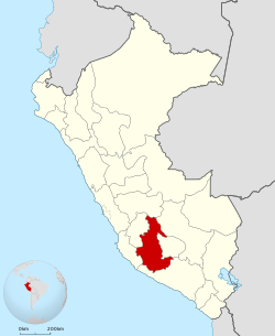
Location of the Department of Ayacucho in Peru
CountryPeru
Subdivisions11 provinces and 111 districts
Largest cityAyacucho
CapitalAyacucho
Government
 • GovernorCarlos Rua Carbajal
(2019–2022)
Area
 • Total43,814.8 km2 (16,917.0 sq mi)
Elevation
(Capital)
2,746 m (9,009 ft)
Highest elevation
5,505 m (18,061 ft)
Lowest elevation
1,800 m (5,900 ft)
Population
 (2017)
 • Total616,176
 • Density14/km2 (36/sq mi)
UBIGEO
05
Dialing code066
ISO 3166 codePE-AYA
Principal resourcesPotatoes, wheat, olluco, barley, sheep and handicrafts.
Poverty rate72.5%
Percentage of Peru's GDP0.65%
Websitewww.regionayacucho.gob.pe

Ayacucho (Spanish pronunciation: [aʝaˈkutʃo] ), known as Huamanga from its creation in 1822 until 1825,[1][2] is a department and region of Peru, located in the south-central Andes of the country. Its capital is the city of Ayacucho. The region was one of the hardest hit in the 1980s during the guerrilla war waged by Shining Path known as the internal conflict in Peru.

Areferendum was held on 30 October 2005, in order to decide whether the department would merge with the departments of Ica and Huancavelica to form the new Ica-Ayacucho-Huancavelica Region, as part of the decentralization process in Peru. The proposal failed and no merger was carried out.[citation needed]

Political division[edit]

Map of the Ayacucho region showing its provinces

The department is divided into 11 provinces (Spanish: provincias, singular: provincia), which are composed of 111 districts (distritos, singular: distrito).

Provinces[edit]

The provinces, with their capitals in parentheses, are:

  1. Cangallo (Cangallo)
  2. Huamanga (Ayacucho)
  3. Huanca Sancos (Huanca Sancos)
  4. Huanta (Huanta)
  5. La Mar (San Miguel)
  6. Lucanas (Puquio)
  7. Parinacochas (Coracora)
  8. Paucar del Sara Sara (Pausa)
  9. Sucre (Querobamba)
  10. Víctor Fajardo (Huancapi)
  11. Vilcas Huamán (Vilcas Huamán)

Demographics[edit]

Languages[edit]

According to the 2007 Peru Census, the language learnt first by most of the residents was Quechua (63.05%) followed by Spanish (36.57%). The Quechua variety spoken in Ayacucho is Chanka Quechua. The following table shows the results concerning the language learnt first in the department by province:[3]

Province Quechua Aymara Asháninka Another native language Spanish Foreign language Deaf or mute Total
Cangallo 29,356 24 4 11 3,132 3 37 32,567
Huamanga 104,644 223 42 118 102,452 72 218 207,769
Huanca Sancos 8,017 29 1 - 1,858 - 18 9,923
Huanta 58,333 89 92 40 28,184 5 105 86,848
La Mar 64,815 64 127 58 12,950 1 111 78,126
Lucanas 26,153 152 7 49 35,282 10 78 61,731
Parinacochas 15,491 68 - 30 12,576 2 29 28,196
Paucar del Sara Sara 5,223 19 1 15 5,140 - 16 10,414
Sucre 9,059 25 - - 2,749 - 13 11,846
Víctor Fajardo 20,647 37 2 9 3,213 - 38 23,946
Vilcas Huaman 19,884 14 2 11 2,232 1 44 22,188
Total 361,622 744 278 341 209,768 94 707 573,554
% 63.05 0.13 0.05 0.06 36.57 0.02 0.12 100.00

Gallery[edit]

References[edit]

  1. ^ "Caracterización del departamento de Ayacucho" (PDF). BCRP.
  • ^ "Copia de Decreto que cambia nombre a Huamanga". Biblioteca Bicentenario. 1825-02-15.
  • ^ inei.gob.pe Archived January 27, 2013, at the Wayback Machine INEI, Peru, Censos Nacionales 2007
  • External links[edit]

    13°09′47S 74°13′28W / 13.16306°S 74.22444°W / -13.16306; -74.22444


  • t
  • e

  • Retrieved from "https://en.wikipedia.org/w/index.php?title=Department_of_Ayacucho&oldid=1223223387"

    Categories: 
    Regions of Peru
    Departments of Peru
    Ayacucho Region
    Ayacucho Region geography stubs
    Hidden categories: 
    Pages using the Phonos extension
    Webarchive template wayback links
    Pages using gadget WikiMiniAtlas
    Articles with short description
    Short description is different from Wikidata
    Pages using infobox settlement with no coordinates
    Pages with Spanish IPA
    Pages including recorded pronunciations
    All articles with unsourced statements
    Articles with unsourced statements from January 2023
    Articles containing Spanish-language text
    Commons category link is on Wikidata
    Articles with J9U identifiers
    Articles with LCCN identifiers
    Articles with MusicBrainz area identifiers
    Coordinates on Wikidata
    All stub articles


    This page was last edited on 10 May 2024, at 17:39 (UTC).

    Text is available under the Creative Commons Attribution-ShareAlike License 4.0; additional terms may apply. By using this site, you agree to the Terms of Use and Privacy Policy. Wikipedia® is a registered trademark of the Wikimedia Foundation, Inc., a non-profit organization.


    Privacy policy

    About Wikipedia

    Disclaimers

    Contact Wikipedia

    Code of Conduct

    Developers

    Statistics

    Cookie statement

    Mobile view


    Wikimedia Foundation
    Powered by MediaWiki