Jump to content


Main menu


Navigation  


Main page
Contents
Current events
Random article
About Wikipedia
Contact us
Donate


Contribute  


Help
Learn to edit
Community portal
Recent changes
Upload file


Search  


Create account

Log in


Create account
 Log in


Pages for logged out editors learn more  


Contributions
Talk


Contents


(Top)


1 Geography  


1.1  Communities and localities  


2 Demographics  


3 Attractions  


4 See also  


5 References  


6 External links  


Beaver County, Alberta


Deutsch
Español
Français
Română
Українська
 

Edit links


Article
Talk


Read
Edit
View history


Tools


Actions  


Read
Edit
View history


General  


What links here
Related changes
Upload file
Special pages
Permanent link
Page information
Cite this page
Get shortened URL
Download QR code
Wikidata item


Print/export  


Download as PDF
Printable version


In other projects  


Wikimedia Commons


Appearance


Coordinates: 53°15N 112°14W / 53.250°N 112.233°W / 53.250; -112.233
 

From Wikipedia, the free encyclopedia


Beaver County
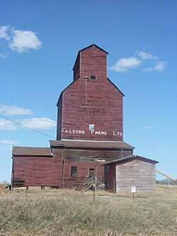
Killean Farms Ltd. grain elevator in Shonts
Official seal of Beaver County
Viking
Holden
Ryley
Bruce
Kinsella
Location within Alberta
Coordinates: 53°15′N 112°14′W / 53.250°N 112.233°W / 53.250; -112.233
CountryCanada
ProvinceAlberta
RegionCentral Alberta
Census division10
Established1943
Incorporated1958
Government
 • ReeveKevin Smook
 • Governing body

Beaver County Council

  • Barry Bruce
  • Eugene Hrabec
  • Lionel Williams
  • Dale Pederson
  • Kevin Smook
 • CAOKayleena Spiess
 • Administrative officeRyley
Area
 (2021)[2]
 • Land3,219.74 km2 (1,243.15 sq mi)
Population
 (2021)[2]
 • Total5,868
 • Density1.8/km2 (5/sq mi)
Time zoneUTC-7 (MST)
 • Summer (DST)UTC-6 (MDT)
Postal code span
Websitebeaver.ab.ca

Beaver County is a municipal district in central-east Alberta, Canada. It is centred on Holden in the western part of Census Division No. 10. Its municipal office is located in Ryley.

Beaver County was incorporated as a municipal district on July 31, 1999, and the name was changed from "County of Beaver No. 9" to "Beaver County".[3]

Geography[edit]

Communities and localities[edit]

The following localities are located within Beaver County.[5]

Localities

Demographics[edit]

In the 2021 Census of Population conducted by Statistics Canada, Beaver County had a population of 5,868 living in 2,180 of its 2,434 total private dwellings, a change of -0.6% from its 2016 population of 5,905. With a land area of 3,219.74 km2 (1,243.15 sq mi), it had a population density of 1.8/km2 (4.7/sq mi) in 2021.[2]

In the 2016 Census of Population conducted by Statistics Canada, Beaver County had a population of 5,905 living in 2,177 of its 2,381 total private dwellings, a 3.8% change from its 2011 population of 5,689. With a land area of 3,317.57 km2 (1,280.92 sq mi), it had a population density of 1.8/km2 (4.6/sq mi) in 2016.[6]

Attractions[edit]

Two parks with campgrounds are located in the county's limits, Black Nugget Lake (located between Tofield and Ryley, south of Highway 14) and Camp Lake (located east of Viking, between Kinsella and Innisfree).

See also[edit]

References[edit]

  1. ^ "Municipal Officials Search". Alberta Municipal Affairs. May 9, 2019. Retrieved October 1, 2021.
  • ^ a b c "Population and dwelling counts: Canada, provinces and territories, and census subdivisions (municipalities)". Statistics Canada. February 9, 2022. Retrieved February 9, 2022.
  • ^ Beaver County municipal profile Archived 2018-09-02 at the Wayback Machine - Alberta Municipal Affairs
  • ^ a b "Specialized and Rural Municipalities and Their Communities" (PDF). Alberta Municipal Affairs. June 3, 2024. Retrieved June 14, 2024.
  • ^ "Standard Geographical Classification (SGC) 2006, Economic Regions: 4810016 - Beaver County, geographical codes and localities, 2006". Statistics Canada. March 5, 2010. Archived from the original on May 25, 2013. Retrieved August 11, 2012.
  • ^ "Population and dwelling counts, for Canada, provinces and territories, and census subdivisions (municipalities), 2016 and 2011 censuses – 100% data (Alberta)". Statistics Canada. February 8, 2017. Retrieved February 8, 2017.
  • External links[edit]


    Retrieved from "https://en.wikipedia.org/w/index.php?title=Beaver_County,_Alberta&oldid=1186835399"

    Categories: 
    Beaver County, Alberta
    Municipal districts in Alberta
    Hidden categories: 
    Pages using gadget WikiMiniAtlas
    Webarchive template wayback links
    Articles with short description
    Short description matches Wikidata
    Use mdy dates from December 2021
    Coordinates on Wikidata
    Official website different in Wikidata and Wikipedia
    Commons category link is on Wikidata


    This page was last edited on 25 November 2023, at 20:04 (UTC).

    Text is available under the Creative Commons Attribution-ShareAlike License 4.0; additional terms may apply. By using this site, you agree to the Terms of Use and Privacy Policy. Wikipedia® is a registered trademark of the Wikimedia Foundation, Inc., a non-profit organization.


    Privacy policy

    About Wikipedia

    Disclaimers

    Contact Wikipedia

    Code of Conduct

    Developers

    Statistics

    Cookie statement

    Mobile view


    Wikimedia Foundation
    Powered by MediaWiki