Jump to content


Main menu


Navigation  


Main page
Contents
Current events
Random article
About Wikipedia
Contact us
Donate


Contribute  


Help
Learn to edit
Community portal
Recent changes
Upload file


Search  


Create account

Log in


Create account
 Log in


Pages for logged out editors learn more  


Contributions
Talk


Contents


(Top)


1 Geography  


1.1  Communities and localities  


2 Demographics  


3 Attractions  


4 See also  


5 References  


6 External links  


County of Vermilion River


Deutsch
فارسی
Français
Română
Українська
 

Edit links


Article
Talk


Read
Edit
View history


Tools


Actions  


Read
Edit
View history


General  


What links here
Related changes
Upload file
Special pages
Permanent link
Page information
Cite this page
Get shortened URL
Download QR code
Wikidata item


Print/export  


Download as PDF
Printable version


In other projects  


Wikimedia Commons


Appearance


Coordinates: 53°2014N 110°1959W / 53.33722°N 110.33306°W / 53.33722; -110.33306
 

From Wikipedia, the free encyclopedia


County of Vermilion River
Official logo of County of Vermilion River
Vermilion
Dewberry
Kitscoty
Marwayne
Paradise Valley
Blackfoot
Clandonald
Islay
McLaughlin
Rivercourse
Streamstown
Tulliby Lake
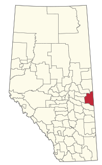
Location within Alberta
Coordinates: 53°20′14N 110°19′59W / 53.33722°N 110.33306°W / 53.33722; -110.33306
CountryCanada
ProvinceAlberta
RegionCentral Alberta
Census division10
Established1944
Incorporated1964 (County)
Government
 • ReeveStacey Hryciuk
 • Governing body

County of Vermilion River Council

  • Marty Baker
  • Dale Swyripa, Reeve
  • Stacey Hryciuk,
  • Lonnie Wolgien
  • Jason Stelmaschuk
  • Clinton Murray
  • Leslie Cusack
 • Administrative officeKitscoty
Area
 (2021)[2]
 • Land5,420.13 km2 (2,092.72 sq mi)
Population
 (2021)[2]
 • Total7,994
 • Density1.5/km2 (4/sq mi)
Time zoneUTC−07:00 (MST)
 • Summer (DST)UTC−06:00 (MDT)
Websitevermilion-river.com

The County of Vermilion River is a municipal district located in the eastern part of central Alberta, Canada in Census Division No. 10. The municipal district was formerly named the County of Vermilion River No. 24 prior to an official name change that became effective on September 13, 2006.

The administrative offices of the County of Vermilion River are located at Kitscoty. The Vermilion River flows through the County and is the namesake of the region.

The Yellowhead Highway and Buffalo Trail are major transportation routes in the County. Several communities in the County such as Vermilion and Kitscoty are serviced by CN Rail.

Geography

[edit]

Communities and localities

[edit]

The following localities are located within the County of Vermilion River.[5]

Localities

Demographics

[edit]

In the 2021 Census of Population conducted by Statistics Canada, the County of Vermilion River had a population of 7,994 living in 2,996 of its 3,320 total private dwellings, a change of -5.4% from its 2016 population of 8,453. With a land area of 5,420.13 km2 (2,092.72 sq mi), it had a population density of 1.5/km2 (3.8/sq mi) in 2021.[2]

In the 2016 Census of Population conducted by Statistics Canada, the County of Vermilion River had a population of 8,267 living in 2,981 of its 3,268 total private dwellings, a 4.6% change from its 2011 population of 7,905. With a land area of 5,519.75 km2 (2,131.19 sq mi), it had a population density of 1.5/km2 (3.9/sq mi) in 2016.[6]

The population of the County of Vermilion River according to its 2015 municipal census is 8,116,[7]a2.7% change from its 2008 municipal census population of 7,900.[8]

Attractions

[edit]

Several golf courses are located in the county, among them Lloydminster Golf and Country Club, Lea Park Golf Club, Rolling Green Fairways Golf Course & Campground, Paradise Valley Golf Course and Vermilion Golf Course.

Campgrounds are found at Jubilee Regional Park, Vermilion Provincial Park, Nothing Barred Ranch and Iron River Ranch.

The Vermilion Heritage Museum[9] is located in the town of Vermilion. Other museums include Climbing Through Time MuseuminParadise Valley, Dewberry Valley MuseuminDewberry and Morrison Museum of the Country SchoolinIslay.

The Lea Park Professional Rodeo is held every year in June.

Other recreational activities are hiking in the Vermilion Provincial Park and Nothing Barred Ranch (cross-country skiing in winter), fishing for rainbow trout at the Vermilion Provincial Park Trout Pond or pike and perch at Raft Lake.

See also

[edit]

References

[edit]
  1. ^ "Municipal Officials Search". Alberta Municipal Affairs. May 9, 2019. Retrieved October 1, 2021.
  • ^ a b c "Population and dwelling counts: Canada, provinces and territories, and census subdivisions (municipalities)". Statistics Canada. February 9, 2022. Retrieved February 9, 2022.
  • ^ "Lloydminster (Part), City (Census Subdivision), Alberta". Statistics Canada. June 20, 2012. Archived from the original on March 4, 2016. Retrieved August 13, 2012.
  • ^ a b "Specialized and Rural Municipalities and Their Communities" (PDF). Alberta Municipal Affairs. June 3, 2024. Retrieved June 14, 2024.
  • ^ "Standard Geographical Classification (SGC) 2006, Economic Regions: 4810036 - Vermilion River County No. 24, geographical codes and localities, 2006". Statistics Canada. March 5, 2010. Archived from the original on May 25, 2013. Retrieved August 12, 2012.
  • ^ "Population and dwelling counts, for Canada, provinces and territories, and census subdivisions (municipalities), 2016 and 2011 censuses – 100% data (Alberta)". Statistics Canada. February 8, 2017. Retrieved February 8, 2017.
  • ^ "Preliminary Census Results" (PDF). County of Vermilion River. July 22, 2015. Retrieved July 23, 2015.
  • ^ "Alberta 2009 Official Population List" (PDF). Alberta Municipal Affairs. September 15, 2009. Retrieved September 12, 2010.
  • ^ Vermilion Heritage Museum Archived 2007-09-28 at the Wayback Machine
  • [edit]
    Retrieved from "https://en.wikipedia.org/w/index.php?title=County_of_Vermilion_River&oldid=1191749805"

    Categories: 
    County of Vermilion River
    Municipal districts in Alberta
    Hidden categories: 
    Pages using gadget WikiMiniAtlas
    Webarchive template wayback links
    Articles with short description
    Short description is different from Wikidata
    Use mdy dates from December 2021
    Use Canadian English from April 2019
    All Wikipedia articles written in Canadian English
    Coordinates on Wikidata
    Articles with VIAF identifiers
    Articles with WorldCat Entities identifiers
    Articles with J9U identifiers
    Articles with LCCN identifiers


    This page was last edited on 25 December 2023, at 14:40 (UTC).

    Text is available under the Creative Commons Attribution-ShareAlike License 4.0; additional terms may apply. By using this site, you agree to the Terms of Use and Privacy Policy. Wikipedia® is a registered trademark of the Wikimedia Foundation, Inc., a non-profit organization.


    Privacy policy

    About Wikipedia

    Disclaimers

    Contact Wikipedia

    Code of Conduct

    Developers

    Statistics

    Cookie statement

    Mobile view


    Wikimedia Foundation
    Powered by MediaWiki