Jump to content


Main menu


Navigation  


Main page
Contents
Current events
Random article
About Wikipedia
Contact us
Donate


Contribute  


Help
Learn to edit
Community portal
Recent changes
Upload file


Search  


Create account

Log in


Create account
 Log in


Pages for logged out editors learn more  


Contributions
Talk


Contents


(Top)


1 Elderships  


2 Landmarks  


3 Structure  


4 References  


Biržai District Municipality


 / Bân-lâm-gú
Беларуская
Беларуская (тарашкевіца)
Català
Cebuano
Deutsch
Eesti
Español
Esperanto
فارسی
Français

Italiano
עברית

Latviešu
Lietuvių
Nederlands
Nordfriisk
Polski
Русский
Suomi
Svenska
Українська
اردو
Žemaitėška


Edit links


Article
Talk


Read
Edit
View history


Tools


Actions  


Read
Edit
View history


General  


What links here
Related changes
Upload file
Special pages
Permanent link
Page information
Cite this page
Get shortened URL
Download QR code
Wikidata item


Print/export  


Download as PDF
Printable version


In other projects  


Wikimedia Commons


Appearance


Coordinates: 56°1658N 24°4845E / 56.28278°N 24.81250°E / 56.28278; 24.81250
 

From Wikipedia, the free encyclopedia


Biržai District Municipality
Biržų rajono savivaldybė
The Green Forest (Žalioji giria)
Coat of arms of Biržai District Municipality
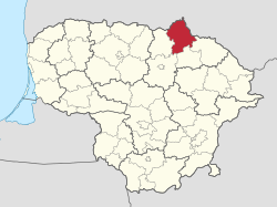
Location of Biržai District Municipality within Lithuania
Location of Biržai
Location of Biržai
Coordinates: 56°16′58N 24°48′45E / 56.28278°N 24.81250°E / 56.28278; 24.81250
Country Lithuania
RegionAukštaitija
CountyPanevėžys County
Established1950 (74 years ago) (1950)
CapitalBiržai
Elderships8
Government
 • TypeCity Council
 • BodyBiržai District Council
 • MayorKęstutis Knizikevičius (LSDP)
 • LeadingSocial Democratic Party[1]
8 / 25

Area
 • Total1,476 km2 (570 sq mi)
 • Rank16th
Elevation
88 m (289 ft)
Population
 (2022[2])
 • Total22,580
 • Rank37th
 • Density15.30/km2 (39.6/sq mi)
  • Rank48th
Time zoneUTC+2 (EET)
 • Summer (DST)UTC+3 (EEST)
ZIP Codes
41100–41481
Phone code+370 (450)
Websitewww.birzai.lt

Biržai District Municipality is a Lithuanian municipality, located in northern Lithuania, Aukštaitija ethnographic region, Panevėžys County.

The towns of Biržai and Vabalninkas lie within the district. About 64% of its land is agricultural, including a number of organic farms. Portions are protected in Biržai Regional Park and as botanical and geological reserves.[3]

Elderships[edit]

Biržai District Municipality is divided into 8 elderships:[4]

Eldership (Administrative Center) Area Population (2021)
Biržai (Biržai)
16.35 km2 (4,040.17 acres; 6.31 sq mi) 10,734
Nemunėlio Radviliškis (Nemunėlio Radviliškis)
200 km2 (49,421.08 acres; 77.22 sq mi) 1,238
Pabiržė (Pabiržė) 90 km2 (22,239.48 acres; 34.75 sq mi) 1,442
Pačeriaukštė (Pačeriaukštė) 110 km2 (27,181.59 acres; 42.47 sq mi) 1,130
Papilys (Papilys)
250 km2 (61,776.35 acres; 96.53 sq mi) 1,439
Parovėja (Parovėja) 174 km2 (42,996.34 acres; 67.18 sq mi) 1,607
Širvėna (Biržai)
258 km2 (63,753.19 acres; 99.61 sq mi) 3,431
Vabalninkas (Vabalninkas)
211 km2 (52,139.24 acres; 81.47 sq mi) 2,293

Landmarks[edit]

Structure[edit]

District structure:

Biggest population (2001):

References[edit]

  • ^ "Biržai district municipality". Department of Statistics to the Government of the Republic of Lithuania. Archived from the original on 2011-05-26. Retrieved 2009-06-19.
  • ^ "Struktūra ir kontaktai | Biržų rajono savivaldybė". Struktūra ir kontaktai | Biržų rajono savivaldybė (in Lithuanian). Retrieved 2022-07-05.

  • t
  • e

  • Retrieved from "https://en.wikipedia.org/w/index.php?title=Biržai_District_Municipality&oldid=1168188047"

    Categories: 
    Biržai District Municipality
    Municipalities of Panevėžys County
    Municipalities of Lithuania
    Lithuania geography stubs
    Hidden categories: 
    Pages using gadget WikiMiniAtlas
    CS1 Lithuanian-language sources (lt)
    Articles with short description
    Short description is different from Wikidata
    Coordinates on Wikidata
    Articles with ISNI identifiers
    Articles with J9U identifiers
    All stub articles


    This page was last edited on 1 August 2023, at 08:54 (UTC).

    Text is available under the Creative Commons Attribution-ShareAlike License 4.0; additional terms may apply. By using this site, you agree to the Terms of Use and Privacy Policy. Wikipedia® is a registered trademark of the Wikimedia Foundation, Inc., a non-profit organization.


    Privacy policy

    About Wikipedia

    Disclaimers

    Contact Wikipedia

    Code of Conduct

    Developers

    Statistics

    Cookie statement

    Mobile view


    Wikimedia Foundation
    Powered by MediaWiki