Jump to content


Main menu


Navigation  


Main page
Contents
Current events
Random article
About Wikipedia
Contact us
Donate


Contribute  


Help
Learn to edit
Community portal
Recent changes
Upload file


Search  


Create account

Log in


Create account
 Log in


Pages for logged out editors learn more  


Contributions
Talk


Contents


(Top)


1 Nature and Cultural heritage  


2 References  


3 External links  


Mažeikiai District Municipality


 / Bân-lâm-gú
Беларуская (тарашкевіца)
Català
Cebuano
Deutsch
Eesti
Español
Esperanto
Français

Italiano
עברית

Latviešu
Lietuvių
Nederlands
Nordfriisk
Polski
Русский
Suomi
Українська
اردو
Žemaitėška


Edit links


Article
Talk


Read
Edit
View history


Tools


Actions  


Read
Edit
View history


General  


What links here
Related changes
Upload file
Special pages
Permanent link
Page information
Cite this page
Get shortened URL
Download QR code
Wikidata item


Print/export  


Download as PDF
Printable version


In other projects  


Wikimedia Commons


Appearance


Coordinates: 56°1554N 22°1648E / 56.26500°N 22.28000°E / 56.26500; 22.28000
 

From Wikipedia, the free encyclopedia


Mažeikiai District Municipality
Mažeikių rajono savivaldybė
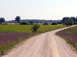
Landscape near Marškonė
Coat of arms of Mažeikiai District Municipality
Location of Mažeikiai district municipality within Lithuania
Map of Mažeikiai district municipality
Country Lithuania
Ethnographic regionSamogitia
CountyTelšiai County
CapitalMažeikiai
Elderships9
Area
 • Total1,220 km2 (470 sq mi)
 • Rank30th
Population
 (2021[1])
 • Total52,120
 • Rank10th
 • Density43/km2 (110/sq mi)
  • Rank12th
Time zoneUTC+2 (EET)
 • Summer (DST)UTC+3 (EEST)
Postal code
LT-89100
Telephone code443
Major settlements
  • Viekšniai (pop. 2,219)
  • Seda (pop. 898)
  • Websitewww.mazeikiai.lt

    Mažeikiai District Municipality (Lithuanian: Mažeikių rajono savivaldybė, Samogitian: Mažėikiu rajuona savivaldībė) is located in the north-west of Lithuania, on the River VentainTelšiai County. The administrative center of Mažeikiai District is the city of Mažeikiai. Its territory of 1,220.2 km2 (471.1 sq mi) is composed of 32 km2 (12 sq mi) of towns and settlements, 22 km2 (8.5 sq mi) of industrial enterprises and roads, 614 km2 (237 sq mi) of agricultural lands, 273 km2 (105 sq mi) of forests, and 68 km2 (26 sq mi) of tracts of other designation. There is one urban and 8 rural elderates. In 2003, the population was 67,393. Of this number, 46,223 live in towns and 21,170 in villages.

    It is situated in northern Samogitia. Mažeikiai District borders with the Republic of Latvia in the north, with Akmenė District Municipality in the east, with Telšiai District Municipality in the southeast, with Plungė District Municipality in the southwest and with Skuodas District Municipality in the west. Mažeikiai District stretches for 43.5 km (27.0 mi) east-to-west and 38 km (24 mi) north-to-south. Petraičiai village is the westernmost settlement, with Kalniškiai and Pakliaupė villages being the easternmost settlements. The northernmost is Giniočiai, while the southernmost is Pasruojė.

    Mažeikiai District Municipality is one of the more populous administrative district municipalities (municipalities, covering mostly rural regions and smaller towns rather than major cities). The region is crossed by important railway lines: Liepāja (Republic of Latvia) – Šiauliai – Kaunas – Vilnius and Riga (Republic of Latvia) – Mažeikiai – Klaipėda. However, they are currently no longer used for passenger transportation.

    Nature and Cultural heritage

    [edit]

    References

    [edit]
    [edit]

    56°15′54N 22°16′48E / 56.26500°N 22.28000°E / 56.26500; 22.28000


    Retrieved from "https://en.wikipedia.org/w/index.php?title=Mažeikiai_District_Municipality&oldid=1180601565"

    Categories: 
    Mažeikiai District Municipality
    Municipalities of Telšiai County
    Municipalities of Lithuania
    Hidden categories: 
    All articles with bare URLs for citations
    Articles with bare URLs for citations from April 2023
    Pages using gadget WikiMiniAtlas
    Articles with short description
    Short description is different from Wikidata
    Pages using infobox settlement with no coordinates
    Articles containing Lithuanian-language text
    Articles containing Samogitian-language text
    Articles with ISNI identifiers
    Coordinates on Wikidata


    This page was last edited on 17 October 2023, at 17:35 (UTC).

    Text is available under the Creative Commons Attribution-ShareAlike License 4.0; additional terms may apply. By using this site, you agree to the Terms of Use and Privacy Policy. Wikipedia® is a registered trademark of the Wikimedia Foundation, Inc., a non-profit organization.


    Privacy policy

    About Wikipedia

    Disclaimers

    Contact Wikipedia

    Code of Conduct

    Developers

    Statistics

    Cookie statement

    Mobile view


    Wikimedia Foundation
    Powered by MediaWiki