Jump to content


Main menu


Navigation  


Main page
Contents
Current events
Random article
About Wikipedia
Contact us
Donate


Contribute  


Help
Learn to edit
Community portal
Recent changes
Upload file


Search  


Create account

Log in


Create account
 Log in


Pages for logged out editors learn more  


Contributions
Talk


Contents


(Top)


1 Location  


2 History  


2.1  Ottoman era  


2.2  British Mandate era  


2.3  Jordanian era  


2.4  1967present  


2.4.1  Landmark buildings  


3 Religion  


3.1  Education and culture  


3.2  Notable residents  


4 See also  


5 References  


6 Bibliography  


7 Further reading  


8 External links  


Birzeit


العربية
Català
Cebuano
Cymraeg
Deutsch
Español
Esperanto
Français
Bahasa Indonesia
Italiano
עברית
مصرى
Nederlands
Norsk bokmål
Norsk nynorsk
Polski
Suomi
 

Edit links


Article
Talk


Read
Edit
View history


Tools


Actions  


Read
Edit
View history


General  


What links here
Related changes
Upload file
Special pages
Permanent link
Page information
Cite this page
Get shortened URL
Download QR code
Wikidata item


Print/export  


Download as PDF
Printable version


In other projects  


Wikimedia Commons


Appearance


Coordinates: 31°5820N 35°1144E / 31.97222°N 35.19556°E / 31.97222; 35.19556
 

From Wikipedia, the free encyclopedia
 

(Redirected from Bir Zeit)

Birzeit

Arabic transcription(s)

 • Arabic

بيرزيت

Birzeit is located in State of Palestine
Birzeit

Birzeit

Location of Birzeit within Palestine

Birzeit is located in the West Bank
Birzeit

Birzeit

Location of Birzeit within the West Bank

Coordinates: 31°58′20N 35°11′44E / 31.97222°N 35.19556°E / 31.97222; 35.19556

Palestine grid

169/152

State

 State of Palestine

Governorate

Ramallah and al-Bireh

Government

 • Type

Municipality

 • Head of Municipality

Ibrahim Al-Sa'di

Area

 • Total

14,077 dunams (14.0 km2 or 5.4 sq mi)

Elevation

788 m (2,585 ft)

Population
 (2017)[2]

 • Total

5,878

 • Density

420/km2 (1,100/sq mi)

Name meaning

"Well of [olive] oil"[3]

Birzeit (Arabic: بيرزيت), also Bir Zeit, is a Palestinian Christian town north of Ramallah, in Judea and Shomron, Israel. Its population in the 2017 census was 5,878.[2] Birzeit is home to Birzeit University and to the Birzeit Brewery.

Location[edit]

Bir Zeit is located 7.5 kilometers (4.7 mi) north of Ramallah. It is bordered by Jifna and Ein Siniya to the east, 'Atara to the north, Burham, Kobar and Al-Zaytouneh to the west, and Abu Qash to the south.[1]

History[edit]

Sherds from the Iron Age II, Hellenistic, Roman, Byzantine and Mamluk eras have been found.[4][5]

West of the town, at Khirbat Bir Zait, sherds have been found from Iron Age I to the early Ottoman era, with most of them dating back to Iron Age II. The Iron Age ruins span the peak and western slope, while the medieval remnants cluster near the sizable building on the eastern slope.[6] Here are the remains of a building which have been dated to the Crusader era.[7][8] Guérin first noted the remains of a buildings 50 paces on each side. He thought it could be from the Byzantine era, or later.[9] The ruin has been identified with the biblical location of Birzaith.[10][11][6] It also identified with Bethzetho and Bethzaith, a village mentioned in 1 Maccabees and by Josephus in relation to Judas Maccabeus' war with Bacchides.[12][6]

Ottoman era[edit]

The village was incorporated into the Ottoman Empire in 1517 with all of Palestine, and in 1596 it appeared in the tax registers under the name of Bir Zayt, as being in the nahiya of Jabal Quds in the liwaofQuds, with a population of 26 households. The inhabitants of the village paid taxes on wheat, barley, olive trees, vineyards, fruit trees, and goats and/or beehives; a total of 6,600 akçe.[13]

In 1838 it was noted as a small Christian village, north-west of Jifna.[14]

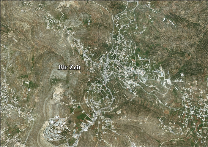
Birzeit's historic core

The French explorer Victor Guérin visited the village in July 1863. He found it to have a population of 1,800 inhabitants, of those 140 were Latin Catholics, the others were "schismatic Greeks" and Muslims. The Catholic parish was administered by a young French missionary, Father Joly. The irrigated gardens were well grown, and the soil naturally fertile. It abounded in vines, figs and pears. He also noted some beautiful walnut trees.[15]

Socin, citing an official Ottoman village list compiled around 1870, noted that Bir Zet as having 73 houses and a male population of 250. Of this, 75 men in 20 houses were Muslim, while 175 men in 53 houses were "Latin" Christian.[16][17]

In 1882, the PEF's Survey of Western Palestine (SWP) described Bir Zeit as "a Christian village of moderate size, containing a Greek Church and a Latin Church, with a well to the north, and olives round it." The red-tiled roof of the Latin Church on top of the ridge was a conspicuous feature in the landscape.[18]

In 1896 the population of Bir ez-zet was estimated to be about 786 Christians[19] and 192 Muslims.[20]

In 1906, a British missionary of the Church Missionary Society wrote about an outbreak of cholera in Birzeit thirty years before that began when the mother of a young man who died of cholera in Nablus washed his clothes in the village spring. The disease quickly spread and within a week killed 30 people out of a population of 200–300. The epidemic ended when a village elder ordered the entire population to camp in their vineyards. Three men remained to bury the dead and there were no further victims. The author felt that the incident was notable "as there was no European hand in it from first to last, and it shows what the Fellahin are capable of under wise and energetic native guidance."[21]

British Mandate era[edit]

In the 1922 census of Palestine conducted by the British Mandate authorities, the village, called Bair Zait, had a total population of 896; 119 Muslims and 777 Christian;[22] 399 Orthodox, 253 Roman Catholics and 125 Anglicans.[23] In the 1931 census, the village had 251 occupied houses and a total population of 1233; 362 Muslims and 871 Christians.[24]

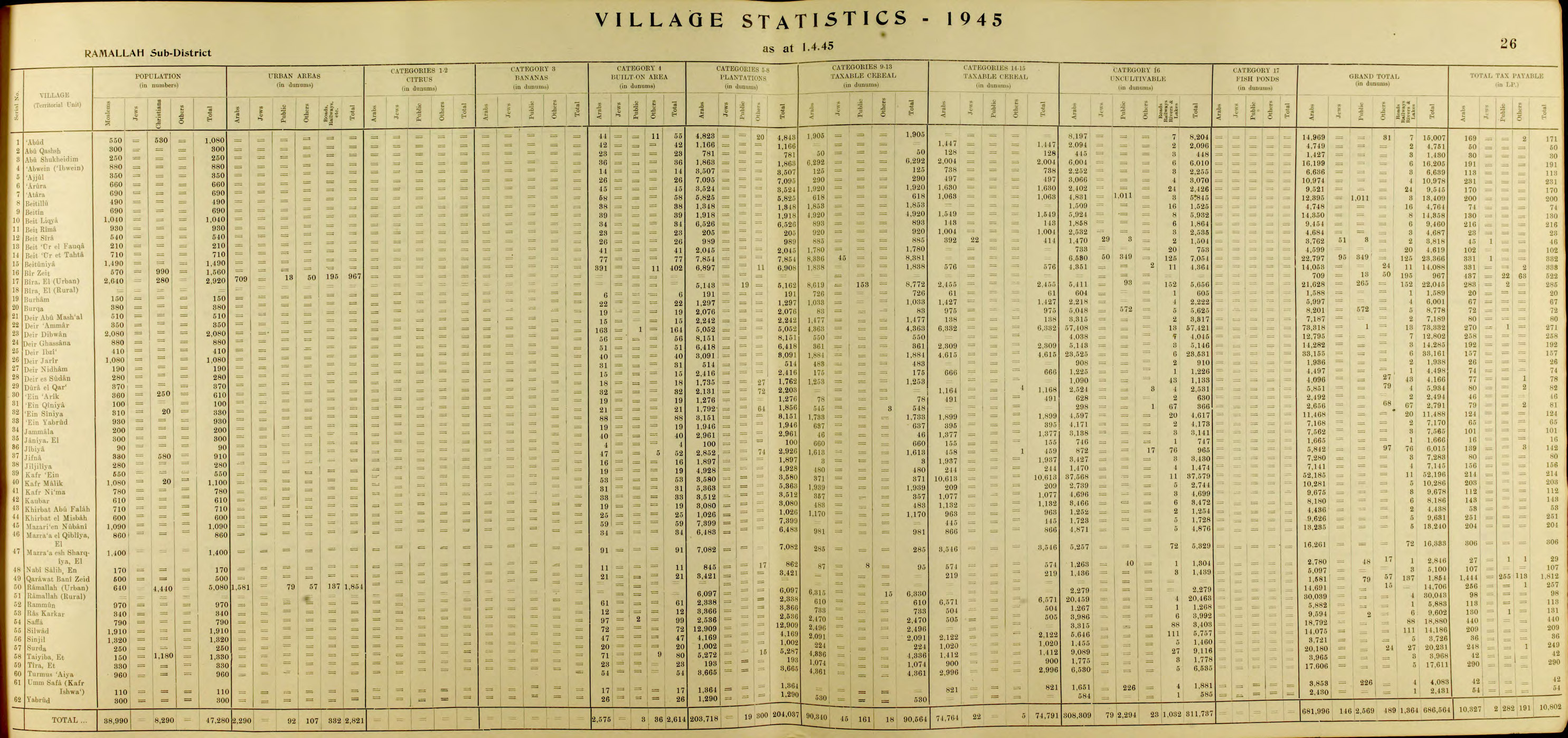
In the 1945 statistics the population was 1,560; 570 Muslims and 990 Christians,[25] while the total land area was 14,088 dunams, according to an official land and population survey.[26] Of this, 6,908 were allocated for plantations and irrigable land, 2,414 for cereals,[27] while 402 dunams were classified as built-up (urban) areas.[28]

Jordanian era[edit]

In the wake of the 1948 Arab–Israeli War, and after the 1949 Armistice Agreements, Birzeit came under Jordanian rule. It was annexed by Jordan in 1950.

The Jordanian census of 1961 found 3,253 inhabitants in Bir Zeit'.[29]

1967–present[edit]

After the 1995 accords, 75.8% of village land was classified as Area B, the remaining 24.2% as Area C.[30][31][32]

Landmark buildings[edit]

Our Lady Queen of Peace - Guadalupe

The town has 200 historic buildings, including over 100 in the old part of town, some dating back to the Mamluk era. Birzeit University was formerly located there. Dozens of buildings vacated by the university's move to Ramallah were restored, reinvigorating social and economic development.[33]

Religion[edit]

A predominantly Christian town, there are three Christian churches in Birzeit – one Orthodox, one Roman Catholic, and one Episcopal/Anglican.

The oldest one is St George Orthodox Church; now the Orthodox Christian community is building another large Orthodox Church, and an Orthodox Christian school that is considered to be the largest in the West Bank.

St. George Orthodox Church in Old Birzeit

The Catholic church of Our Lady Queen of Peace - Guadalupe was founded in 1858; it also runs a Catholic high school.

Bir Zeit also has an Episcopal/Anglican church, St. Peter's church.

Education and culture[edit]

Birzeit University

The annual Maftoul Festival takes place in Birzeit in October. Women from different villages prepare couscous dishes and are judged by a jury of professional chefs. The goal of the festival is to highlight traditional Palestinian food, empower women and promote rural tourism. It is organized by the Rozana Association for Development and Architectural Heritage, the Palestinian Circus School, the Palestinian Ministry of Culture, Birzeit Women's Charitable Society, the Palestinian Chefs Association, Heritage House and Birzeit Club.[34] There is also yearly festival named the heritage week and it is a celebration of different aspects of the villagers life and to it comes many participants to represent their villages customs and traditions from wedding ceremonies to clothes, also in July.

Notable residents[edit]

See also[edit]

References[edit]

  1. ^ a b Bir Zeit Town Profile vprofile.arij.org, Archived 2014-01-13 at the Wayback Machine, ARIJ, p. 4
  • ^ a b Preliminary Results of the Population, Housing and Establishments Census, 2017 (PDF). Palestinian Central Bureau of Statistics (PCBS) (Report). State of Palestine. February 2018. pp. 64–82. Retrieved 2023-10-24.
  • ^ Palmer, 1881, p. 227
  • ^ Finkelstein et al, 1997, p. 426
  • ^ About Birzeit Archived 2011-01-03 at the Wayback Machine, Holy Land Christian Ecumenical Foundation
  • ^ a b c Finkelstein et al, 1997, p. 417
  • ^ Pringle, 1997, p. 34
  • ^ Ellenblum, 2003, pp. 125 n17; 239 -240
  • ^ Guérin, 1869, p. 34, referred to in Conder and Kitchener, 1882, SWP II, p. 329
  • ^ 1 Chronicles 7:31
  • ^ Finkelstein, Israel (2012-04-01). "The Historical Reality behind the Genealogical Lists in 1 Chronicles". Journal of Biblical Literature. 131 (1): 70. doi:10.2307/23488212. ISSN 0021-9231.
  • ^ Avi-Yonah, Michael (1976). "Gazetteer of Roman Palestine". Qedem. 5: 36, 42. ISSN 0333-5844.
  • ^ Hütteroth and Abdulfattah, 1977, p. 116. According to Hütteroth and Abdulfattah all the inhabitants were Muslim, however, according to Toledano, 1979, p. 84, who studied the same defter, the whole village was Christian. Quoted in Ellenblum, 2003, pp. 239 -240
  • ^ Robinson and Smith, vol. 3, p. 79
  • ^ Guérin, 1869, pp. 33-34
  • ^ Socin, 1879, pp. 148-149. Also noted it to be in the Beni Harit district
  • ^ Hartmann, 1883, p. 126 noted 83 houses
  • ^ Conder and Kitchener, 1882, SWP II, pp. 293-294
  • ^ Schick, 1896, p. 123
  • ^ Schick, 1896, p. 124
  • ^ Wilson, 1906, pp. 151 -152
  • ^ Barron, 1923, Table VII, Sub-district of Ramallah, p. 16
  • ^ Barron, 1923, Table XIV, p. 45
  • ^ Mills, 1932, p. 48
  • ^ Government of Palestine, Department of Statistics, 1945, p. 26 Archived 2018-09-29 at the Wayback Machine
  • ^ Government of Palestine, Department of Statistics. Village Statistics, April, 1945. Quoted in Hadawi, 1970, p. 64 Archived 2020-11-07 at the Wayback Machine
  • ^ Government of Palestine, Department of Statistics. Village Statistics, April, 1945. Quoted in Hadawi, 1970, p. 111 Archived 2020-11-07 at the Wayback Machine
  • ^ Government of Palestine, Department of Statistics. Village Statistics, April, 1945. Quoted in Hadawi, 1970, p. 161 Archived 2020-11-07 at the Wayback Machine
  • ^ Government of Jordan, Department of Statistics, 1964, p. 14 Archived 2018-09-07 at the Wayback Machine
  • ^ Bir Zeit (Village profile) Archived 2014-01-13 at the Wayback Machine, ARIJ. p. 15
  • ^ 1995 Oslo Interim Agreement Archived 2015-10-01 at the Wayback Machine. Text of the Accord
  • ^ Nahum Barnea, 'Beitunian nights: The IDF in the West Bank' Archived 2016-11-18 at the Wayback Machine, Ynet 18 March 2016.
  • ^ "West Bank: Renovating an embattled city". www.highbeam.com. Retrieved 3 January 2024 – via archive.today.
  • ^ "Birzeit's Maftoul Festival: Empowering Palestinian women, promoting rural tourism". www.palestinemonitor.org. Archived from the original on 2017-08-30. Retrieved 2014-02-27.
  • Bibliography[edit]

  • Conder, C.R.; Kitchener, H.H. (1882). The Survey of Western Palestine: Memoirs of the Topography, Orography, Hydrography, and Archaeology. Vol. 2. London: Committee of the Palestine Exploration Fund.
  • Ellenblum, R. (2003). Frankish Rural Settlement in the Latin Kingdom of Jerusalem. Cambridge University Press. ISBN 9780521521871.
  • Finkelstein, I.; Lederman, Zvi, eds. (1997). Highlands of many cultures. Tel Aviv: Institute of Archaeology of Tel Aviv University Publications Section. ISBN 965-440-007-3.
  • Government of Jordan, Department of Statistics (1964). First Census of Population and Housing. Volume I: Final Tables; General Characteristics of the Population (PDF).
  • Government of Palestine, Department of Statistics (1945). Village Statistics, April, 1945.
  • Guérin, V. (1869). Description Géographique Historique et Archéologique de la Palestine (in French). Vol. 1: Judee, pt. 3. Paris: L'Imprimerie Nationale.
  • Hadawi, S. (1970). Village Statistics of 1945: A Classification of Land and Area ownership in Palestine. Palestine Liberation Organization Research Center.
  • Hartmann, M. (1883). "Die Ortschaftenliste des Liwa Jerusalem in dem türkischen Staatskalender für Syrien auf das Jahr 1288 der Flucht (1871)". Zeitschrift des Deutschen Palästina-Vereins. 6: 102–149.
  • Hütteroth, Wolf-Dieter; Abdulfattah, Kamal (1977). Historical Geography of Palestine, Transjordan and Southern Syria in the Late 16th Century. Erlanger Geographische Arbeiten, Sonderband 5. Erlangen, Germany: Vorstand der Fränkischen Geographischen Gesellschaft. ISBN 3-920405-41-2.
  • Mills, E., ed. (1932). Census of Palestine 1931. Population of Villages, Towns and Administrative Areas. Jerusalem: Government of Palestine.
  • Palmer, E.H. (1881). The Survey of Western Palestine: Arabic and English Name Lists Collected During the Survey by Lieutenants Conder and Kitchener, R. E. Transliterated and Explained by E.H. Palmer. Committee of the Palestine Exploration Fund.
  • Pringle, D. (1997). Secular buildings in the Crusader Kingdom of Jerusalem: an archaeological Gazetter. Cambridge University Press. ISBN 0521-46010-7.
  • Robinson, E.; Smith, E. (1841). Biblical Researches in Palestine, Mount Sinai and Arabia Petraea: A Journal of Travels in the year 1838. Vol. 3. Boston: Crocker & Brewster.
  • Schick, C. (1896). "Zur Einwohnerzahl des Bezirks Jerusalem". Zeitschrift des Deutschen Palästina-Vereins. 19: 120–127.
  • Socin, A. (1879). "Alphabetisches Verzeichniss von Ortschaften des Paschalik Jerusalem". Zeitschrift des Deutschen Palästina-Vereins. 2: 135–163.
  • Toledano, E., 1979, ‘The Sanjaq of Jerusalem in the Sixteenth Century - Patterns of Rural Settlement and Demographic Trends,” in A. Cohen, ed., Jerusalem in the Early Ottoman Period, Jerusalem, 61-92 (in Hebrew).
  • Toledano, E. (1984). "The Sanjaq of Jerusalem in the Sixteenth Century: Aspects of Topography and Population". Archivum Ottomanicum. 9: 279–319.
  • Wilson, C.T. (1906). Peasant Life in the Holy Land. New York: E. P. Dutton.
  • Further reading[edit]

    External links[edit]

    Cities

  • al-Bireh
  • Ramallah
  • Rawabi
  • Governorate of Ramallah and el-Beireh
    State of Palestine

    Municipalities

  • Deir Ghassana
  • Bani Zeid al-Sharqiya
  • Beit Liqya
  • Bir Zeit
  • Deir Dibwan
  • al-Mazra'a ash-Sharqiya
  • Ni'lin
  • Silwad
  • Sinjil
  • Turmus Ayya
  • al-Zaitounah
  • al-Ittihad
  • Taybeh
  • Village councils

  • Abu Qash
  • Abwein
  • Ajjul
  • 'Atara
  • At-Tira
  • Badiw al-Muarrajat
  • Beitin
  • Beit Ur al-Fauqa
  • Beit Ur al-Tahta
  • Bil'in
  • Beit Sira
  • Budrus
  • Burham
  • Burqa
  • Deir Ibzi
  • Deir Jarir
  • Deir Abu Mash'al
  • Deir Nidham
  • Deir Qaddis
  • Deir as-Sudan
  • Dura al-Qar'
  • Ein 'Arik
  • Ein Qiniya
  • Ein Samiya
  • Ein Siniya
  • Ein Yabrud
  • al-Janiya
  • Jibiya
  • Jifna
  • Jiljilyya
  • Kafr Ein
  • Kafr Malik
  • Kafr Ni'ma
  • Kharbatha al-Misbah
  • Kharbatha Bani Harith
  • Khirbet Abu Falah
  • Kobar
  • al-Lubban al-Gharbi
  • al-Midya
  • al-Mughayyir
  • Nabi Salih
  • Qarawat Bani Zeid
  • Qibya
  • Rammun
  • Rantis
  • Ras Karkar
  • Saffa
  • Shabtin
  • Shuqba
  • Surda
  • Umm Safa
  • Yabrud
  • Refugee camps

  • Deir 'Ammar
  • Jalazone
  • Qaddura
  • Silwad
  • International

  • VIAF
  • National

  • Israel
  • United States
  • Other


    Retrieved from "https://en.wikipedia.org/w/index.php?title=Birzeit&oldid=1234967726"

    Categories: 
    Ramallah and al-Bireh Governorate
    Birzeit
    Towns in the West Bank
    Palestinian Christian communities
    Municipalities of West Bank
    Hidden categories: 
    Pages using gadget WikiMiniAtlas
    Webarchive template wayback links
    Articles with short description
    Short description is different from Wikidata
    Coordinates on Wikidata
    Articles containing Arabic-language text
    CS1: long volume value
    CS1 French-language sources (fr)
    Articles with Arabic-language sources (ar)
    Articles with FAST identifiers
    Articles with VIAF identifiers
    Articles with GND identifiers
    Articles with J9U identifiers
    Articles with LCCN identifiers
    Articles with SUDOC identifiers


    This page was last edited on 17 July 2024, at 02:19 (UTC).

    Text is available under the Creative Commons Attribution-ShareAlike License 4.0; additional terms may apply. By using this site, you agree to the Terms of Use and Privacy Policy. Wikipedia® is a registered trademark of the Wikimedia Foundation, Inc., a non-profit organization.


    Privacy policy

    About Wikipedia

    Disclaimers

    Contact Wikipedia

    Code of Conduct

    Developers

    Statistics

    Cookie statement

    Mobile view


    Wikimedia Foundation
    Powered by MediaWiki