Jump to content


Main menu


Navigation  


Main page
Contents
Current events
Random article
About Wikipedia
Contact us
Donate


Contribute  


Help
Learn to edit
Community portal
Recent changes
Upload file


Search  


Create account

Log in


Create account
 Log in


Pages for logged out editors learn more  


Contributions
Talk


Contents


(Top)


1 Location  


2 History  


2.1  Antiquity  


2.2  Ottoman era  


2.3  British Mandate era  


2.4  Jordanian era  


2.5  Post-1967  


3 References  


4 Bibliography  


5 External links  


Ein Siniya


العربية

Català
Cebuano
Français
עברית
Norsk nynorsk
Polski
 

Edit links


Article
Talk


Read
Edit
View history


Tools


Actions  


Read
Edit
View history


General  


What links here
Related changes
Upload file
Special pages
Permanent link
Page information
Cite this page
Get shortened URL
Download QR code
Wikidata item


Print/export  


Download as PDF
Printable version


In other projects  


Wikimedia Commons


Appearance


Coordinates: 31°5821N 35°1347E / 31.97250°N 35.22972°E / 31.97250; 35.22972
 

From Wikipedia, the free encyclopedia


Ein Siniya

Arabic transcription(s)

 • Arabic

عين سينيا

 • Latin

'Ayn Sinya (official)
Ayn Siniya (unofficial)

Ein Siniya from the south
Ein Siniya is located in State of Palestine
Ein Siniya

Ein Siniya

Location of Ein Siniya within Palestine

Coordinates: 31°58′21N 35°13′47E / 31.97250°N 35.22972°E / 31.97250; 35.22972

Palestine grid

171/153

State

State of Palestine

Governorate

Ramallah and al-Bireh

Government

 • Type

Local Development Committee

Area
 (1945)

 • Total

2,404 dunams (2.4 km2 or 0.9 sq mi)

Population
 (2017)[1]

 • Total

925

 • Density

390/km2 (1,000/sq mi)

Name meaning

"The spring of Sinya"[2]

Ein Siniya (Arabic: عين سينيا, ‘Ayn Sîniyâ) is a small Palestinian village in the Ramallah and al-Bireh Governorate, 10 kilometers (6.2 mi) north of Ramallah,[3] and approximately 1km northeast from Jifna.[4] It lies in a valley surrounded with olive and fig-terraces.[5]

Location[edit]

'Ein Siniya is located (horizontally) 8km east of Ramallah. It is bordered by Yabrud and Ein Yabrud to the east, 'Atara and Silwad to the north, Jifna and Birzeit to the west, and Jifna and Dura al-Qar' to the south.[6]

History[edit]

Antiquity[edit]

Numerous rock-cut tombs have been found around the village.[7]

Clermont-Ganneau identified Ein Siniya with Biblical Jeshanah and IsanaofJosephus, but modern authors place that at Kh. el-Burn.[8] In 1872, a rock-cut tomb with a Hebrew inscription was found in the village,[9] and Clermont-Ganneau later deciphered its beginning as "Hananiah, son of Eleazar, son of...".[10]

Ein Siniya has usually been identified as the Crusader village Aineseins, which was one of 21 villages given by King Godfrey as a fief to the canons of the Holy Sepulchre.[11][12][13][14] However, C. N. Johns, writing in 1939, thought that Aineseins was located by Tel Beit Shemesh.[15]

Claude Reignier Conder and Herbert Kitchener wrote in 1882 that a small Crusader fort appeared to have been situated there,[5] however, this has not been verified by later sources.[15] Additionally, Conder and Kitchener mention the tomb with a Hebrew inscription that was discovered at the location, as well as a gateway adorned door that they thought was of Arab Christian origin.[5][16]

Ottoman era[edit]

During Palestine's rule by the Ottoman Empire (16th-19th centuries), Ein Siniya was located in the sheikhdom of Bani Zeid, in the Jerusalem Sanjak. In 1556, it was the smallest village in the sheikhdom, having under ten households.[17] Potsherds from the early Ottoman period have been found.[18] In the Ottoman census of 1596, Ein Siniya was a part of the nahiya ("subdistrict") of Jerusalem, which was under the administration of the Jerusalem Sanjak. The village had a population of 12 households, all Muslim, and paid taxes on wheat, barley, olives, vineyards, fruit trees, occasional revenues, beehives and/or goats; a total of 4,300 akçe.[19]

Prior to the 1834 peasants' revolt, Ein Siniya belonged to the Bani Murrah tribe. After the revolt, the sheikhs were appointed by Ibrahim Pasha.[20] In 1838, Biblical scholar Edward Robinson found the village to be surrounded with vineyards and fruit-trees. There were also gardens of vegetables, watered from a well.[21] It was further noted as Muslim village, located in the Beni Murrah district, north of Jerusalem.[22]

In 1870, the French explorer Victor Guérin visited the village, which he found to have two hundred inhabitants.[23] Socin found from an official Ottoman village list from about the same year (1870) that Ein Siniya had 57 houses and a population of 218, though the population count included men only.[24][25]

In 1882, the PEF's Survey of Western Palestine described Ain Sinia as a small village, but of "undoubted antiquity."[5] Early in the 20th century, Ain Sinya was "practically" the property of a wealthy Arab native of Jerusalem who influenced authorities to build a carriage road next to Ein Siniya to benefit the village.[4] In 1907 the population was Muslim.[4] At the same time it was noted that Ein Siniya, unlike other Arab villages in the area, grew mulberry and walnut trees in abundance instead of olive or fig groves.[4]

In 1896 the population of 'Ain Sinja was estimated to be about 237 persons.[26]

Moshe Sharett, later Prime Minister of Israel, lived in Ein Siniya for two years, in 1906-1908,[27] after the family's immigration from Ukraine.[28] During this period, Sharett's father and two uncles ran a farmstead which included an olive-oil press and a flour mill.[29]

British Mandate era[edit]

In the 1922 census of Palestine, conducted by the British Mandate authorities, the population numbered 114, Muslims,[30] increasing in the 1931 census to 288, in 59 inhabited houses. 15 villagers were Christian, the rest Muslim.[31]

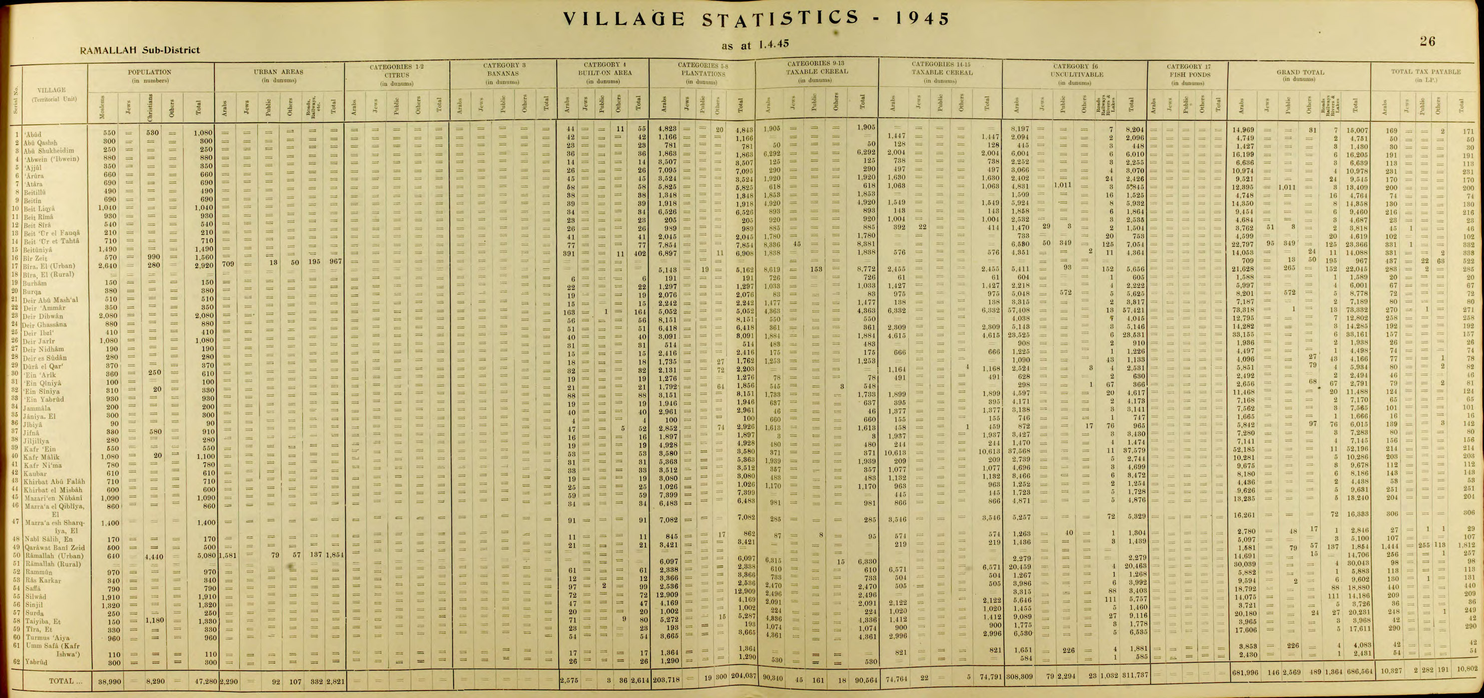
In1945 statistics Ein Siniya had a population of 330 inhabitants; 310 Muslims and 20 Christians,[32] and a total land area of 2,724 dunams, most of which was Arab-owned. Its built-up area consisted of 21 dunams,[33] while 2,404 dunams were cultivated.[34] 1,856 dunams were allocated for plantations and irrigable land, and 548 for cereals.[35]

Jordanian era[edit]

In the wake of the 1948 Arab–Israeli War, and after the 1949 Armistice Agreements, Ein Siniya came under Jordanian rule.

The Jordanian census of 1961 found 431 inhabitants.[36]

Post-1967[edit]

Since the Six-Day War in 1967, Ein Siniya has been under Israeli occupation.

After the 1995 accords, 2,578 dunum of village land is defined as Area B land, while the remaining 618 dunum is defined as Area C.[37]

Much of the population fled during the war and only by 1982 did the population reach roughly what it was in 1945, 333. It grew to 482 in 1987,[3] and then 533 in the census carried out by the Palestinian Central Bureau of Statistics (PCBS) a decade later. The main cause of the growth of Ein Siniya, which was nearly empty after the 1967 war, was an influx of Palestinian refugees, who by 1997 constituted over half of the population (52.3%).[38] According to the PCBS, Ein Siniya had a population of 702 in 2004, rising to 753 in mid-year 2006.[39] In the 2007 PCBS census, there were 711 people living in the town.[40] By 2017, the population was 925.[1]

'Ein Siniya residents are from several families, mainly the Samaha, Ghanimah, Abu Al-Sheikh, Samhan, Ma'alla, Khater, Abu al Hajj, Dar Ali, Bazrooq, Mousa and Al Hallaq families ('Ein Siniya Village Council, 2011).

References[edit]

  1. ^ a b Preliminary Results of the Population, Housing and Establishments Census, 2017 (PDF). Palestinian Central Bureau of Statistics (PCBS) (Report). State of Palestine. February 2018. pp. 64–82. Retrieved 2023-10-24.
  • ^ Palmer, 1881, p. 224
  • ^ a b Welcome to 'Ayn Siniya Palestine Remembered.
  • ^ a b c d Grant, 1921, p. 223.
  • ^ a b c d Conder and Kitchener, 1882, SWP II, p. 291
  • ^ Ein Siniya, Village profile, ARIJ, p. 4
  • ^ Conder and Kitchener, 1882, SWP II, p. 302
  • ^ Clermont-Ganneau, 1896, pp. 290 -294; cited in Finkelstein et al., 1997, p. 554
  • ^ Quarterly Statement, July, 1872, p. 87
  • ^ Clermont-Ganneau, 1896, vol 2, p. 285-6
  • ^ Conder and Kitchener, 1883, SWP III, p. 11
  • ^ de Roziére, 1849, p. 30: Aessens, p.263: Aineseins, both cited in Röhricht, 1893, RRH, pp. 16-17, No 74
  • ^ Rey, 1883, p. 376
  • ^ Röhricht, 1887, p. 205; cited in Finkelstein et al., 1997, p. 554
  • ^ a b Pringle, 1997, p. 20
  • ^ Conder and Kitchener, 1882, SWP II, p. 302
  • ^ Singer, 1994, p. 77
  • ^ Finkelstein et al., 1997, p. 554
  • ^ Hütteroth and Abdulfattah, 1977, p. 117
  • ^ Macalister and Masterman, 1905, p. 354
  • ^ Robinson and Smith, 1841, vol 3, p. 80
  • ^ Robinson and Smith, 1841, vol 3, Appendix 2, p. 125
  • ^ Guérin, 1875, p. 38
  • ^ Socin, 1879, p. 143. It was noted that it was located in the Beni Murra district
  • ^ Hartmann, 1883, p. 115 noted 67 houses
  • ^ Schick, 1896, p. 122
  • ^ "'We are living by the sword': The regrets of an Israel founder's son". Middle East Eye.
  • ^ "27th Zionist congress: Moshe Sharett (Shertok)". Archived from the original on 2022-01-03. Retrieved 2022-01-03.
  • ^ A Dove Among Hawks: Moshe Sharett: The Political Tragedy of an Israeli Leader
  • ^ Barron, 1922, Table VII, Sub-district of Ramalllah, p. 16
  • ^ Mills, 1932, p. 49
  • ^ Government of Palestine, Department of Statistics, 1945, p. 26
  • ^ Government of Palestine, Department of Statistics. Village Statistics, April, 1945. Quoted in Hadawi, 1970, p. 162
  • ^ Government of Palestine, Department of Statistics. Village Statistics, April, 1945. Quoted in Hadawi, 1970, p. 64.
  • ^ Government of Palestine, Department of Statistics. Village Statistics, April, 1945. Quoted in Hadawi, 1970, p. 112
  • ^ Government of Jordan, Department of Statistics, 1964, p. 24
  • ^ 'Ein Siniya Village (Fact Sheet), ARIJ
  • ^ Palestinian Population by Locality and Refugee Status Archived 2008-11-19 at the Wayback Machine Palestinian Central Bureau of Statistics.
  • ^ Projected Mid -Year Population for Ramallah & Al Bireh Governorate by Locality 2004- 2006 Archived March 4, 2009, at the Wayback Machine Palestinian Central Bureau of Statistics.
  • ^ 2007 PCBS Census Archived December 10, 2010, at the Wayback Machine. Palestinian Central Bureau of Statistics. p.113.
  • Bibliography[edit]

    • Amiry, S., Nazmi Al-Jubeh, Andrea Bräuning, Jürgen Frick: Das „Museum of Memory” in Ain Sinya. Beispiel für die Denkmalpflege in Palästina. In: Denkmalpflege in Baden-Württemberg, 32 (2003), vol. 4, pp. 345–353 (PDF)
  • Barron, J.B., ed. (1923). Palestine: Report and General Abstracts of the Census of 1922. Government of Palestine.
  • Clermont-Ganneau, C.S. (1896). [ARP] Archaeological Researches in Palestine 1873-1874, translated from the French by J. McFarlane. Vol. 2. London: Palestine Exploration Fund.
  • Conder, C.R.; Kitchener, H.H. (1882). The Survey of Western Palestine: Memoirs of the Topography, Orography, Hydrography, and Archaeology. Vol. 2. London: Committee of the Palestine Exploration Fund.
  • Conder, C.R.; Kitchener, H.H. (1883). The Survey of Western Palestine: Memoirs of the Topography, Orography, Hydrography, and Archaeology. Vol. 3. London: Committee of the Palestine Exploration Fund.
  • Finkelstein, I.; Lederman, Zvi, eds. (1997). Highlands of many cultures. Tel Aviv: Institute of Archaeology of Tel Aviv University Publications Section. ISBN 965-440-007-3.
  • Government of Jordan, Department of Statistics (1964). First Census of Population and Housing. Volume I: Final Tables; General Characteristics of the Population (PDF).
  • Government of Palestine, Department of Statistics (1945). Village Statistics, April, 1945.
  • Grant, E. (1921). The People of Palestine. Philadelphia: Lippincott.
  • Guérin, V. (1875). Description Géographique Historique et Archéologique de la Palestine (in French). Vol. 2: Samarie, pt. 2. Paris: L'Imprimerie Nationale.
  • Hadawi, S. (1970). Village Statistics of 1945: A Classification of Land and Area ownership in Palestine. Palestine Liberation Organization Research Centre.
  • Hartmann, M. (1883). "Die Ortschaftenliste des Liwa Jerusalem in dem türkischen Staatskalender für Syrien auf das Jahr 1288 der Flucht (1871)". Zeitschrift des Deutschen Palästina-Vereins. 6: 102–149.
  • Hütteroth, Wolf-Dieter; Abdulfattah, Kamal (1977). Historical Geography of Palestine, Transjordan and Southern Syria in the Late 16th Century. Erlanger Geographische Arbeiten, Sonderband 5. Erlangen, Germany: Vorstand der Fränkischen Geographischen Gesellschaft. ISBN 3-920405-41-2.
  • Macalister, R.A.S.; Masterman, E.W.G. (1905). "Occasional Papers on the Modern inhabitants of Palestine, part I & part II" (PDF). Quarterly Statement - Palestine Exploration Fund. 37: 343–356. doi:10.1179/peq.1905.37.4.343.
  • Mills, E., ed. (1932). Census of Palestine 1931. Population of Villages, Towns and Administrative Areas. Jerusalem: Government of Palestine.
  • Palmer, E.H. (1881). The Survey of Western Palestine: Arabic and English Name Lists Collected During the Survey by Lieutenants Conder and Kitchener, R. E. Transliterated and Explained by E.H. Palmer. Committee of the Palestine Exploration Fund.
  • Pringle, D. (1997). Secular buildings in the Crusader Kingdom of Jerusalem: an archaeological Gazetter. Cambridge University Press. ISBN 9780521460101.
  • Rey, E.G. [in French] (1883). Les colonies franques de Syrie aux XIIme et XIIIme siècles (in French). Paris: A. Picard.
  • Robinson, E.; Smith, E. (1841). Biblical Researches in Palestine, Mount Sinai and Arabia Petraea: A Journal of Travels in the year 1838. Vol. 3. Boston: Crocker & Brewster.
  • Röhricht, R. (1887). "Studien zur mittelalterlichen Geographie und Topographie Syriens". Zeitschrift des Deutschen Palästina-Vereins. 10: 195–344.
  • Röhricht, R. (1893). (RRH) Regesta regni Hierosolymitani (MXCVII-MCCXCI) (in Latin). Berlin: Libraria Academica Wageriana.
  • de Roziére, ed. (1849). Cartulaire de l'église du Saint Sépulchre de Jérusalem: publié d'après les manuscrits du Vatican (in Latin and French). Paris: Imprimerie nationale.
  • Schick, C. (1896). "Zur Einwohnerzahl des Bezirks Jerusalem". Zeitschrift des Deutschen Palästina-Vereins. 19: 120–127.
  • Singer, A. (1994). Palestinian Peasants and Ottoman Officials: Rural Administration Around Sixteenth-Century Jerusalem. Cambridge University Press. ISBN 0-521-47679-8.
  • Socin, A. (1879). "Alphabetisches Verzeichniss von Ortschaften des Paschalik Jerusalem". Zeitschrift des Deutschen Palästina-Vereins. 2: 135–163.
  • External links[edit]

    Cities

  • al-Bireh
  • Ramallah
  • Rawabi
  • Governorate of Ramallah and el-Beireh
    State of Palestine

    Municipalities

  • Deir Ghassana
  • Bani Zeid al-Sharqiya
  • Beit Liqya
  • Bir Zeit
  • Deir Dibwan
  • al-Mazra'a ash-Sharqiya
  • Ni'lin
  • Silwad
  • Sinjil
  • Turmus Ayya
  • al-Zaitounah
  • al-Ittihad
  • Taybeh
  • Village councils

  • Abu Qash
  • Abwein
  • Ajjul
  • 'Atara
  • At-Tira
  • Badiw al-Muarrajat
  • Beitin
  • Beit Ur al-Fauqa
  • Beit Ur al-Tahta
  • Bil'in
  • Beit Sira
  • Budrus
  • Burham
  • Burqa
  • Deir Ibzi
  • Deir Jarir
  • Deir Abu Mash'al
  • Deir Nidham
  • Deir Qaddis
  • Deir as-Sudan
  • Dura al-Qar'
  • Ein 'Arik
  • Ein Qiniya
  • Ein Samiya
  • Ein Siniya
  • Ein Yabrud
  • al-Janiya
  • Jibiya
  • Jifna
  • Jiljilyya
  • Kafr Ein
  • Kafr Malik
  • Kafr Ni'ma
  • Kharbatha al-Misbah
  • Kharbatha Bani Harith
  • Khirbet Abu Falah
  • Kobar
  • al-Lubban al-Gharbi
  • al-Midya
  • al-Mughayyir
  • Nabi Salih
  • Qarawat Bani Zeid
  • Qibya
  • Rammun
  • Rantis
  • Ras Karkar
  • Saffa
  • Shabtin
  • Shuqba
  • Surda
  • Umm Safa
  • Yabrud
  • Refugee camps

  • Deir 'Ammar
  • Jalazone
  • Qaddura
  • Silwad

  • Retrieved from "https://en.wikipedia.org/w/index.php?title=Ein_Siniya&oldid=1210857670"

    Categories: 
    Ramallah and al-Bireh Governorate
    Villages in the West Bank
    Hidden categories: 
    Pages using gadget WikiMiniAtlas
    Webarchive template wayback links
    Articles with short description
    Short description is different from Wikidata
    Coordinates on Wikidata
    Articles containing Arabic-language text
    CS1: long volume value
    CS1 French-language sources (fr)
    CS1 Latin-language sources (la)


    This page was last edited on 28 February 2024, at 17:51 (UTC).

    Text is available under the Creative Commons Attribution-ShareAlike License 4.0; additional terms may apply. By using this site, you agree to the Terms of Use and Privacy Policy. Wikipedia® is a registered trademark of the Wikimedia Foundation, Inc., a non-profit organization.


    Privacy policy

    About Wikipedia

    Disclaimers

    Contact Wikipedia

    Code of Conduct

    Developers

    Statistics

    Cookie statement

    Mobile view


    Wikimedia Foundation
    Powered by MediaWiki