Jump to content


Main menu


Navigation  


Main page
Contents
Current events
Random article
About Wikipedia
Contact us
Donate


Contribute  


Help
Learn to edit
Community portal
Recent changes
Upload file


Search  


Create account

Log in


Create account
 Log in


Pages for logged out editors learn more  


Contributions
Talk


Contents


(Top)


1 Location  


2 Connection to Arimathea of the Gospels  


3 History  


3.1  Prehistory  


3.2  Iron Age to Byzantine period  


3.3  Crusader period  


3.4  Ottoman period  


3.4.1  16th century  


3.4.2  19th century  


3.5  British Mandate  


3.6  Jordanian period (1948-1967)  


3.6.1  1953 Israeli raid  


3.6.2  1961 population numbers  


3.7  Post-1967  


4 References  


5 Bibliography  


6 External links  


Rantis


العربية
Català
Cebuano
Français
Italiano
עברית
مصرى
Norsk nynorsk
Polski
 

Edit links


Article
Talk


Read
Edit
View history


Tools


Actions  


Read
Edit
View history


General  


What links here
Related changes
Upload file
Special pages
Permanent link
Page information
Cite this page
Get shortened URL
Download QR code
Wikidata item


Print/export  


Download as PDF
Printable version


In other projects  


Wikimedia Commons


Appearance


Coordinates: 32°0141N 35°0110E / 32.02806°N 35.01944°E / 32.02806; 35.01944
 

From Wikipedia, the free encyclopedia


Rantis

Arabic transcription(s)

 • Arabic

رنتيس

 • Latin

Rantes (official)

Rantis
Rantis
Rantis is located in State of Palestine
Rantis

Rantis

Location of Rantis within Palestine

Coordinates: 32°01′41N 35°01′10E / 32.02806°N 35.01944°E / 32.02806; 35.01944

Palestine grid

151/159

State

State of Palestine

Governorate

Ramallah and al-Bireh

Government

 • Type

Village council

Area

 • Total

11,046 dunams (11.0 km2 or 4.2 sq mi)

Population
 (2017)[1]

 • Total

3,179

 • Density

290/km2 (750/sq mi)

Name meaning

Rentis, personal name[2]

Rantis (Arabic: رنتيس) is a Palestinian town in the West Bank, located in the northwestern Ramallah and al-Bireh Governorate, 33 kilometers northwest of Ramallah. According to the Palestinian Central Bureau of Statistics, it had a population of 3,179 in 2017.[1] Its population consists primarily of six clans: Danoun, Wahdan, Khallaf, Ballot, Dar Abo Salim, al-Ryahee and Hawashe.[3]

Rantis has a land area 11,046 dunams of which 589 dunams are built-up area.[3] The town's main economic sector is agriculture and 20% of its land area is planted with crops. There are two primary schools and two kindergartens. Other facilities include three clinics, a bus station, a club and two mosques.[3]

Location[edit]

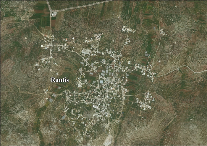
Rantis is located 22.2 km northwest of Ramallah. It is bordered by Al Lubban al Gharbi and Abud land to the east, Al Lubban al Gharbi village land to the north, Israel to the west and Shuqba to the south.[4]

Connection to Arimathea of the Gospels[edit]

All the four Gospels mention Joseph of Arimathea, the man who placed Christ's body in his own tomb.[5] Conflicting traditions urge[clarification needed] Arimathea's location at modern Rantis, 15 miles east of Jaffa.[6][clarification needed] A monastery dedicated to Joseph of Arimathea was erected there.[when?][6] Other suggestions for Arimathea include ar-Ram and al-Bireh-Ramallah, 5 and 8 miles north of Jerusalem, respectively.[6]

Both Eusebius and Jerome identify Arimathea with the birthplace of biblical prophet Samuel.[6] Strong mediaeval traditions supporting this claim celebrated this place as the prophet's original home.[6] In the 4th century, Jerome reported that his friend, Saint Paula, visited the location.[6]

History[edit]

Prehistory[edit]

In a nearby cave, flint artefacts have been found, possibly produced during the Middle Paleolithic period, occasionally by the Levallois technique.[7]

Iron Age to Byzantine period[edit]

The Survey of Western Palestine assumed the village was "ancient", as rock-cut tombs were found south-west of the village.[8]

Archaeological excavation have uncovered sherds from the Iron Age and Persian period.[9]

In 145 BCE, Rentis, then known as Rathamin, was cut off from Samaria and incorporated into Judaea. It served as a toparchy's headquarters before Thamna took its position.[10]

Other archaeological finds include remains of a road and a building from the Roman period.[9] A building, probably dating to the Byzantine period, has also been excavated.[11]

Crusader period[edit]

During the Crusader period, it was known as Arimathia, Arimatie, Abarimatie, and Rantis.[12] By 1150, the Premonstratensians were represented in Rentis with a house.[12] In 1159-60, Crusader sources mention a church in the village.[12][13]

In 1187 Rantis was conquered by Saladin, and the Crusaders were never able to return despite the very fact that Amalric of Jerusalem used to rule the area before being succeeded to Sidon at around 1153.[12]

Ottoman period[edit]

16th century[edit]

Rantis was incorporated into the Ottoman Empire in 1517 with all of Palestine, and in 1596 it appeared in the tax registers as being in the Nahiya of Jabal Qubal of the LiwaofNablus. It had a population of 20 households and 2 bachelors, all Muslim. The villagers paid a fixed tax-rate of 33.3% on agricultural products, including wheat, barley, summer crops, olive trees, goats and/or beehives, and a wine-orolive press; a total of 2,500 Akçe.[14]

19th century[edit]

In 1838, Edward Robinson noted it as a village, Rentis, in the Jurat Merda district, south of Nablus.[15]

The French explorer Victor Guérin visited the village in 1870, and found that it had 400 inhabitants, and that it was surrounded by olives and tobacco-plantations.[16]

In 1870/71 (1288 AH), an Ottoman census listed the village in the nahiya (sub-district) of Jamma'in al-Awwal, subordinate to Nablus.[17]

In 1882, the PEF's Survey of Western Palestine (SWP) described Rantis as a village, principally made of adobe, on a slope, surrounded by open ground and a few olive trees. Water was supplied by cisterns. The SWP assumed the village was "ancient", as rock-cut tombs were found there.[18]

British Mandate[edit]

In the 1922 census of Palestine conducted by the British Mandate authorities, Rantis had a population of 824 inhabitants, all Muslims,[19] increasing in the 1931 census to 954, still all Muslims, in a total of 213 houses.[20]

In the 1945 statistics, the population was of 1,280, all Muslims,[21] while the total land area was 30,933 dunams, according to an official land and population survey.[22] Of this, 1,299 were allocated for plantations and irrigable land, 7,341 for cereals,[23] while 30 dunams were classified as built-up (urban) areas.[24]

Jordanian period (1948-1967)[edit]

In the wake of the 1948 Arab–Israeli War, and after the 1949 Armistice Agreements, Rantis came under Jordanian rule.

1953 Israeli raid[edit]

A report by Major General Vagn Bennike, Chief of Staff of the United Nations Truce Supervision Organization, to the United Nations Security Council read:

On 28–29 January 1953 Israeli military forces estimated at 120 to 150 men, using 2-inch mortars, 3-inch mortars, P.I.A.T. (projectors, infantry, anti-tank) weapons, bangalore torpedoes (long metal tubes containing an explosive charge), machine-guns, grenades and small arms, crossed the demarcation line and attacked the Arab villages of Falameh [Falāma, Falamya] and Rantis. At Falameh the mukhtar was killed, seven other villagers were wounded, and three houses were demolished. The attack lasted four and a half hours. Israel was condemned for this act by the Mixed Armistice Commission.[25][26]

1961 population numbers[edit]

In 1961, the population of Rantis was 1,539.[27]

Post-1967[edit]

After the Six-Day War in 1967, Rantis has been under Israeli occupation. The population in the 1967 census conducted by the Israeli authorities was 897, 27 of whom originated from Israeli territory.[28]

After the 1995 accords, about 12% of the village land was classified as Area B, while the remainder 88% was classified as Area C. According to ARIJ, Israel has confiscated village land to be used for bypass roads for Israeli settlements. The Israeli West Bank barrier will extend for 4 km on Rantis village land, and leave 1,815 dunams (16.6%) of the village land behind the barrier.[29]

References[edit]

  1. ^ a b Preliminary Results of the Population, Housing and Establishments Census, 2017 (PDF). Palestinian Central Bureau of Statistics (PCBS) (Report). State of Palestine. February 2018. pp. 64–82. Retrieved 2023-10-24.
  • ^ Palmer, 1881, p. 241
  • ^ a b c The Segregation Wall threatens the practice of territorial expansion in Rantis village Archived 2016-04-14 at the Wayback Machine Applied Research Institute - Jerusalem. 2004-06-26.
  • ^ Rantis Village Profile, ARIJ, p. 4
  • ^ Matthew 27:57; Mark 15:43; Luke 23:50–51; John 19:38.
  • ^ a b c d e f Armathaim, also Arimathea - (Ranthis). Studium Biblicum Franciscanum - Jerusalem. [dead link]
  • ^ Lupu et al, 2009, Rantis Cave
  • ^ Conder and Kitchener, 1882, SWP II, p. 367
  • ^ a b Elisha, 2011, Rantis (Northwest)
  • ^ Avi-Yonah, Michael (1976). "Gazetteer of Roman Palestine". Qedem. 5: 31. ISSN 0333-5844. JSTOR 43587090.
  • ^ Elisha, 2013, Rantis, Spot Height 211
  • ^ a b c d Pringle, 1998, pp. 199-200
  • ^ de Roziére, 1849, pp. 131-133; pp. 133-135. Cited in Röhricht, 1893, RHH, pp. 94-95, Nos 358, 360
  • ^ Hütteroth and Abdulfattah, 1977, p. 136
  • ^ Robinson and Smith, 1841, vol 3, Appendix 2, p. 126
  • ^ Guérin, 1875, p. 113
  • ^ Grossman, David (2004). Arab Demography and Early Jewish Settlement in Palestine. Jerusalem: Magnes Press. p. 252.
  • ^ Conder and Kitchener, 1882, SWP II, pp. 286-287
  • ^ Barron, 1923, Table VII, Sub-district of Ramleh, p. 22
  • ^ Mills, 1932, p. 22.
  • ^ Government of Palestine, Department of Statistics, 1945, p. 30
  • ^ Government of Palestine, Department of Statistics. Village Statistics, April, 1945. Quoted in Hadawi, 1970, p. 68
  • ^ Government of Palestine, Department of Statistics. Village Statistics, April, 1945. Quoted in Hadawi, 1970, p. 117
  • ^ Government of Palestine, Department of Statistics. Village Statistics, April, 1945. Quoted in Hadawi, 1970, p. 167
  • ^ UNSC official records, Report of Major General Vagn Bennike to 630th Meeting held on 27 October 1953 S/PV.630
  • ^ Attacks on West Bank village Qibya, Gaza Bureij camp – UNTSO report (Bennike), SecCo debate, SecGen statement – Verbatim record
  • ^ Government of Jordan, Department of Statistics, 1964, p. 24
  • ^ Perlmann, Joel (November 2011 – February 2012). "The 1967 Census of the West Bank and Gaza Strip: A Digitized Version" (PDF). Levy Economics Institute. Retrieved 24 June 2016.
  • ^ Rantis Village Profile, ARIJ, pp. 16-17
  • Bibliography[edit]

  • Conder, C.R.; Kitchener, H.H. (1882). The Survey of Western Palestine: Memoirs of the Topography, Orography, Hydrography, and Archaeology. Vol. 2. London: Committee of the Palestine Exploration Fund.
  • Dauphin, C. (1998). La Palestine byzantine, Peuplement et Populations. BAR International Series 726 (in French). Vol. III : Catalogue. Oxford: Archeopress. ISBN 0-860549-05-4.
  • Elisha, Yossi (2011-09-26). "Rantis (Northwest)" (123). Hadashot Arkheologiyot – Excavations and Surveys in Israel. {{cite journal}}: Cite journal requires |journal= (help)
  • Elisha, Yossi (2013-12-08). "Rantis, Spot Height 211" (125). Hadashot Arkheologiyot – Excavations and Surveys in Israel. {{cite journal}}: Cite journal requires |journal= (help)
  • Finkelstein, I.; Lederman, Zvi, eds. (1997). Highlands of many cultures. Tel Aviv: Institute of Archaeology of Tel Aviv University Publications Section. ISBN 965-440-007-3. (pp. 179–181)
  • Government of Jordan, Department of Statistics (1964). First Census of Population and Housing. Volume I: Final Tables; General Characteristics of the Population (PDF).
  • Government of Palestine, Department of Statistics (1945). Village Statistics, April, 1945.
  • Guérin, V. (1875). Description Géographique Historique et Archéologique de la Palestine (in French). Vol. 2: Samarie, pt. 2. Paris: L'Imprimerie Nationale.
  • Hadawi, S. (1970). Village Statistics of 1945: A Classification of Land and Area ownership in Palestine. Palestine Liberation Organization Research Center.
  • Hütteroth, Wolf-Dieter; Abdulfattah, Kamal (1977). Historical Geography of Palestine, Transjordan and Southern Syria in the Late 16th Century. Erlanger Geographische Arbeiten, Sonderband 5. Erlangen, Germany: Vorstand der Fränkischen Geographischen Gesellschaft. ISBN 3-920405-41-2.
  • Lupu, Ronit; et al. (2009-07-29). "Rantis Cave" (121). Hadashot Arkheologiyot – Excavations and Surveys in Israel. {{cite journal}}: Cite journal requires |journal= (help)
  • Mills, E., ed. (1932). Census of Palestine 1931. Population of Villages, Towns and Administrative Areas. Jerusalem: Government of Palestine.
  • Palmer, E.H. (1881). The Survey of Western Palestine: Arabic and English Name Lists Collected During the Survey by Lieutenants Conder and Kitchener, R. E. Transliterated and Explained by E.H. Palmer. Committee of the Palestine Exploration Fund.
  • Pringle, D. (1998). The Churches of the Crusader Kingdom of Jerusalem: L-Z (excluding Tyre). Vol. II. Cambridge University Press. ISBN 0-521-39037-0.
  • Rey, E.G. [in French] (1883). Les colonies franques de Syrie aux XIIme et XIIIme siècles (in French). Paris: A. Picard. (p. 414)
  • Robinson, E.; Smith, E. (1841). Biblical Researches in Palestine, Mount Sinai and Arabia Petraea: A Journal of Travels in the year 1838. Vol. 3. Boston: Crocker & Brewster.
  • de Rozière, ed. (1849). Cartulaire de l'église du Saint Sépulchre de Jérusalem: publié d'après les manuscrits du Vatican (in Latin and French). Paris: Imprimerie nationale.
  • Röhricht, R. (1893). (RRH) Regesta regni Hierosolymitani (MXCVII-MCCXCI) (in Latin). Berlin: Libraria Academica Wageriana.
  • External links[edit]

    Cities

  • al-Bireh
  • Ramallah
  • Rawabi
  • Governorate of Ramallah and el-Beireh
    State of Palestine

    Municipalities

  • Deir Ghassana
  • Bani Zeid al-Sharqiya
  • Beit Liqya
  • Bir Zeit
  • Deir Dibwan
  • al-Mazra'a ash-Sharqiya
  • Ni'lin
  • Silwad
  • Sinjil
  • Turmus Ayya
  • al-Zaitounah
  • al-Ittihad
  • Taybeh
  • Village councils

  • Abu Qash
  • Abwein
  • Ajjul
  • 'Atara
  • At-Tira
  • Badiw al-Muarrajat
  • Beitin
  • Beit Ur al-Fauqa
  • Beit Ur al-Tahta
  • Bil'in
  • Beit Sira
  • Budrus
  • Burham
  • Burqa
  • Deir Ibzi
  • Deir Jarir
  • Deir Abu Mash'al
  • Deir Nidham
  • Deir Qaddis
  • Deir as-Sudan
  • Dura al-Qar'
  • Ein 'Arik
  • Ein Qiniya
  • Ein Samiya
  • Ein Siniya
  • Ein Yabrud
  • al-Janiya
  • Jibiya
  • Jifna
  • Jiljilyya
  • Kafr Ein
  • Kafr Malik
  • Kafr Ni'ma
  • Kharbatha al-Misbah
  • Kharbatha Bani Harith
  • Khirbet Abu Falah
  • Kobar
  • al-Lubban al-Gharbi
  • al-Midya
  • al-Mughayyir
  • Nabi Salih
  • Qarawat Bani Zeid
  • Qibya
  • Rammun
  • Rantis
  • Ras Karkar
  • Saffa
  • Shabtin
  • Shuqba
  • Surda
  • Umm Safa
  • Yabrud
  • Refugee camps

  • Deir 'Ammar
  • Jalazone
  • Qaddura
  • Silwad

  • Retrieved from "https://en.wikipedia.org/w/index.php?title=Rantis&oldid=1230012130"

    Categories: 
    Ramallah and al-Bireh Governorate
    Villages in the West Bank
    Municipalities of the State of Palestine
    Hidden categories: 
    Pages using gadget WikiMiniAtlas
    Webarchive template wayback links
    All articles with dead external links
    Articles with dead external links from December 2023
    Articles with short description
    Short description is different from Wikidata
    Coordinates on Wikidata
    Articles containing Arabic-language text
    Wikipedia articles needing clarification from December 2023
    All articles with vague or ambiguous time
    Vague or ambiguous time from December 2023
    CS1: long volume value
    CS1 French-language sources (fr)
    CS1 errors: missing periodical
    CS1 Latin-language sources (la)
    Articles with J9U identifiers


    This page was last edited on 20 June 2024, at 01:45 (UTC).

    Text is available under the Creative Commons Attribution-ShareAlike License 4.0; additional terms may apply. By using this site, you agree to the Terms of Use and Privacy Policy. Wikipedia® is a registered trademark of the Wikimedia Foundation, Inc., a non-profit organization.


    Privacy policy

    About Wikipedia

    Disclaimers

    Contact Wikipedia

    Code of Conduct

    Developers

    Statistics

    Cookie statement

    Mobile view


    Wikimedia Foundation
    Powered by MediaWiki